
Rain moves out of North Texas, cooler temperatures and wind move in
As we move through this Tuesday, showers will continue pushing toward East Texas, giving way to a mix of sun and clouds in our area.
Watch CBS News
As we move through this Tuesday, showers will continue pushing toward East Texas, giving way to a mix of sun and clouds in our area.

Storms will likely fire up after 4 p.m. this afternoon out west, then move east toward the Metroplex this evening.

It is a bit chilly this morning with temperatures in the 40s and wind chills in the upper 30s.

We're tracking a few thunderstorms today, then warmer weather for the holiday weekend.

It's hard to believe it's spring!

As we move through this Monday, expect a few morning showers and isolated storms in North Texas.

As we move through this Friday, don't put away your rain gear just yet.

Heads up! CBS News Texas meteorologists have issued a weather alert for today. Parts of North Texas could see a few strong storms.

Tuesday starts out cold before temperatures reach near 70 degrees.
The kids will want an extra layer heading off to school this morning with temperatures in the upper 40s and low 50s.

Tonight, we'll see increasing clouds. An isolated shower or storm is possible. Low temperatures will be in the upper 60s.

As we move through this Tuesday, expect warm, breezy weather.

A few sprinkles or light rain showers are possible, but we're not expecting a washout.
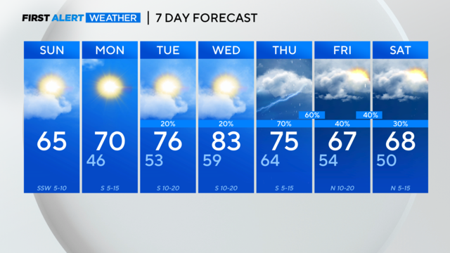
Spring Break weather rolls into DFW with highs in the mid-60s. Showers later this week.
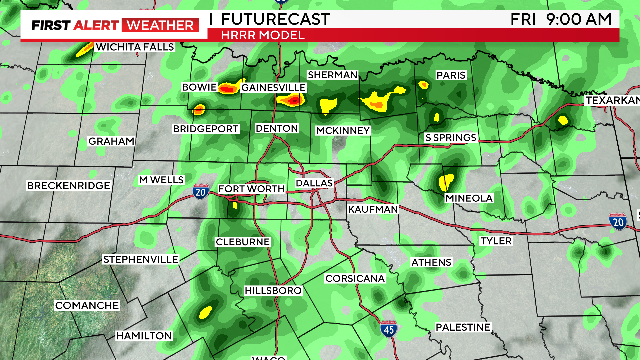
The main threat is large hail, but some storms may produce gusty winds up to 60 mph.
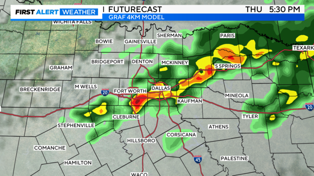
The best chance for strong to severe storms to develop will be by Thursday afternoon and evening.
Parts of North Texas are under level 1 (marginal) and level 2 (slight) risks for severe storms on Thursday.
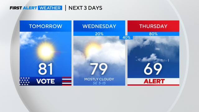
North Texas can expect mainly dry conditions tonight with a low chance for an isolated storm. Clouds return Wednesday with strong storms possible on Thursday.

Most of us will see rain throughout the afternoon, with high temperatures in the lower 50s.
Much cooler weather is moving in overnight.

As we move through this Monday, breezy southwest winds will push our high temperatures into the low 90s, likely shattering our record high of 90 degrees set back in 1917.
Winds could gust to 20-25 mph at times.
As we move through this Monday, high temperatures will be in the mid 60s under sunny skies.

We started VERY warm this morning. By lunch hour, we were in the 70s. We won't see temperatures that warm again until next week.
High temperatures will be in the low to mid 60s under sunny skies.