
Weather Alert continues due to threat of severe storms in North Texas
Severe storms are possible Wednesday and Thursday.
Watch CBS News
Severe storms are possible Wednesday and Thursday.

Highs will warm into the upper 80s by the afternoon. Tonight, temperatures will be in the low 70s under mostly clear skies.

We're watching the CAP in our atmosphere. If it breaks this afternoon, we could see a few storms that could be strong to marginally severe, especially north of I-20.

Severe storm chances increase this evening.

As we move through this Thursday morning, showers and storms will continue pushing east through North Texas.

Flooding, large hail and damaging winds are all possible.

Get ready for even more showers and storms this week into your weekend.

Highs will be in the mid-80s. Tonight, we'll see mostly clear skies with low temperatures in the lower 60s.

We are watching everything east of the I-35 corridor for severe weather development Sunday afternoon.
On Saturday, a few isolated showers and storms are possible by afternoon. However, the greatest threat for strong storms will arrive late Saturday night into Sunday morning.

It's a milder start to the day with temperatures in the upper 50s.
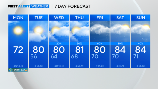
A gorgeous North Texas Earth Day! Warming temperatures and late-week rain chances.
Severe storms head for parts of North Texas Thursday before a big cool down this weekend.
We're not expecting a washout but an isolated strong storm is possible with gusty winds and lightning. Otherwise, expect a mix of clouds and sunshine.
CBS News Texas meteorologists have a weather alert posted for tonight into early Tuesday. Storms will likely impact our area from about 7 p.m. to 2 a.m.
A Weather Alert is out for Monday evening and overnight.
We are starting off your Saturday with some cloud cover but the clouds will continue to break up, giving way to mostly sunny skies.
As we move through this Friday, after a cool start, our high temperatures will climb to near 80 degrees this afternoon.

Tonight, we'll see mostly clear skies with low temperatures in the low 50s.

We're tracking another round of rain and strong storms in North Texas.
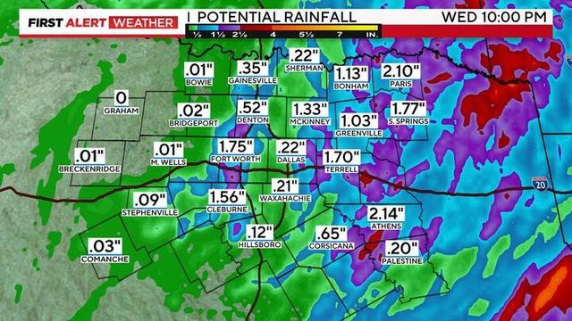
The alert continues Tuesday night for the potential of some isolated strong to severe storms.

As we continue moving through the morning drive, we'll see a good deal of the rain and storms tapering off before another round moves in late morning into the afternoon and evening.
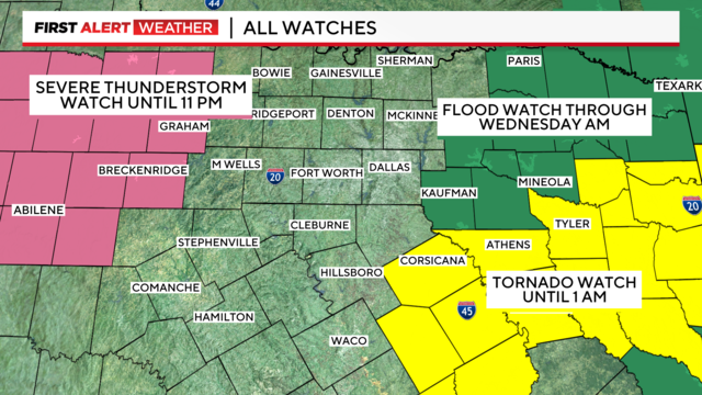
Flooding threat could continue into Wednesday.
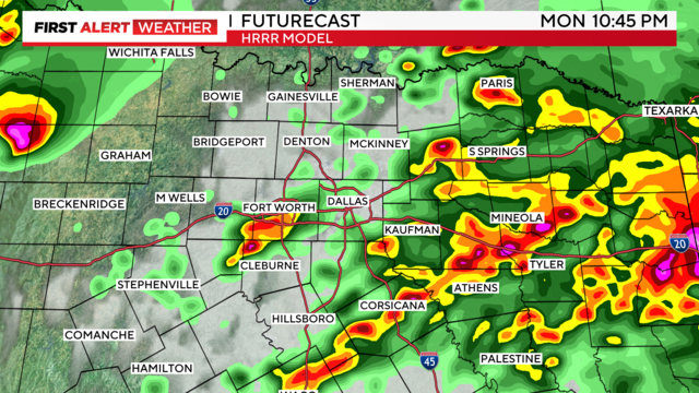
The main threat Monday evening will be large hail, but tornadoes and damaging winds are also possible.
High temperatures will climb into the low 70s this afternoon under sunny skies.