
Moisture from Gulf of Mexico sticks around, North Texas remains muggy and hot
Tuesday will be another hot day with temperatures topping out in the low 90s but feeling more like 100 degrees thanks to the continued tropical moisture in North Texas.
Watch CBS News
Tuesday will be another hot day with temperatures topping out in the low 90s but feeling more like 100 degrees thanks to the continued tropical moisture in North Texas.

Tropical moisture will make it feel even warmer on Monday despite the high temperature only warming to the low 90s.

The sunshine and dry conditions continue right through Father's Day, due to high pressure in the area.

We are waking up to a few showers across Dallas-Fort Worth but they will break up by mid-morning with partly cloudy skies this afternoon.

North Texans will experience one more day of thunderstorms before an entirely new weather pattern starts on Wednesday.

The morning will be mostly dry before a 40% chance of storms develops in the afternoon.

The heavy rain and storms moved out of the area and we are not looking at another round of storms Wednesday night.
Large hail, damaging winds and flooding are the main threats but an isolated tornado can't be ruled out.

Severe weather is not expected, but lightning and gusty winds are possible.
The dry line storms moving east will encounter a relatively stable airmass and are forecast to weaken as they move east.

Dig out the rain gear and keep it handy all week.
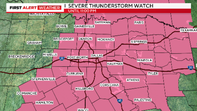
The severe threat has shifted to the southeast.

Large hail and damaging winds are the main threats with these storms. Later in the afternoon the dry line should fire up a line of strong storms.

The severe weather threat continues Wednesday night with the potential for isolated strong to severe storms.

First Alert meteorologists have issued weather alerts for Wednesday and Thursday due to threat of severe storms.

Large hail, damaging winds with localized flooding are the main threats but there is a low tornado threat.
As the breeze continues today, moisture will only continue to increase.
The timeframe for Wednesday looks to be more late afternoon and into the evening, while Thursday could be more scattered throughout the day.
Saturday was a very June-like summer day, dry and highs in the low 90s.

Highs for this weekend look more like the temperatures you would see in mid-June than mid-May. Rain returns to the forecast by mid-week next week.

A drier and warmer weekend is ahead as the rain coverage and intensity has mostly come to an end Thursday.

Grab the rain gear as you head out the door, CBS News Texas meteorologists have issued a weather alert for today.
Put the sunscreen on today because the UV index will climb to the 'very high' category.

A weather alert has been issued for Thursday this week. Flooding remains a huge concern along with the possibility of some stronger storms.
A cold front moves through later today which will sweep out the moisture, leading to a sunny Tuesday and Wednesday.