South Florida warms up before cold front arrives mid-week
The coldest air of the season, so far, arrives on Wednesday morning with lows falling to mostly the upper 40s.
Watch CBS News
The coldest air of the season, so far, arrives on Wednesday morning with lows falling to mostly the upper 40s.

A warming trend will continue into Monday, with highs reaching near 80 degrees. But that won't last for long.

Look for temperatures in the 50s on Saturday and Sunday mornings.

A beautiful, dry day is ahead with highs in the upper 70s.

Another cold front is on the way and Wednesday night's lows will fall to the low 60s.

Tuesday night the weather should be dry and mild for New Year's Eve festivities.

Expect on-and-off showers with a mostly cloudy to overcast sky all weekend.

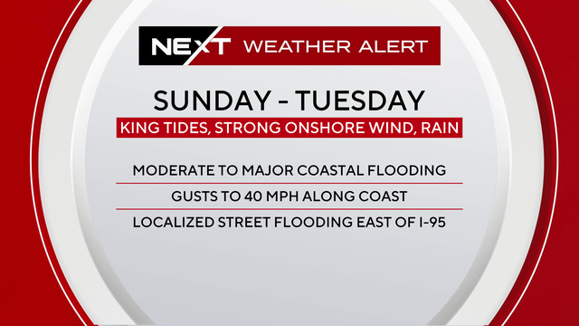
South Florida is under a weather alert, with heavy rainfall allowing for the potential of flooding in some areas of Miami-Dade County. Winds are gusty with temperatures in the 70s.

A Next Weather Alert in effect for Sunday due to the high coverage of rain and potential for some localized flooding, particularly in southern/central Miami-Dade County.

Researchers say human-caused climate change dealt people an average of nearly six weeks of extra extreme heat in 2024, while also fueling more destructive storms.

On Friday, the chance of rain begins to rise with the potential for passing showers.

Today will feature more clouds than Tuesday as a front remains stalled across the area.

Today will be much like yesterday, with a mix of clouds and sun and highs in the upper 70s. Most areas will remain dry, with just a chance for a stray shower.

It will be a mild few days in South Florida but there is a chance of rain tomorrow and the rest of the week.

After a chilly weekend, warm weather lovers will get to look forward to a much warmer forecast as we approach the holidays.

We'll enjoy another beautiful day with plenty of sunshine, and just a few clouds set to drift in during the afternoon.

A warming trend will kick off Monday in South Florida with showers expected mid-week.

The brief cool snap will give way to warmer temperatures this week.

An ice storm created treacherous driving conditions in Iowa and eastern Nebraska over the weekend. Meanwhile, San Francisco was under a tornado warning.

Monday will bring more of the same, with on-and-off breezy showers, and winds gusting up to 30 mph with highs around 80 degrees.

Monday will bring more of the same, with on-and-off breezy showers, and winds gusting up to 30 mph with highs around 80 degrees.

Sunday will be a "rinse-and-repeat" of Saturday

But temperatures will drop again midweek bringing a line of showers Wednesday afternoon.

A stunning Sunday in store for South Florida.

Morning low temperatures should heat up through midweek when another cold front moves through.