Chicago First Alert Weather: Cooler than average temps
The cold front is to our south, allowing a cooler, northeast wind flow to continue.
Watch CBS News
The cold front is to our south, allowing a cooler, northeast wind flow to continue.

Saturday will feature a chance for rain in the morning, the mostly cloudy skies, breezy south winds and warmer temperatures in the afternoon. Highs will be in the mid to upper 80s.

Cool and comfortable to start the day.

According to CBS 2 Chief Meteorologist Albert Ramon, high pressure over the area will make for a sunny and dry Wednesday.

Clearing and cooler on Tuesday with highs in the 70s and lowering humidity.

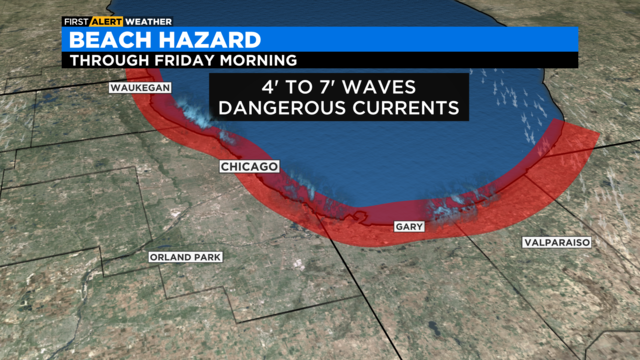
A Beach Hazards Statement also has been posted for Monday afternoon until Tuesday afternoon.

Although widespread severe storms are not expected, storms producing gusty winds and torrential downpours will be possible.

Steamy weather holds through Saturday night with lows in the 70s.

Dewpoint temperatures in the lower 70s will make it feel near 100 degrees.

Partly cloudy skies tonight with lows in the low 70s. Some patchy areas of fog will be possible, especially for areas south of I-80.

Temps increase over the weekend. A chance of storms by the end.

According to CBS 2 Chief Meteorologist Albert Ramon, it'll be partly cloudy overnight with lows in the upper 60s. Some patchy fog is possible for areas near the lake.

Temperatures will begin gradually heating back up on Friday.

Isolated showers and storms will remain possible through the evening.

The storm warnings come amid the hottest day of the week.

The extra humidity will make it feel like it's in the low 100s with the heat index.

Rainfall amounts over the next five days could range from a half inch to the north, to as much as 2 inches in parts of Northwest Indiana.

Sunday night brings the chance of storms by daybreak and a low temperature of 68 degrees.

Perfect summer weather for Chicago.

Saturday night will bring mostly clear skies and a low temperature of 64 degrees.

Mostly sunny skies this weekend with temperatures right around normal
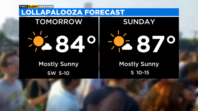
High pressure settles overhead Saturday and Sunday allowing for plenty of sunshine.

Drier air has moved in behind the cold front Thursday.

According to CBS 2 meteorologist Mary Kay Kleist, it will taper off with sunset. Skies may actually clear a bit overnight until the second front moves into our area.

According to CBS 2 meteorologist Mary Kay Kleist, skies become partly cloudy between two fronts.