Warmup begins for Chicago area; wintry system moving in
Temperatures will finally get above freezing late Monday or into Tuesday.
Watch CBS News
Temperatures will finally get above freezing late Monday or into Tuesday.

A wintry system brings a chance of a wintry mix Monday night into Tuesday.

Most of the lake effect snow in Northwest Indiana has shut down, but the whole Chicago area is in for another cold night.

CBS 2 Meteorologist Robb Ellis has the 5 p.m. forecast for Saturday, Jan. 20, 2024.

Northwest Indiana continues to deal with lake-effect snow through late morning.
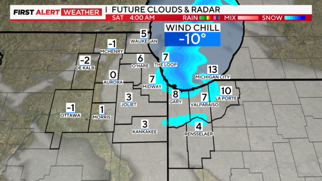
An additional 2 to 6 inches of snow will be possible through Saturday midday in Northwest Indiana.
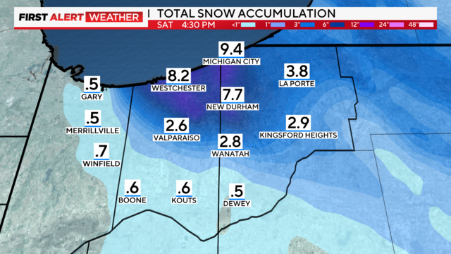
Near-blizzard conditions are possible along the Indiana Lakeshore, with gusts up to 40 mph.

CBS 2 Chief Meteorologist Albert Ramon has the 5 p.m. forecast for Jan. 19, 2023.
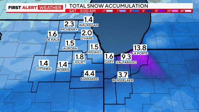
Total accumulations of 1-3 inches are anticipated through the morning commute on Thursday, which could lead to slick travel conditions.

A Wind Chill Advisory is in place until Wednesday at 9 a.m. for the entire Chicago area.

West winds gusting 30-40 mph this morning are creating near-blizzard conditions with visibility near zero and blowing and drifting snow.

While snow is obviously an important factor, it's also about wind and visibility.
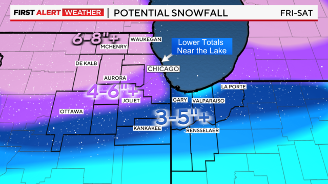
Total accumulations could reach 10 inches or greater for parts of the Chicago area on Friday, with wind gusts as high as 45 to 50 mph.

The storm is already having effects has Amtrak cancels 18 trains out of Chicago.

The first wintry system of the season arrives Monday night and brings rain and snow on Tuesday.

A wintry system with significant snowfall will arrive in the area Monday evening.

The city says salt spreaders will focus on addressing ice along Chicago's arterial routes and on DuSable Lake Shore Drive to ensure they are safe and passable for emergency vehicles, public transportation, and motorists.

Expect Winter Storm Watches to be posted by Sunday afternoon.

Accumulations of 1 to 3 inches are possible early Saturday.

Snow showers will increase late in the evening and be with us through Saturday morning. CBS 2 is watching the potential for a larger snowfall on Monday and Tuesday.

Monitoring a strong storm system next week arriving late Monday, bringing accumulating snow and colder temperatures.

According to CBS 2 Chief Meteorologist Albert Ramon, more sunshine is set for Thursday with highs in the mid-30s. Partly cloudy skies for Friday with highs in the mid to upper 30s.

Drizzle is possible late but as temperatures fall below freezing, freezing drizzle is possible by morning.

CBS 2 Chief Meteorologist Albert Ramon has the 5 p.m. forecast for Jan. 1, 2024.

There's a chance for lake effect snow in Northwest Indiana late Wednesday as a front moves through the area.