Winter storm for Chicago: Heavy blowing snow on Friday; how much could we get?


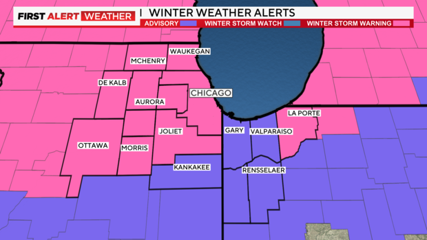
CHICAGO (CBS) -- The National Weather Service has issued a winter storm warning for the Chicago area from early Friday through Saturday morning, with heavy blowing snow expected to make for dangerous travel conditions.
A winter storm warning has been issued for most of the CBS 2 viewing area from 3 a.m. Friday until noon Saturday -- except for LaPorte County, Indiana, for which the timing is 10 a.m. Friday until 7 p.m. Saturday, and Kankakee County in Illinois and Jasper and Newton counties in Indiana, which are under a winter weather advisory,
Conditions will remain mostly cloudy on Thursday. And another winter storm, stronger than anything seen this season so far, is forecast to impact the region Friday, especially Friday night into Saturday morning.
Timing of Chicago's snowstorm
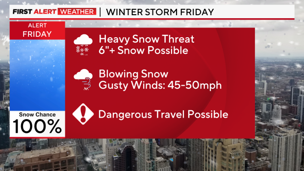
A much larger and more impactful storm system is expected Friday into Saturday. This major winter storm will bring heavy snowfall and strong winds, resulting in hazardous travel and possible blizzard conditions Friday night through Saturday morning.
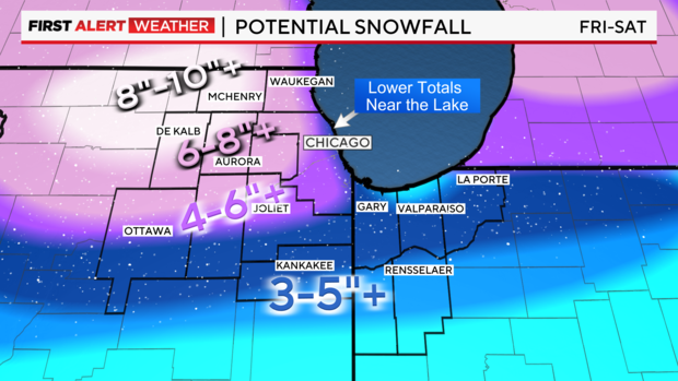
Areas north and west of Chicago could see 8 to 10 inches of snow – and severe impacts. The heavy, wet snow Friday will change to a drier, blowing snow Friday night as temperatures rapidly fall and winds gust over 40 mph.
Strong easterly winds Friday morning will shift to very strong westerly winds Friday night with gusts 45-50 mph causing blowing and drifting snow. Travel will be hazardous to dangerous with low visibility and slick roads.
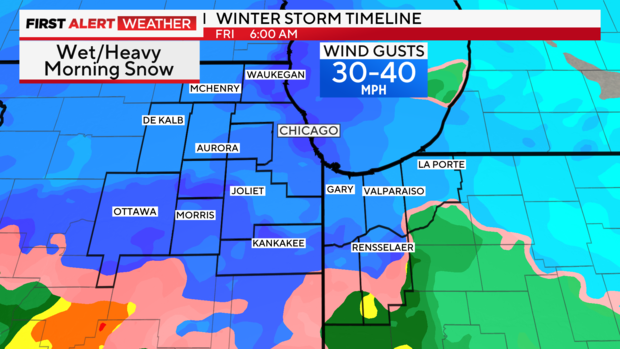
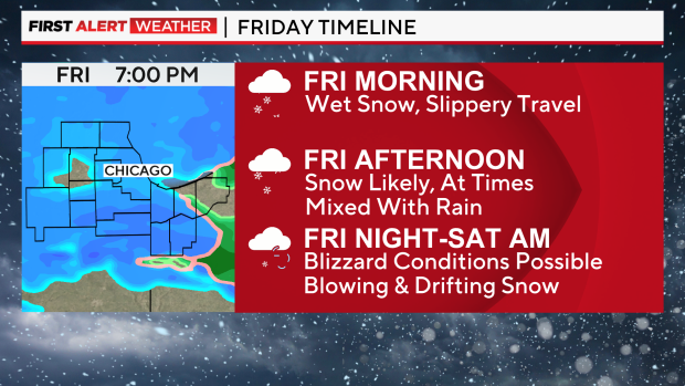
Snow will increase after midnight. Here is the current timing of the storm:
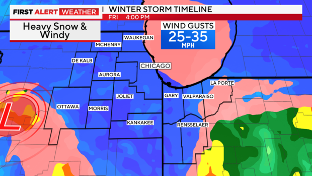
3 a.m.-7 a.m Friday: Chance for heavy wet snow with significant travel issues possible.
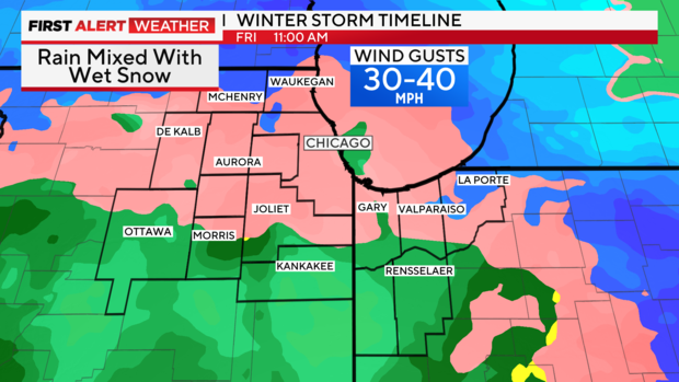
7 a.m-2 p.m. Friday: Wet snow mixed with rain at times. Possibly all rain in parts of the Chicago area by midday.
3 p.m.-9 p.m. Friday: Snow, very heavy at times. Blowing snow chances increase by sunset.
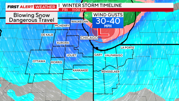
9 p.m. Friday-2 a.m. Saturday: Snow continues, but not as heavy. Gusty winds will create dangerous blowing and drifting, near blizzard conditions for some.
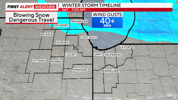
2 a.m.-noon Saturday: Snow ends, but blowing and drifting continue making for dangerous travel. Blizzard-like conditions through sunrise.
The worst impacts look to be along Interstate 290/Interstate 88 and points north, but away from the lake. There is also an increasing chance of 8 or more inches in parts of the western/northwestern suburbs. The lake will cut down on totals along the immediate lake, including the Loop.
Potential for blizzard conditions
The heavy blowing snow could significantly reduce visibility, making for dangerous driving conditions during both the morning and afternoon commutes on Friday.
The National Weather Service said the strong winds could bring down tree branches and cause blizzard-like conditions Friday evening into early Saturday. Hazardous travel is likely with periods of heavy snow and blowing snow Friday night into Saturday morning.
Dangerous conditions are also likely through Saturday, with blowing snow and wind chills near zero. There remains some uncertainty around the exact storm track and snow totals, so stay tuned for updates.
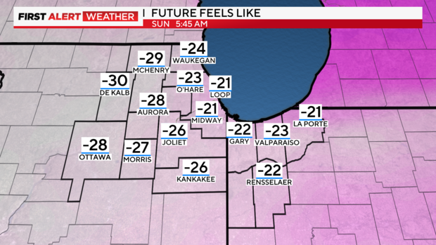
Much colder air will arrive in the wake of this system, with the coldest air of the season expected this weekend into early next week. Dangerously low wind chills are likely Sunday through Wednesday mornings.
Wind chills on Sunday evening could drop to 20 degrees below zero, with the actual temperature falling below zero for the first time this season and daytime highs not climbing out of the single digits Sunday through Tuesday before reaching the teens on Wednesday.
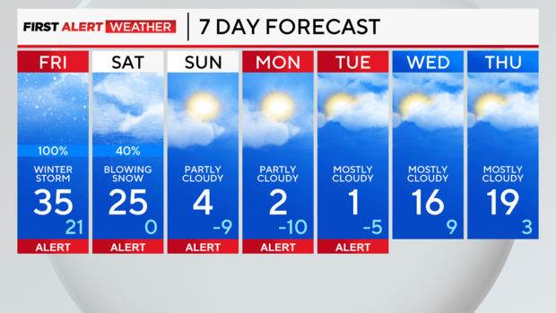
Forecast
Tonight: Cloudy with snow developing. 1-2 inches of accumulation north of I-80. Lows in the upper 20s, slowly rising overnight.
Thursday: Cloudy with morning snow showers ending. Breezy and turning colder with highs in the low 30s. Watch for icy spots early.
Friday: Cloudy with rain and snow developing in the morning, then snow likely in the afternoon. Windy. Highs in the low 30s.