
Watch CBS News

The closer to the coast you are, the drier you will be thanks to high pressure off shore. Despite a little light rain early, a good portion of the day should remain dry with temps in the mid 70's. Hard to completely rule out showers completely today for eastern sections...as a few showers could break off the main batch out west from time to time. Either way, a cloudy, humid and tolerable Sunday if you have to be outdoors in eastern MA.
Clouds will continue to gradually increase and thicken through the weekend. While the coast should remain dry tomorrow, the risk inland for showers increases, especially once you get west of Worcester. The clouds and cool SE winds will keep temps in the 70's near 80. The warm spot will be NH and ME in the Lwr 80's. Only in the upper 60's and Lwr 70's where it will be raining out west.
On this edition of "Centro," WBZ's Yadires Nova-Salcedotalks with El Planeta's Advertising Director, Raul Medina. Tune in!
Tracking a complex of rain and thunderstorms moving out of the Catskills. This will continue to spread clouds our way the rest of the evening. Most of the rain has waited for the evening hours...where is will be out west from 6 PM -9PM, then begin to shift east, Heaviest rain will be found after midnight. The column is loaded with moisture, so expect a few heavy downpours and maybe even some embedded thunder.
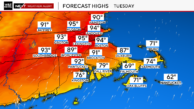
A warm and muggy night, but a cold front will push off the coast and drier air will move in overnight with clearing skies and lows in the 60's. Tuesday will be a warm, but less humid day. There will be plenty of sun in the morning, but cooler air aloft supplied by an upper level low over us will keep the air unstable. Expecting building PM clouds with the potential for a spot shower or thunderstorm. Breezy WNW will warm the coastal plain with many areas climbing into the mid-upper 80's
Monday will be a hot and more humid day with hazy sunshine and scattered afternoon storms. Most areas will reach near 90 degrees.
Isolated to Scattered Strong to Severe Thunderstorms are likely Monday Afternoon and Evening across the entire NWS Taunton County Warning Area. Damaging Winds, Large Hail, and urban/poor drainage flooding are the primary threats..

This gridlocked mess is partly because all the possible answers contain political kryptonite, including one with serious implications for New England.

With high pressure overhead, drier air, light winds and clear skies...we are in store for a gorgeous summer night with temps dropping down to 60-65 in Eastern MA...with lows in the 50's in western valleys. More sunshine for Wednesday with temps once again climbing towards 90 with moderate humidity.
Best chance of any thunderstorm activity now will be from 6pm-12 am, and any storms that form could contain very heavy downpours, frequent lightning, damaging winds and some small hail. The atmosphere is very ripe in extreme Southern New England (parts of CT, RI and SE Mass and farther south towards the Mid Atlantic). So those would be the most likely areas for any severe weather later this evening.
It's getting mighty hot out there today! Temps on their way to 90-95 degrees with breezy WSW winds. The only sea breeze you will find today will be along the south coast keeping those beaches in the 80's. A muggy summery evening with skies becoming partly cloudy after midnight with some patchy fog at the south coast with the increasing dewpoints.
The cold front which helped to trigger strong to severe storms late yesterday across the Pioneer Valley has weakened and stalled over southeast MA. This cold front will likely become the trigger for a few scattered showers or thunderstorms to form later this afternoon across Bristol, Plymouth and Barnstable counties. These areas, including along the south coast have dewpoints in the upper 60's to near 70 which will help to fuel the scattered afternoon convection.
Morning Low clouds are thinning and breaking for some increasing midday and afternoon sunshine. Low clouds linger a bit longer at the coast...especially on the Cape. West winds along with increasing hazy sun will give a warm muggy to feel to the air this afternoon with highs climbing into the 70's and Lwr 80's. Light winds will mean a seabreeze at the coast
A sunny and pleasant day today as dewpoints continue to drop making it feel very comfortable outside. Upper low over the maritimes wrapping in dry Canadian with building high pressure at the surface providing mainly dry pleasant conditions for the next 48 hours
Highs will climb into the Lwr 80's with a warm humid feel. We are tracking a shortwave which will be pushing south into New England. A cold front will push through the region during the afternoon and likely fire up some scattered convection in the form of a few showers or thunderstorms. The best chance of these showers and storms will be around 2 PM-6 PM before exiting the coast tonight.

What if Dad can no longer maintain his home or comfortably live there because of the stairs or outdated plumbing?
Scattered showers have been crossing through the region this morning. These will be hit or miss showers which will pretty much persist for much of the day it appears in varying intensity. Highs in the Lwr-mid 60's
We are socked in the clouds this Sunday with cool onshore NE winds keeping temps running below normal. Very chilly at the coast with areas of drizzle and mist this morning. Temps at the beaches will likely remain in the 40's and lwr 50's. Farther inland a better chance of some warming into the 50's and Lwr 60's. with mid 60's in the CT river valley. Mostly cloudy conditions will prevail, but there is the potential for a few breaks of sun in any thinner overcast this afternoon inland.
Our pesky low wich brought a week in the clouds with periodic rain is pulling far enough away today that temperatures are finally able to warm up. Morning clouds and fog are breaking for partial sunshine and an overall pleasant Saturday. Temps are warming inland into the Lwr to Mid 70's, while eastern areas, especially at the coast will hold in the 60's.
Heavy Rain pushing through the CT and Pioneer Valleys this morning is shifting east for the midday and afternoon hours. Strong Southerly winds aloft are advecting warm moist air into the northeast. A cold front from Canada is pushing south into New England today...bringing colder air behind it. This will create perfect overrunning and lift to Midday-afternoon showers and downpours to develop. SE winds will try to push temps into the lwr 60's south before the rain moves in...once the rain falls...it is 50's for all!
Plenty of low clouds and fog at the coast this morning. Clouds are already breaking inland giving way to some partial sun thanks to high pressure off the coast. Winds are light out of the SSE with plenty of cloud cover around today. Still, any breaks will be appreciated and help turn this Saturday into the pick of the weekend with dry and mild conditions with highs climbing into the upper 60s and lwr 70s away from the coast. Breaks of sun are likely through the early afternoon with clouds spreading from west to east from New York state to end the day on the cloudy side.
Morning sunshine with SW winds will give temps a boost well into the 60's and lwr 70's for highs today. Clouds will begin to build with the heating of the day. Expect widespread scattered showers and thunderstorms to develop this afternoon with lightning, small hail, gusty winds and downpours.
A gorgeous day! NE winds will keep it cooler at the coastline in the Lwr-mid 50's. Away from the onshore winds, temps will continue to warm through the day into the Lwr-mid 60's, near 70 west.
Building high pressure this weekend will wrap in drier air along with cooler NNE winds and return temperatures to more seasonal levels for this time of year. A weak front is pushing off the coast this morning. This came with a few light sprinkles or showers overnight and a deck of mid level clouds which is eroding away this morning.

Willson Contreras hit his team-leading 10th homer and Sonny Gray outdueled Seth Lugo as the Boston Red Sox beat the Kansas City Royals 3-1 on Monday night.

WBZ-TV's Lisa Hughes got a big surprise when a duckling wandered into her yard and sought her out for protection.

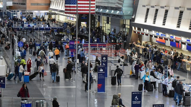
A new option is coming for travelers looking to avoid long security lines at Logan International Airport and potentially save money on rides and parking.

Karen Read's Lexus SUV is now for sale at a Massachusetts car dealership, listed for just under $100,000.

Thousands of Greater Boston students will soon experience live Shakespeare, and for some, it will be their very first time.

A viral video taken at a Southbridge, Massachusetts McDonald's is leading to criminal charges.
After a glorious weekend in Boston, the weather forecast calls for possible record-setting heat to hit the city

A group of Good Samaritans, including an off-duty firefighter, rushed into action when a car rolled over on Interstate 495 in Massachusetts Sunday afternoon.

The sexual assault trial of Alvin Campbell, the brother of Massachusetts Attorney General Andrea Campbell, began Monday.
A new option is coming for travelers looking to avoid long security lines at Logan International Airport and potentially save money on rides and parking.

Many people fear that a family history of dementia dooms them to inevitably suffer the condition themselves. But a new tool, the Brain Care Score, shows how lifestyle changes can be beneficial, cutting the risk of dementia.
There was a possible measles exposure at Logan Airport in Boston last week, Massachusetts health officials say.

A new study finds that a simple blood test could predict Alzheimer's disease long before symptoms appear.

The Lone Star tick, which can cause alpha-gal syndrome, is spreading north throughout Massachusetts.
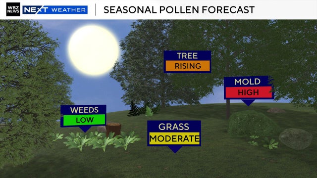
Boston's cold and snowy winter might have an effect on this year's pollen allergy season.

A driver from Southboro, Massachusetts struggled for months to unravel a frustrating mix up with his E-ZPass account.

The gunman who allegedly opened fire on passing cars on Memorial Drive in Cambridge, Massachusetts is 46-year-old Tyler Brown from Boston.
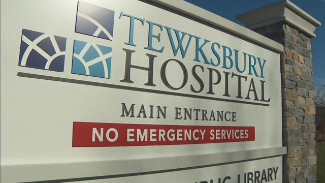
There have been four violent attacks in three weeks at Tewksbury Hospital and a state representative is taking the fight to Beacon Hill to give security the non-lethal equipment back.

A family is demanding answers from the Gloucester, Massachusetts school district, after learning their five-year-old son was left alone in a quiet room for nearly half an hour.
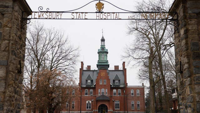
A nurse says the decision is leaving the staff and patients at Tewksbury Hospital vulnerable to serious injury.

Both the Trump and Healey administrations are using government websites to blame each other for the shutdown.

Which party stands to take more of the blame from voters for the government shutdown? Here's what a new poll says.

A UNH Survey Center/Granite State poll shows John Sununu crushing Scott Brown by 23 points among likely primary voters in New Hampshire.

Seth Moulton said he's running against Sen. Ed Markey because "our party leaders are clinging to that old playbook."

Maine Governor Janet Mills' run for Senate comes with an unusual promise - she will only serve one six-year term.

Dover Saddlery is closing its Wellesley, Massachusetts store and preparing for more than 100 layoffs.

The "dirty soda" trend is coming to drive-thrus all over Massachusetts as Dunkin' is now serving up its own version of the viral drink.
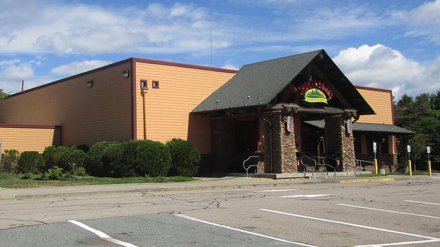
Smokey Bones is closing all of its restaurants, including Massachusetts locations in Tyngsboro and Taunton.
Boston ranks right up there with Hawaii as one of the most expensive vacation spots in the country, according to a new report.

The Market Basket Board of Directors was justified in firing longtime CEO Arthur T. Demoulas, a judge ruled Monday.
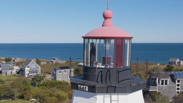
Known formally as Gurnet Light, a historic lighthouse has guided mariners at the entrance to Plymouth Harbor for generations.
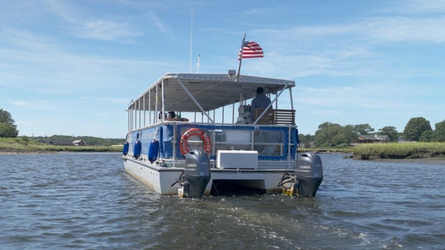
From private cruises to quintessential clambakes, Essex River Cruises offers a front-row seat to the beauty of the Great Marsh.

Argia Mystic Cruises in Mystic, Connecticut is one of the last commercial sailing ships in the region, offering a rare chance to explore the area by sea.

A 2026 James Beard Award finalist for Best Chef, and 3-time Chopped champion, Evan Hennessey uses locally farmed and foraged foots to create artistically inspired dishes.

In Groton, Massachusetts, there is a recently opened state-of-the-art venue that is becoming one of the region's premier nonprofit music destinations.
Willson Contreras hit his team-leading 10th homer and Sonny Gray outdueled Seth Lugo as the Boston Red Sox beat the Kansas City Royals 3-1 on Monday night.

The first-place Braves took two of three from Boston for their 13th win in 15 series this season.

The major league-best Atlanta Braves defeated the Boston Red Sox 3-2 on Friday night.

Kyle Schwarber hit his major league-leading 18th home run and the Phillies defeated the Red Sox 3-1 on Thursday night.

After days of leaks and rumors, the NFL finally released the full schedule for the New England Patriots.

A Boston man says he's lucky to be alive after jumping into the Charles River to save his dog.

Little Joe the gorilla is leaving Boston after decades at the Franklin Park Zoo.

There's been another sighting of an unusual killer whale named Old Thom in the waters off Massachusetts.

A soccer coach in Ludlow, Massachusetts plans to pay it forward after winning big on a lottery scratch ticket.

The Rumney Rocks Climbing Area is partially closed as nesting peregrine falcons could attack rock climbers.