Heat advisory issued for Tri-State Area through Wednesday
Extreme heat and humidity return to NYC to start the week, and we could see our second heat wave of the season.
Watch CBS News
Extreme heat and humidity return to NYC to start the week, and we could see our second heat wave of the season.

It was an extremely active day for weather across the Tri-State Area on Friday, with record-breaking heat and severe thunderstorms.
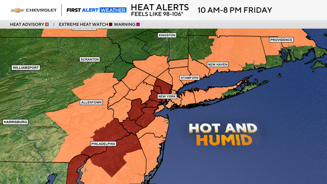
The heat and humidity build Thursday into Friday, and some areas could flirt with heat warning criteria by Friday afternoon.
The humid weather returns to NYC today, along with the risk of some severe storms.

NYC remains under a heat advisory today, as high temperatures hit the 90s and feel more like triple digits.

There's a flood watch for northwestern parts of New Jersey, where communities are still cleaning up from Monday's storm.
Flash flood warnings and watches popped up Monday across NYC and New Jersey, as powerful storms hit the area.

Insurance experts warn property insurance premiums will climb even higher than they already are.
In the evening, we'll see another round of showers and thunderstorms develop, particularly off to our south.

Severe weather caused damage across the region Tuesday, even triggering a tornado warning in parts of New Jersey.
Heavy downpours may suddenly occur and lead to flash flooding Tuesday in the Tri-State Area.
The 4 of July forecast in NYC is looking ideal for holiday festivities and the Macy's 4th of July Fireworks Show.
Thunderstorms produced extensive amounts of damage in numerous locations, but specifically to the area around South Plainfield, New Jersey.
New York City and the surrounding Tri-State Area could see some severe thunderstorms later today.
These storms could bring damaging winds, torrential downpours and hail to the Tri-State Area on Saturday.