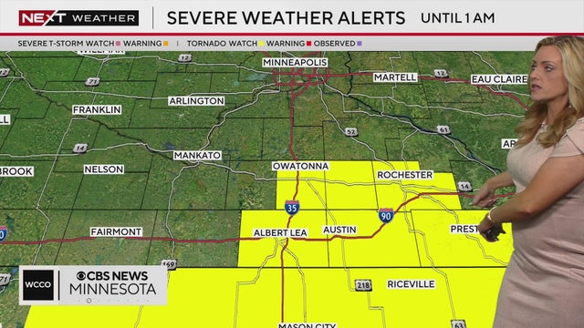
NEXT Weather Alert: Parts of southern Minnesota under tornado watch
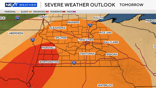
Things turn active on Sunday with a stronger storm system bringing much-needed soaking rains.
Watch CBS News

Things turn active on Sunday with a stronger storm system bringing much-needed soaking rains.
Saturday looks perfect with ample sunshine, highs in the low 80s and less wind than previous days. Things turn active on Sunday.

Friday will be hot, dry and breezy in Minnesota with critical fire weather concerns continuing. Wind gusts between 25 to 30 mph will keep fire danger elevated, especially in western and central parts of the state.

Expect breezy winds, highs in the 70s and sunshine in the Twin Cities on Tuesday, with fire danger out west.

Highs will reach into the mid-70s Monday in the Twin Cities. It will also be dry and sunny — with a risk of wildfires to the west.

The Twin Cities are under a frost advisory and other parts of Minnesota are under a freeze warning overnight Thursday due to temperatures that could fall enough to harm sensitive plants.

Expect dry and quiet weather this week in the Twin Cities, with more frost and freeze threats ahead.

Wednesday will start out chilly in the Twin Cities before temperatures end up in the mid to upper 50s.
Highs on Tuesday will reach the mid-50s, with decreasing winds but some breezy moments. It will be mainly dry with sunnier skies.

Rain showers move out of Minnesota overnight Tuesday, and the clouds will follow.

Clouds remain throughout Sunday in Minnesota as the wind picks up with gusts up to 20 mph by the afternoon.

Flooding at Gooseberry Falls State Park in Lake County, Minnesota, has made some trails in the area inaccessible.

Wednesday will be hot, windy and very dry in Minnesota, prompting critical fire danger for much of the state.
Tuesday will be warm and dry in the Twin Cities, with lighter winds.
A red flag warning for critical fire weather conditions is in effect until 8 p.m. Monday for northern, western and central Minnesota.