It's a #Top10WxDay Saturday before stormy turn on Sunday


Saturday looks perfect with ample sunshine, highs in the low 80s and less wind than previous days.
There is, however, a red flag warning in place due to extreme fire risk until 9 p.m. for central Minnesota. There's also a frost advisory in place for northern Minnesota
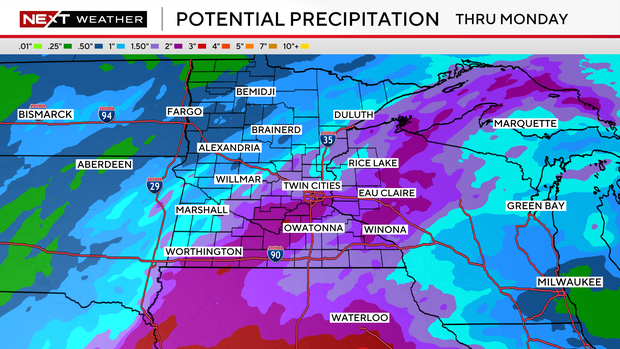
Things turn active on Sunday with a stronger storm system bringing much-needed soaking rains.
Expect scattered showers and storms on Sunday and Monday. Some could be severe, so WCCO is issuing a NEXT Weather Alert for Sunday and a potential alert for Monday.
Sunday morning begins with a chance of rain, but the severe weather threat is for the afternoon and evening hours.
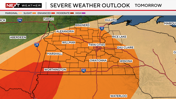
The greatest chance for severe storms is across southwest Minnesota (level 3 of 5) later Sunday with wind, hail and tornadoes possible. Severe weather threat is 2 out of 5 for the metro area and bulk of the state.
Even non-storm winds will be strong with gusts up to 35 mph.
The added clouds knock highs back into the 70s both days.
Monday's round of severe storms is a 2 out of 5 threat for southeastern Minnesota, but things could change depending on how Sunday's storms turn out.
Things look to dry up by Tuesday afternoon after 1-2 inches of rain.
We'll be on the cool side through mid-week with highs in the 60s, but reach the 70s again Thursday and Friday.


