Tracking Chicago rain and storm chances over holiday weekend
CBS 2 Meteorologist David Yeomans has the 5 p.m. forecast for July 3, 2024.
Watch CBS News
CBS 2 Meteorologist David Yeomans has the 5 p.m. forecast for July 3, 2024.

High-pressure overhead will bring sunny skies and dry conditions on Monday.

The National Weather Service has extended the Beach Hazard statement for 4 to 6 feet waves until 7 a.m. Monday.

Lakeside clouds may be around this morning, especially in northwest Indiana, with clearing throughout the afternoon.

After a steamy day with highs well into the 80s, Sunday will feature many hours in the 60s

Skies gradually clear later in the afternoon.

CBS 2 Meteorologist David Yeomans has the 10 p.m. forecast for June 23, 2024.

Most temperatures will hover in the upper 70s, with a northwesterly wind pulling in a drier air mass.

Flash Flood Warnings continue for much of the area, including Chicago, until 3:15 a.m. Sunday.
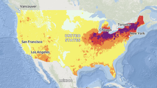
Some areas are expected to see a longevity of dangerous heat that "has not been experienced in decades," forecasters said.

Cooler tonight with upper 60s and low 70s for lows and areas of patchy fog.

Experts said people should avoid outdoor activity if possible, drink plenty of water, and wear sunscreen if they do go outside.

A heat wave is forecast to bring dangerously hot temperatures to the Midwest and Northeast this week.

CBS 2 Chief Meteorologist Albert Ramon had the 5:30 p.m. forecast for June 16, 2024.

Temperatures will soar for several days. On Sunday, the heat index could reach 100 degrees.

Temperatures will climb to the 90s for another muggy day before a cool down on Friday.

More than 20 million people were under weather advisories for extreme heat as forecasts predicted another week of soaring temperatures.

A stray sprinkle is possible overnight.

From 3 p.m. to 6 p.m., funnel clouds or a brief rotation are possible, mainly south of I-80.

CBS 2 Chief Meteorologist Albert Ramon has the 6 p.m. forecast for June 7, 2024.

Tuesday looks to be another unseasonably warm day, with near-record morning temperatures near 70 degrees and afternoon highs in the upper 80s.

A light lake breeze will keep temperatures in the 60s lakeside and 70s inland.

Low-level moisture will create patchy fog overnight.
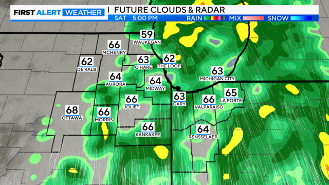
The system's forward speed has slowed slightly, meaning dry weather early Saturday morning through daybreak, with rain increasing mid-morning and peaking in the afternoon.

Additional showers and storms will be possible late Sunday through the evening hours.