Front brings rain, potential for strong storms to North Texas
A First Alert Weather Day is issued for North Texas on Monday due to a frontal passage that will bring the opportunity for stronger thunderstorms.
Watch CBS News
A First Alert Weather Day is issued for North Texas on Monday due to a frontal passage that will bring the opportunity for stronger thunderstorms.

Drizzle and patchy fog will linger in North Texas on Sunday, with temperatures warming into the low 70s by the afternoon.

Drizzle, spotty showers and patchy fog greeted North Texas on Sunday, with a cold front set to move through on Monday.

After a grey and drizzly start, Saturday will warm into the 70s. However, moisture will return overnight.

Mild temperatures and sunshine arrived in North Texas for the weekend, with highs in the low 70s and plenty of blue skies.

A warm weekend with drizzle and spotty rain. Heavy rain Monday, turning cooler late week.

Despite Friday starting with gusty winds and cooler temperatures in the low to mid 50s, a mild weekend awaits North Texas, with highs reaching 71 degrees on Sunday.

A series of fronts brings an active forecast to the area starting Friday and a First Alert Weather Day has been issued for Monday.

Thursday morning across North Texas was cloudy and will remain cloudy through the rest of the day.

Wednesday morning was cold across North Texas with many locations dipping to near freezing.

The wind chill value, known as the feels-like temperature, will be in the 20s.
Another strong cold front is on the way and is forecasted to bring frigid temperatures.

The light winds, chilly mornings, and a moist atmosphere will allow for fog to form on Monday morning.

After a soggy start, North Texans can look forward to warmer temperatures Sunday afternoon before a strong cold front arrives by midweek.

North Texas will experience widespread showers and cool temperatures on Sunday, with reduced visibility due to fog.

North Texas braves wet roadways and scattered showers this weekend, with First Alert Weather Days in effect.

Light to moderate rain is making its way across North Texas this weekend, impacting various holiday activities and potential shopping plans.
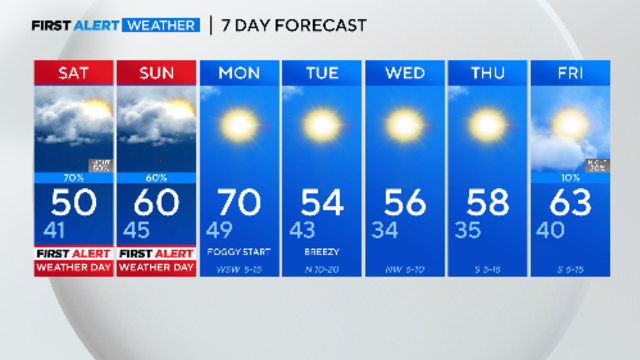
Numerous holiday festivals are taking place across North Texas this weekend, and residents should prepare for light to moderate rain.

As holiday festivities kick off, North Texans should brace for light to moderate rain on Saturday and Sunday, which have been designated as First Alert Weather days.

North Texas started Friday with chilly morning temperatures in the low 30s, followed by rain and cooler temperatures throughout the weekend.

Temperatures are expected to hit freezing on Friday across the metroplex.

North Texas started Thursday experiencing dense fog across the region, with visibility dropping to less than a quarter mile in some areas.

A dense fog advisory is in effect for parts of North Texas until 7 a.m. Thursday. Drivers should use caution, slow down, and use low-beam headlights. Showers are moving east, with drier conditions and patchy fog expected overnight as a cold front passes. Thursday will bring a mix of sun and clouds, with morning temperatures in the upper 30s to lower 40s and afternoon highs in the mid-50s.

A dense fog advisory is in effect for parts of North Texas until 7 a.m. Thursday.
CBS News Texas First Alert meteorologists have issued a First Alert Weather Day for Wednesday due to a rainy morning.