Eclipse watchers pour into Carbondale as Southern Illinois welcomes 200,000
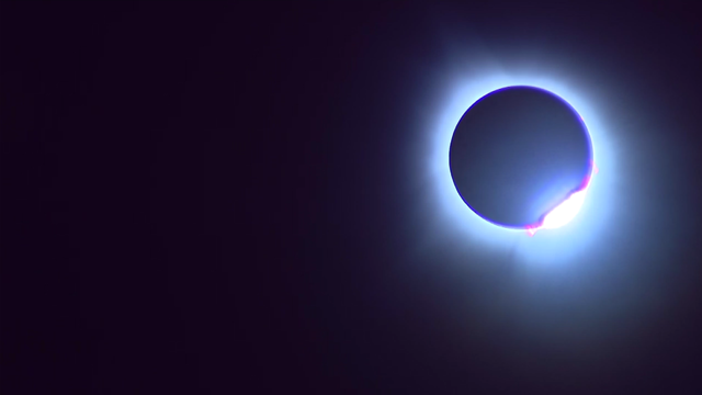
Cheers erupted as the last bit of sunlight wrapped around the moon and turned the skies pitch dark.
Watch CBS News

Cheers erupted as the last bit of sunlight wrapped around the moon and turned the skies pitch dark.
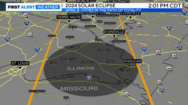
The best places to see the solar eclipse depend on where you are. Chicago is not going to see a total eclipse this time around, but where you are could still offer something impressive to see.
Clear and chilly tonight with lows in the low 30s. Sunny skies for Saturday with highs in the 50s inland, but staying in the 40s lakeside.
Data indicates a partly cloudy sky in the afternoon with highs in the mid-60s for the much anticipated Solar Eclipse.

The funnel cloud was seen in Union Hill, about 15 miles west of Kankakee. It was captured on video amid pounding rain.
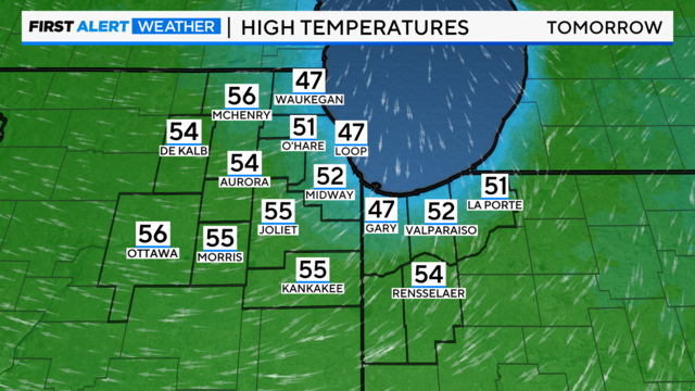
Temperatures will warm into the 50s Friday and Saturday and 60s by Monday.
After some lingering snow and rain showers Thursday, drier weather returns Thursday evening through Saturday as high pressure builds over the region.
Windy conditions Tuesday night and Wednesday, with gusts potentially as high as 50 mph.
There's a chance for strong to severe storms in northwest Indiana in the afternoon, as storms producing hail and damaging winds will be possible.
The main concern will come from storms producing hail and gusty winds.
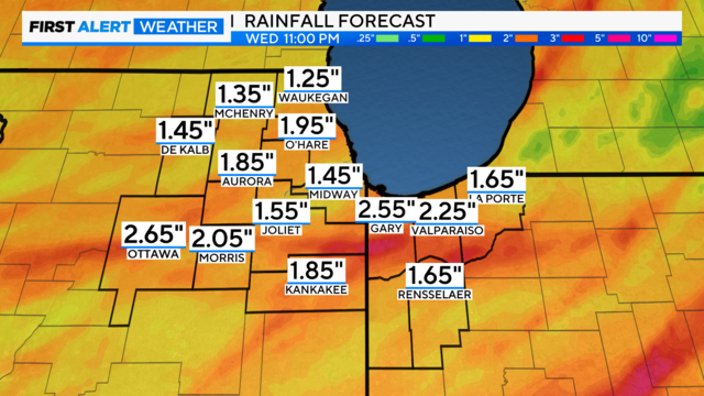
Numerous of showers and storms are expected Sunday evening through Tuesday as a storm system moves through the region.

Some of the thunderstorms on Friday night have the potential to produce heavy rainfall, which could lead to minor flooding.

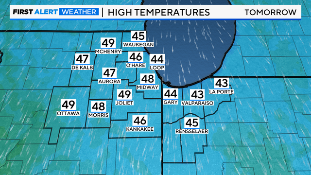
Clouds increase Friday with highs in the low to mid-50s. The coolest readings will be near the lake in the 40s.

Highs on Saturday will be in the upper 50s to near 60 degrees. Rain chances return late Sunday, with highs around 50 for Easter.

We'll see additional showers late Sunday and through the day on Monday for the first day of April.