Hurricane Ian: Here's what to expect if you live in South Florida
Yes, we are out of the cone of concern, but if you live in South Florida, Monday afternoon should have given you a taste of what to expect.
Watch CBS News
Yes, we are out of the cone of concern, but if you live in South Florida, Monday afternoon should have given you a taste of what to expect.
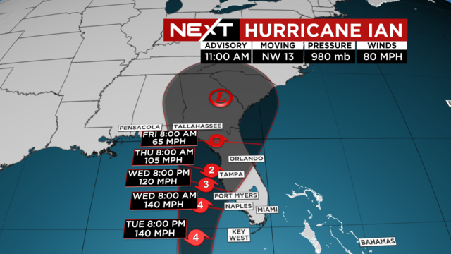
The entire state of Florida is under a Flood Watch as Hurricane Ian, a Category 2 storm, gets closer to the state's Gulf Coast.

Tropical moisture will start to move in on Monday

The latest: Tropical Storm Ian is strengthening and expected to produce significant wind and storm surge impacts in western Cuba.

Tropical Storm Ian is spinning towards the mainland U.S. and as of Saturday afternoon nearly all of Florida was in its cone.

Due to more wet weather around, highs will not be quite as hot

Today is the first official day of Fall but it won't feel like it in South Florida

Thursday is the first official day of Fall

Drier air moves in and lowers our rain chance late week into the weekend.

Scattered to numerous storms are likely Tuesday as we remain unsettled.

The center of Hurricane Fiona is headed directly for the southeastern Dominican Republic, from Cabo Caucedo to Cabo Frances Viejo. Meanwhile, power outages, heavy rainfall and flooding continue to pummel Puerto Rico.

Fiona strengthened into a hurricane Sunday as it bore down on Puerto Rico, where people braced for severe wind and torrential rains.

Saturday the rain chance will still be high with the chance of scattered storms.

The rain chance remains high for Friday

Several slow moving storm cells have triggered flooding warnings for many parts of South Florida.

As a front stalls to our north, deep tropical moisture will enhance our potential for a stormy pattern mid to late week.

Storms may linger through the evening.

This weekend the winds will shift out of the east and bring a change to our weather pattern.

Storms will likely linger through the afternoon and evening

This week's rain chance will be highest on Thursday and Friday

Storm chance will be highest on Thursday and Friday

A warm, steamy start with low 80s. Dry for now but later on some storms will be possible around late morning and midday.

The disturbance in the central Atlantic has a high potential (80% chance) of cyclone development over the next 5 days as it moves West-Northwestward.

A few showers will be possible to start the day. On Wednesday afternoon, highs soar to the low 90s and it will feel like the 100s when you factor in high humidity.

Drier Tuesday compared to Monday, but spotty showers will be possible throughout the morning through midday.