
Watch CBS News
Sunday morning will be filled with sunshine, but another vigorous short wave will be pushing into New England to help enhance lift and instability in the atmosphere. Clouds will be building by midday, with scattered showers and storms starting to pop during the afternoon hours.
A cold front will be pushing through New England Saturday. Saturday morning will see some clouds as well as the potential for a few more scattered showers or a thunderstorm. Not everyone will see them. Westerly winds aloft will direct these scattered showers, clouds through New England during the morning. Drier air should follow in during the afternoon with skies becoming partly sunny and highs in the lwr 80's with falling humidity.

High pressure will remain close enough to us Thursday that we will manage to squeeze out another good day with sunny to Partly sunny skies. Highs will again be in the Lwr 80's inland with 70's at the coast. Clouds will be increasing form east to west during the afternoon. By the evening commute, skies will be cloudy.
High pressure is sitting to the west of New England this evening and wrapping in light NW flow. Temps will be dropping into the 50's overnight in many suburbs. So open the windows, give the AC's and fans a rest and let the cool air settle into your home. Today was so nice we will do it twice! Wednesday looks like another sparkling day with light west winds and highs around 80-85 degrees. Winds will likely turn onshore during the afternoon to keep many beaches in the 70's.
Light onshore winds will keep it cooler at the coast in the 70's, but where there is breaking sunshine and brighter skies, high temps will climb into the Lwr 80's this afternoon. A cold front to our west with more clouds will be pushing into New England late today with scattered showers or a thunderstorms...mainly reserved for western New England. Much of the day will be dry for outdoor events and this afternoon just may be alright...just warm and muggy!
Highs will mostly be in the 60's and Lwr 70's inland at the most today. Not exactly the kind of Friday you want at the end of July. It will likely end up a bit warmer than yesterday. Winds will be shifting to the WNW as the low pulls away and into the Gulf of ME this afternoon, which should help the scattered light showers begin to taper off a bit.
Clouds are socked in with a cool NE winds keeping temps in the 60's. The cold front which pushed through yesterday with all the humidity is now stalled off the coast. Showers are riding up the front and will be slowly lifting into SNE today.
Today a front is moving through which will finally put a beat down to the humidity for a time. Sunshine and west winds have allowed temps to spike into the 80's. Some areas in SE MA may approach 90 degrees before the day is done. It has started out a bit muggy, but dewpoints are already starting to fall in Northern new England with a wind shift to the WNW behind the front.
Behind the warm front, warmer, steamy air with hazy breaks of sun as a dry slot shifts north for the afternoon. Highs climbing into the upper 70's and Lwr 80's south. We will have to watch for scattered showers and storms to start popping again across SNE during the afternoon and possibly form a line of stronger storms which could form and maybe even some severe weather if we get enough sun to break.
A more humid feel to the air, but without the heat in place it is not as uncomfortable. In fact, the light onshore wind will help to keep temps in the 70's and Lwr 80's today. Cooler temps confined to the coast with warmer temps to be found further inland, especially where there is sun.
Sunshine and high to mid level clouds streaming in from west to east. Weak high pressure building in from Canada is helping to steer in a light NNE wind in behind the front which is making for temp in the 70's at the coast and Lwr-mid 80's further inland.
Dewpoints are off the charts today with many areas in SNE in the mid-70's. Mix this in with another day of high heat with highs climbing to near 90-95...well, you know the story. Heat Advisory in effect until 7 PM with a Heat Index, otherwise called Humiture, feeling close to 100-104 this afternoon in the haze.
Temps are quickly warming up this Sunday thanks to a wind shift to the west. Instead of a cool onshore wind, it is a hot land breeze which will help to push many locations this afternoon to near 90. Winds are very light, so with the heating of the day, there is the potential for winds to turn onshore this afternoon for a slight cooling sea breeze for East MA beaches.
Clouds are locked in across SNE for much of the day. We have seen periodic light showers and mist, but most of the time will be dry during the day. We will spend the day on the cooler cloudy side of this front with light onshore winds. This will keep temps in Lwr 70's t the beaches with 70's to near 80 father inland away from any ocean breeze.
Dry air will help for partly sunny skies across SNE today. Highs today will be cool with NE winds keeping temps in the Lwr 70s at the beaches, while inland away from the cool onshore wind, temps will climb into the 70's to near 80 by this afternoon. Clouds will increase again this afternoon.
Partly sunny skies, With light SW winds and very humid conditions will remain in place Monday with highs in the mid-upper 80's. Not as hot but still stuffy! There is a chance with enough sun, that Boston points south could reach 90 again! But watch for afternoon showers and storms!
A heat advisory from 1 PM to 6PM where temps are expected to climb into the mid 90's, with dewpoints in Lwr 70's. This will make the air feel like 100-103 degrees this afternoon. Stifling! Light west winds will warm our eastern facing beaches into the Lwr 90's without much of a seabreeze at all. West winds will make for a warmer day at the south coast too where temps will climb to near 90 near Buzzards Bay and mid-upper 80's on the Cape.
For the Cape, clouds are locked in and here to stay. We will even have to watch for the risk of more showers with embedded thunder approaching during the afternoon. The unsettled weather will keep temps cooler in the Lwr-mid 70's for the Cape, 75-80 for SE MA, including the South Shore, who should remain in the clouds for much of the day as well. Meanwhile, If you head Northwest of Boston, it is a great day as the sun is out and temps will again be warming into the Lwr-mid 80's with partly sunny skies with warm and humid conditions.
Clouds are breaking for partly sunny skies this afternoon with a breeze from the SSW. High temps will climb to 80-85 inland, with 70's right at the coast. Dewpoints are in the 60's to near 70 so there is a real feel of summer in the air
Clouds will break behind the front as drier air will shift in behind with a SW flow aloft. Breaking sun will help temps to warm into the 70's nearing 80. Any long lasting sun could see temps spike into the lwr 80's, especially south. Meanwhile dewpoint temps will rise with the rising temps. A noticeable warm and more humid feel to the air as dewpoints will climb into the 60's nearing 70. Muggy!
Plenty of sunshine in SNE today with highs climbing to 85-90 degrees this afternoon with breezy SW winds. The Cape will stay in the 70's all day with abundant sunshine. A great beach day all around. Dewpoints will begin to climb into the mid 60s during the afternoon making for a more humid and uncomfortable feel to the air.
Highs will be climbing into the Lwr-mid 80's again as the air mass has changed little from yesterday. Dewpoints remain in the 50's to Lwr 60's..which is making for a moderately humid day.

The full strawberry moon will be the biggest and brightest of the year in the weekend evening sky.
Light WSW winds will warm temps to near 80-85 this afternoon with skies becoming partly sunny with a risk of a few isolated pop up shower or T'storm this afternoon.
A 67-year-old man has been charged after allegedly kidnapping and raping a door-to-door saleswoman in Everett, according to the Middlesex District Attorney's office.

It was a picture-perfect day as thousands of Pan-Mass Challenge bikers rode into the Mass. Maritime Academy for day one of the ride.

Another teenager has died following a tragic crash involving a stolen car in Abington, Massachusetts.

Ceddane Rafaela's go-ahead two-run homer highlighted a five-run seventh inning and the Boston Red Sox rallied after blowing an early lead to beat the Los Angeles Dodgers 9-4 on Friday night in the series opener.

The brazen act of violence is part of a troubling series of incidents in and around Boston Common and Downtown Crossing.
Another teenager has died following a tragic crash involving a stolen car in Abington, Massachusetts.
A 67-year-old man has been charged after allegedly kidnapping and raping a door-to-door saleswoman in Everett, according to the Middlesex District Attorney's office.
It was a picture-perfect day as thousands of Pan-Mass Challenge bikers rode into the Mass. Maritime Academy for day one of the ride.
The brazen act of violence is part of a troubling series of incidents in and around Boston Common and Downtown Crossing.

The jury in the Lindsay Clancy murder trial visited her former home and then heard medical testimony in a shortened day Friday.

Several people in New Hampshire have cyclospora infections linked to Taylor Farms lettuce.

Taylor Farms said none of its branded salads or kits contain the iceberg lettuce associated with the outbreak.

A lettuce supplier to fast-food giant Taco Bell has been linked to a nationwide cyclosporiasis outbreak that has sickened thousands of people, the CDC said.

Massachusetts is reporting cases of cyclosporiasis, a disease caused by a stomach parasite that can lead to "explosive" diarrhea.

Many people fear that a family history of dementia dooms them to inevitably suffer the condition themselves. But a new tool, the Brain Care Score, shows how lifestyle changes can be beneficial, cutting the risk of dementia.

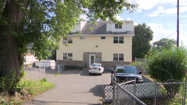
An I-Team investigation into a brazen case of alleged land theft in Concord, Massachusetts has led to criminal charges nearly two years later.

With the Brigham and Women's Hospital nurses strike looming, some parents of newborns in the NICU are sounding the alarm.

A Malden, Massachusetts woman said National Grid took more than $28,000 out of her bank account for a gas bill that she didn't owe.

A Massachusetts family thought their Vrbo stay would be protected after they had to cancel their trip to Hawaii due to severe weather. Now they're out $12,000.

A driver from Southboro, Massachusetts struggled for months to unravel a frustrating mix up with his E-ZPass account.

Barney Frank, a Democrat who represented Massachusetts in Congress for 32 years, has died. He was 86 years old.

Both the Trump and Healey administrations are using government websites to blame each other for the shutdown.

Which party stands to take more of the blame from voters for the government shutdown? Here's what a new poll says.

A UNH Survey Center/Granite State poll shows John Sununu crushing Scott Brown by 23 points among likely primary voters in New Hampshire.

Seth Moulton said he's running against Sen. Ed Markey because "our party leaders are clinging to that old playbook."

Panera Bread is moving its headquarters from St. Louis to Weston, Massachusetts.
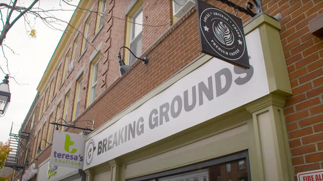
Breaking Grounds Cafe, a Peabody, Massachusetts coffee shop known for employing people with disabilities, is closing.
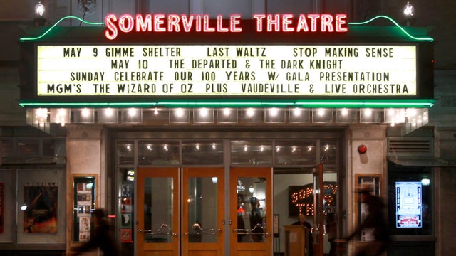
The buildings that house the Somerville Theatre and the Capitol Theatre in Arlington, Massachusetts are for sale.

Golden Temple and Party Favors in Brookline are closing after a combined 100 years in business.

There are no more Hooters restaurants left in Massachusetts.

Beauport, the Sleeper-McCann House has become one of New England's most imaginative seaside estates.
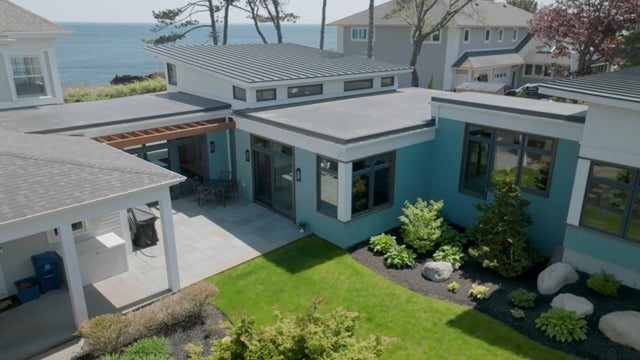
Blending clean modern lines with the warmth of a classic seaside retreat, this stunning North Shore coastal home was designed to feel both elevated and inviting.

Set across thirty acres of rolling lawns, wooded trails, and contemporary outdoor art, deCordova Sculpture Park and Museum invites visitors to experience art in the landscape.

James Beard Award-winning chef and restaurateur Karen Akunowicz has become known for her bold, Italian-inspired cooking and unmistakable culinary voice.

Just a short drive from Newport, the Norman Bird Sanctuary spans 300 acres of fields, forests, and coastal trails with sweeping views and more than six miles of hiking paths.
Ceddane Rafaela's go-ahead two-run homer highlighted a five-run seventh inning and the Boston Red Sox rallied after blowing an early lead to beat the Los Angeles Dodgers 9-4 on Friday night in the series opener.

Romo was arrested in Wisconsin last week, accused of operating a vehicle while intoxicated.

Wilyer Abreu and Wilson Contreras homered on back-to-back pitches in the eighth inning as the Boston Red Sox rallied to beat the Athletics 5-4 on Thursday night.

New England Patriots wide receiver Kayshon Boutte has been shining in training camp despite offseason trade rumors.

Andruw Monasterio hit a two-run home run in the 10th inning and the Boston Red Sox held on to beat the Athletics 4-2 on Wednesday night.
Natick says it is installing a new floating boardwalk across Pickerel Pond.

Rising ocean temperatures are drawing more hammerhead sharks to New England waters, researchers say.

Some of the oldest military veterans in Massachusetts were honored with special flights on Friday in a World War II-era aircraft.

After marrying Taylor Swift and Travis Kelce, Adam Sandler went to Nantucket in search of a basketball court.

An injured hiker had to be carried off a New Hampshire mountain on a stretcher, but that didn't stop her from getting engaged.