
Brief relief for North Texas ahead of possible scattered storms, showers mid-week
Some residents woke to damage from Sunday night's storms that had winds up to 80 mph.
Watch CBS News

Some residents woke to damage from Sunday night's storms that had winds up to 80 mph.

Environmental factors are extremely favorable for storm development.

Overnight storms cleared from Dallas-Fort Worth shortly after midnight, leaving flooding due to heavy rain their wake.

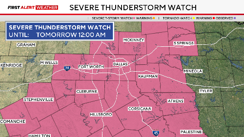
In the late-night hours, damaging winds and flash flooding are the highest risks.

Memorial Day weekend could be rainy.

A string of very nice days is ahead starting Tuesday. More unsettled weather returns by Sunday/Monday.

First Alert Weather Days have been issued for Sunday and Monday due to the severe weather threat.
The storm produced golf ball-sized hail and 60 mph wind gusts

A First Alert Weather Day remains in place Wednesday due to the dangerous heat.

A heat wave is on the way.

As the upper-level low pressure to the east moves further east, a ridge of high pressure will build into the Southern Plains, and that will start to bake North Texas mid-week.

A widespread and impactful round of storms is expected late Monday night through much of Tuesday.

After an active weather day with several inches of rain, large hail, and strong gusty winds, things are calming down, briefly.

By Wednesday, the severe weather threat encompasses the entire North Texas region.

Monday will be cloudy, windy and warm, with potential severe weather threats for much of the week ahead.