
Flood Watch In Effect Through Monday Morning
A flood watch is in effect for the entire area through Monday morning, as we are looking at about 1-1.5" of rain in all of Central and Eastern Mass.
Watch CBS News
A flood watch is in effect for the entire area through Monday morning, as we are looking at about 1-1.5" of rain in all of Central and Eastern Mass.

Clouds will be on the increase tonight. These clouds will trap in todays warmth. This along with south winds should help to keep temps pleasantly mild through the overnight in the 40's. Temps will be climbing right back into the 50's tomorrow as warmer air remains in place along the eastern seaboard ahead our approaching rainfall.

Plenty of clouds are locked in for the weekend...but southerly winds will be blowing in the feel of spring!

The big storms are over, but powder skiing can still be found on the groomed trails of northern areas of New England.
The snow is really winding down in intensity this morning. this trend will continue as dry air from the midlevels moves in. Plenty of low clouds will remain locked in with light NE winds with the potential for scattered light rain/snow showers at the coast with drizzle. Breaks of sun will be possible out west in the afternoon away form the marine air. Temps will recover this afternoon with some of the snow melting with temps back into the 30's to near 40 in SE MA.
Winds have diminished as weak high pressure sits near us today and moving through the mid-Atlantic states. Sunshine this morning with increasing high to mid level clouds this afternoon ahead of our next disturbance. Highs will be cooler than normal in the lwr-mid 30's.
Clouds are on the increase ahead of a cold front which will push through New York then New England by the end of the day. Winds will pick up out of the SW ahead of this front with gusts to 30 mph. After a cool start, highs will climb into the mid-upper 30's with the Cape edging near 40 this afternoon.

WBZ-TV Meteorologist Joe Joyce has the latest ski report.
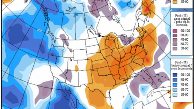
Looking down the road we have been talking about a pattern change. But there still is some cold, a few clippers and a trough in place across the Northeast through next Tuesday which will help to keep New England in the Cool...but how cold will it be?

Many of us maybe looking forward to the warmer temperatures, but there is a concern that too much warmth too fast may cause the return of spring river flooding.
Talk about a Super Sunday! So nice outside. In fact this is the warmest we have been since January 2nd when we reached 51 degrees. Nice to finally thaw a bit. Highs today will climb to 40 to 46 degrees in the sunshine and diminishing wind behind our departing low whose low pressure has dropped down to 981 mb over Nova Scotia.
A solid .50"-1" of rain is likely and this water will easily be absorbed by the snow pack to only become heavier and add more stress to the rooftops. As the storm deepens over us tonight and pulls away, a change over to snow will occur mainly after midnight..with northern New England having the best chance of any substantial snowfall. SNH could see 1-2" with N. MA a coating to an 1" at best as the storm departs.

Powder alert! The one-two punch of snow delivered a foot or more of new powder, just in time for the weekend warriors.

The weight of the snow and rain has caused quite a few problems with buildings around the region.

The situation remains very serious with reports of numerous roof failures and collapses coming in, most of them focused in southeastern Massachusetts, Rhode Island and Connecticut.
3-6" will fall close to Boston and along the Pike, the sleet and freezing rain reaches Boston around 8-9am. The mix line will reach up to the MA/NH border by midday.
French Toast Alert!
Clouds rolling through this morning as another shortwave pushes through. Scattered flurries are possible with the passage of an arctic front which will be off the coast this afternoon with clearing skies later in the day. Cold air settles in overnight with lows in the single digits and teens, NW valleys below zero. Arctic sunshine in place for Monday with highs in the teens and Lwr 20's.
A mix of sun and clouds will fade to increasing clouds as the disturbance moves through. Upper level winds are helping to shear this apart with snow weakening over PA and NY. This disturbance will try to provide a little light snow shower activity and flurries south of the Pike for the mid-late afternoon into the early evening. Not expecting much more than a coating to 1" in places especially in CT, RI and Southeast MA...if at all as most of the snow will fall apart and stay away.
WBZ-TV Meteorologist Joe Joyce with the latest ski report.
Arctic air is on the move today. The Arctic front currently in Northern New England will push off the coast this afternoon. Ocean effect snowshowers for the Outer Cape could provide some minor accumulations...D-2". Significant cold air will settle into the region overnight with clear skies and diminishing wind. Lows drop to 0 at the coast to -20 to -25 in NW sheltered valleys. Many suburbs outside Boston drop down to -5 to -15 by dawn tomorrow

The newly fallen snow is adding to the chill this morning in the single digits and teens. 850 mb temps near -15C will help keep temps in the teens and lwr 20's today. We are tracking an arctic front currently in place ver the Great lakes and Canadian border. This will approach from the west tonight with increasing clouds and a chance of a few flurries by dawn. Once this front pushes off the coast tomorrow..the cold arctic air will begin to plunge into the region with the coldest air to be found Sunday Night-Early Tuesday.

Our next storm on Tuesday will deliver a mix of snow, ice and rain. Our most recent snowfall has become a very dense compact heavy snowpack.
High pressure parked over the Ohio Valley is steering in cold dry weather from Canada. Plenty of Sunshine today with highs in the Upper 20's and Lwr 30's. An Arctic front pushes through tonight and the real cold air gets on the move. Arctic air will settle in after midnight with clear skies and calm winds. Lows will drop below zero in interior valleys while hover near 10 degrees at the coast.
The coldest air we have seen since last January is in place this morning. High pressure is providing plentiful sunshine with high clouds streaming eastward in advance of a weak upper level disturbance which will provide light snow & snow showers to the region tonight. High temps will rebound into the mid 20's for most by this afternoon...with the Cape & Islands able to climb into the lwr 30's with a light SW wind.