Nor'Easter Timeline: What To Expect And When
Here is the latest timeline for the storm, inch-by-inch, drop-by-drop.
Watch CBS News
Here is the latest timeline for the storm, inch-by-inch, drop-by-drop.
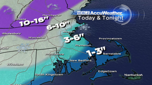
So it looks like a 3-commute nightmare - beginning during the Thursday morning commute, peaking during the Thursday evening commute and ending just before the Friday morning drive.

Here's an interesting wildcard for late Thursday night and early Friday morning...backlash snow. Backlash snow happens at the end of an event as upper level energy monopolizes any lingering moisture in the atmosphere and can create several more inches of snow and typically happens across interior New England in the hills and mountains. The coast is usually spared most of the accumulation due to the backing of winds to the NW which creates downsloping and additional drying of the atmosphere.
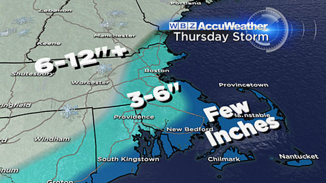
If the snow does arrive mid-morning on Thursday as we expect, this could be a situation where schools are forced to let out early in the middle of some very heavy snow.
It is much too early to project where this rain-snow line will setup and who will stay all snow, but, those areas that do not mix with rain could easily see 6-to-12 inches of snow or more.

Many awoke to fresh coatings of snow this morning as a weak system raced through Southern New England last night. The system had a little more punch in Northern New England and parts of the Maine coastline saw around half a foot of snow.
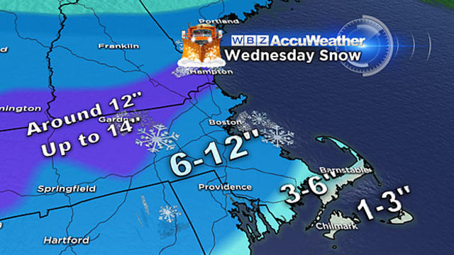
Most areas will get 8-to-12 inches of snow Wednesday and several towns will be reporting 9, 10 and 11-inch amounts.
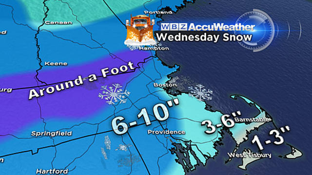
It will encompass all of New England, dump significant amounts of heavy, wet snow and impact both the morning and evening commutes.
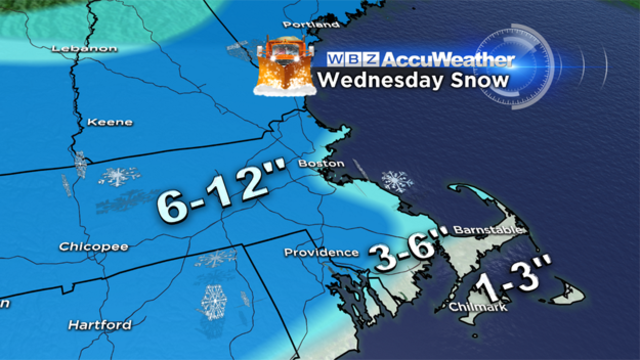
Here are the details about three storms that could hit the region this week:
Morning low temperatures bottomed out in the single digits...again...but the worst of the cold is behind us now and temps will moderate as we head into the weekend. A frontal system will stall over New England this weekend leading to a chance for rain or snow showers at times making it a bit unsettled but it will also lead to much milder air working in for a change

Too bad it's raining right now otherwise today would be pretty sweet as temps have shot up into the 40s ahead of an Arctic cold front. The rain showers will shut off this afternoon but gusty wind will transport in another round of Arctic air and we'll be in the deep freeze for the middle of the work week. Be careful driving or walking tonight...rain from today and a fast temp drop this evening will result in icy spots forming.

The snow will begin as early as 1 p.m. on Tuesday. The first to see flakes would be areas well to the south, along the South Coast, Cape Cod and the Islands.
Our Winter break is coming to an end...an arctic cold front will pass through this evening and temps will take a nose-dive.

Saturday's high was 59...Sunday's high was 54...today's high is expected to be 50 in Boston. That would make this a three day January thaw...kind of like a Winter heatwave! Whatever you want to call it it's been very nice but it won't last that much longer as with cold air expected to work back in later this week.

Wind is settling down temps are on the rise and we've officially turned the corner...on the road to an extended January thaw that rolls in this weekend! Much warmer air begins to work in tomorrow but it happens several thousand up...it won't work down to the surface until Saturday...it will lead to thickening clouds and snow breaking during the morning commute. The snow will be light but fairly steady and leave behind some coatings by midday.

We are right in the middle of the deep freeze but the worst is just about behind us and temps will begin a slow moderation through the rest of the week with an extended January thaw on the way.
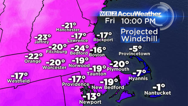
It is extremely cold out, wind chills are dangerously low. The kids may want to wait a day or two to hit the hills with their sleds or build the snowman.
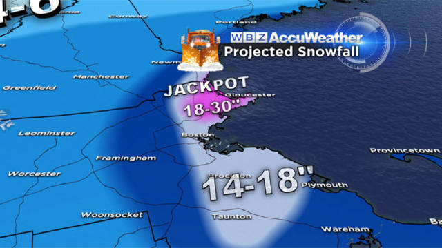
This is one of the coldest snowstorms in recent memory. Boston, Worcester and all points north and west are stuck in the single digits and dropping!
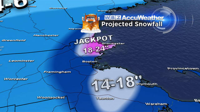
Nor'easter 2014 has arrived. It may take a while to get revved up but once we get there it is going to pack a significant punch.
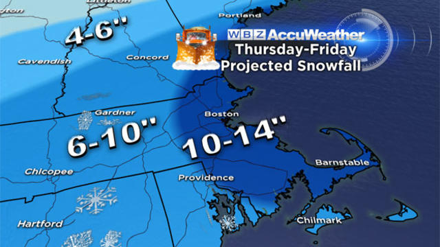
This will be a long duration event with nearly 36 hours of light to moderate snowfall.
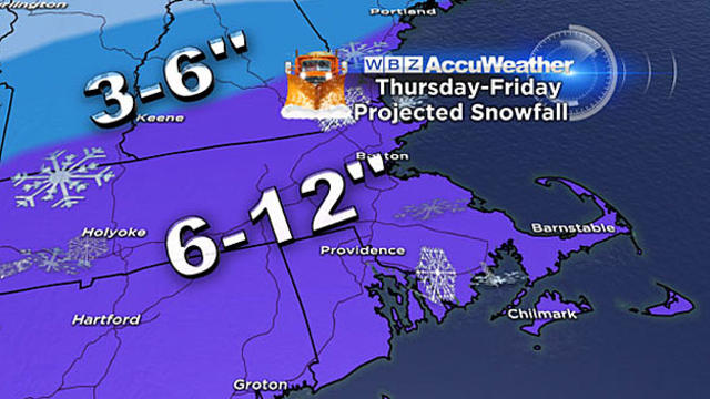
Our first true Nor'easter of the season appears to be on its way for later this week, but some good news as it appears we may skip a worst-case scenario.
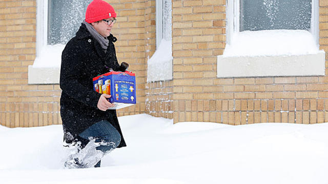
I would urge you pay a little extra attention to the forecast over the next 48 hours and be prepared for a rude welcome back to work and school from Mother Nature.

Enjoy today...30s don't sound that warm but they'll actually be the warmest temps of the week with an Arctic blast poised to arrive for the New Year. The first wave of cold arrives New Year's Eve night...just as the ball is dropping...temps are expected to be around 20 degrees with the wind picking up.
It will be a "Nor'easter type storm" that will bring about an inch of rain to southern New England.
The pictures from Northern New England are sad...major ice storm is ongoing for parts of Vermont, New Hampshire and Maine with power outages in the tens of thousands.