Snow And Rain Line Will Be A Close Call
Temperatures are so borderline that a difference of just one or two degrees could mean very little snow or several inches.
Watch CBS News
Temperatures are so borderline that a difference of just one or two degrees could mean very little snow or several inches.

Well, March seems to be a little mixed up this year. March came 'in like a lamb' and is going 'out like a lion'.
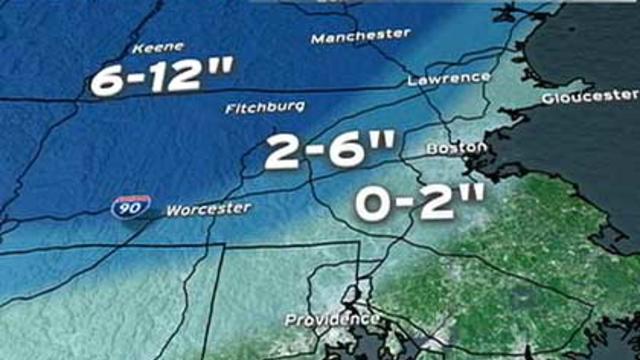
There will likely be a significant, heavy and wet snow in parts of northern Worcester County, all of western Massachusetts and in southern New Hampshire.
Today is going to be a sunny one with late-day clouds and highs in the upper 40s to lwoer 50s. With light west winds, a seabreeze will likely develop this afternoon which will cool off the coast.

There are signs that we could be in for a sizeable storm Friday. The problem is, many weather models are still having a tough time putting all the pieces together.
It's been cool since this past weekend, but we are now in the midst of a snail-like pace warming trend. Highs have the best chance of reaching 50F tomorrow and possibly on Thursday in select spots.

We are a very long way from Japan, so how did that radiation make its way half way around the world?
Today, the sunshine will prevail with temperatures rising into the lower 40s.
Sunny skies this morning will slowly fade behind building cumulus clouds, due to cold air aloft. A few of these clouds could spit out a flurry or two this afternoon. Highs will range between the upper 30s and lower 40s across southeastern Mass..
Besides a few snow showers this morning, mainly south of the Pike, we can expect a rather quiet day with mostly cloudy skies. Winds from the NNE will continue to usher in cooler-than-average high temperatures in the upper 30s to the lower 40s.
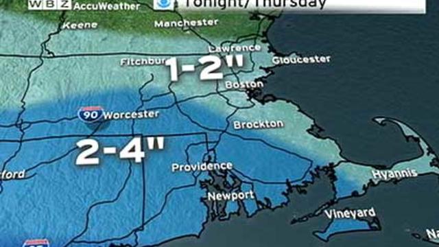
Most of us will wake up to an average of one-to-three inches of snow on Thursday morning. It will be more of a nuisance than anything else.
Peeks of sunshine this morning will lose grip as clouds continue to thicken this morning. Late-day light rain/snow will arrive across southeastern Mass late thi afternoon while it won't reach the northern suburbs until early tonight.
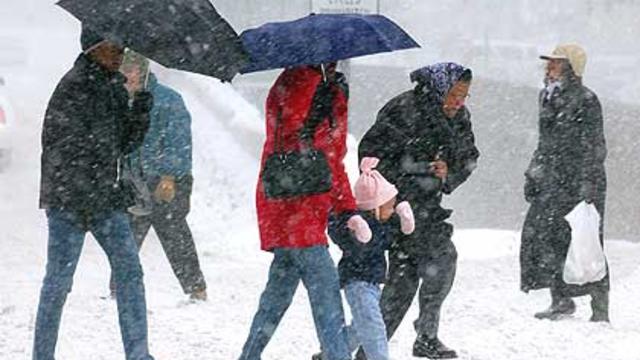
It's ironic that as we finally welcome spring that we revert back to a pattern similar to that one which caused us so much angst in mid-winter.
It's going to be a quiet day with increasing sunshine and high temperatures in the middle to upper 40s. Winds will be gusty at times from the north-northwest.
An area of low pressure will track across Southern New England today producing a plethora of precipitation. It should be a rain/snow mix from Boston to points south before transitioning to rain this afternoon. However, cooler temperatures for areas northwest of the city will continue to support mainly snow through the afternoon.
More clouds around this morning will give way to more sunshine later this afternoon. Highs will range from the upper 60s interior to the upper 50s/60 near the Cape/Islands.
Happy St. Patrick's Day! Morning fog, sunshine, and warm temperatures top today's weather headlines. Many interior areas will be flirting with 60F!
The rain will begin as a mixed variety for higher elevations of Central Mass and Southern NH. Otherwise, the rain will continue to develop and become moderate to heavy from midday thru mid-afternoon. An average of .50" of rain is expected to fall. The rain will taper by early evening providing us the chance to see a glimpse of sun before sunset at 6:51pm. Skies will gradually clear tonight.
Winter is going to go out 'like a lamb'. Besides a couple of chances of rain, this week will be fairly uneventful. Today will bring sunshine for all! Highs will range from the lower 40s along the coast to the upper 40s for Metrowest. Winds will shift to the southeast this afternoon.
Here we go. It's the last Monday for the Winter Season 2010-2011. It will be mostly cloudy and somewhat cool for a mid-March day. Highs will range from the upper 30s to lower 40s. There's a slight chance of a brief shower or flurry thry late afternoon as piece of energy at the 500H sweeps across New England.
Areas across Western/Central Mass and Southern NH may run into a few raindrops and snowflakes this morning. Otherwise, the main shield of rain will make gradual eastward progression through the day. Highs will reach the lower 40s in many areas today accompanied by an easterly breeze.
We will squeeze out another dry day today. Clouds will increase ahead of a storm system approaching from our southwest. High pressure centered to our north is producing a northeasterly breeze leading to cooler temperatures along the immediate coastline. Highs will range between 35-40F.
High pressure anchored to our northwest will produce north-northeast winds keeping temperatures at bay. Highs will reach the lower 40s with wall-to-wall sunshine.

Despite all of the recent rain, there is no major flooding expected except for some of the usual, flood prone areas.
It's warm and rainy this warming. The heaviest rain has already fallen, and the rain will continue to lighten and taper off around midday. Most areas will end up with 1-2" of rain with isolated spots up to 3".