
Isolated storms, showers that may prompt flash flooding on tap for North Texas
There will be high heat and humidity, with feels-like temps soaring above 100° for much of North Texas on Thursday.
Watch CBS News

There will be high heat and humidity, with feels-like temps soaring above 100° for much of North Texas on Thursday.

Temperatures are sticking in the mid to upper 90s for a stretch, but feels-like temperatures are even hotter, thanks to high humidity.

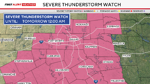
A cold front will move into North Texas Wednesday night, bringing the risk of severe weather and brief downpours.
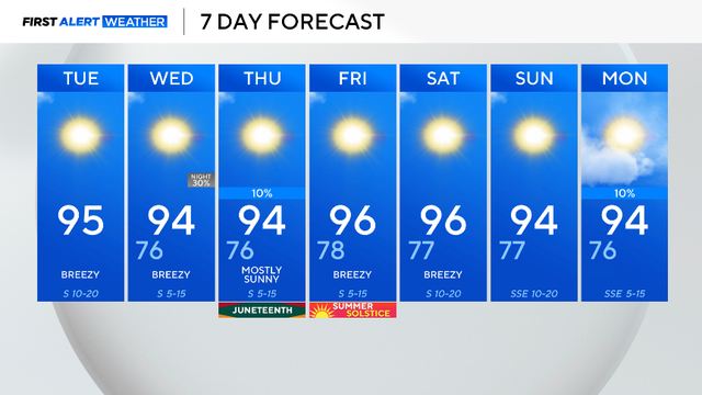
Highs in the mid-90s, lows in the upper 70s, and sunshine will be expected over the next several days.

After a morning of storms across North Texas, skies are clearing up and rain chances remain isolated.

Some residents woke to damage from Sunday night's storms that had winds up to 80 mph.

Environmental factors are extremely favorable for storm development.

Overnight storms cleared from Dallas-Fort Worth shortly after midnight, leaving flooding due to heavy rain their wake.

In the late-night hours, damaging winds and flash flooding are the highest risks.

Memorial Day weekend could be rainy.

A string of very nice days is ahead starting Tuesday. More unsettled weather returns by Sunday/Monday.

First Alert Weather Days have been issued for Sunday and Monday due to the severe weather threat.
The storm produced golf ball-sized hail and 60 mph wind gusts

A First Alert Weather Day remains in place Wednesday due to the dangerous heat.

A heat wave is on the way.