NEXT Weather Alert Day: Winter storm set to freeze southeast Michigan Wednesday


(CBS DETROIT) - A winter storm will bring hazardous impacts to southeast Michigan in the middle of this week.
Ice storm update ahead of Thursday morning commute
DTE Energy says "technical issue" is preventing outage, downed wire reporting
DTE Energy says on Wednesday a technical issue is preventing people from reporting downed wire, outages and gas leaks across its website.
This comes after an ice storm hits Michigan, causing hundreds of thousands of power outages across the state.
Ice storm on Wednesday impacts Michigan drivers
Michigan drivers braved the roads during Wednesday's ice storm.
"It's horrible out here, it's like an ice-skating rink," said driver, James Lee. "It's raining, it's snowing, it's sleeting. I mean name it, it's out here."
Click here to read more
Meteorologist Ahmad Bajjey gives update on ice storm
NEXT Weather Tracker Truck update for the evening of Feb. 22, 2023
Checking the weather along the I-75 corridor in Michigan
Tracking power outages amid winter storm in Michigan
With Southeast Michigan being hit with a winter storm on Wednesday, power outages are piling up in the region.
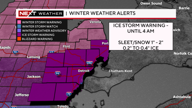
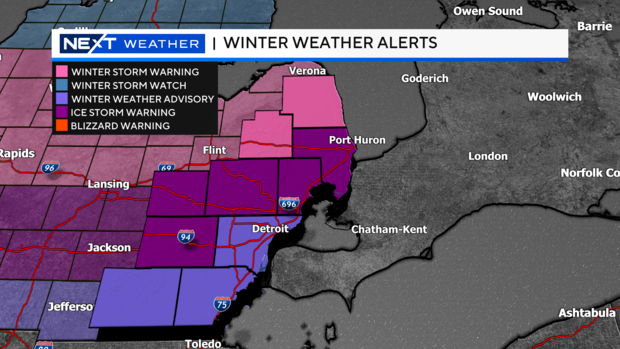
The National Weather Service issued an ice storm warning for Wayne, Lenawee and Monroe counties through 4 a.m. Thursday.
Read more here.
NEXT Weather evening forecast for Feb. 22, 2023
Ice storm warnings expand
Oakland County road crews set to salt 3,000 miles of road in Wednesday's ice storm
Oakland County road crews will be covering more than 3,000 miles of road, getting salt on pavements to make your commute more safe.
Wednesday's ice storm is keeping salt truck drivers busy around the clock.
Although 106 trucks are out clearing roads, officials are stressing drivers to not totally depend on the salt.
Read more here.
Winter storm update from Detroit Metro Airport
NEXT Weather Tracker Truck on Northwestern Highway
Meteorologist Ahmad Bajjey discusses freezing rain and road travel
Meteorologist Mike Seidel of The Weather Channel breaks down current conditions
MDOT prepares for winter storm
NEXT Weather Tracker Truck provides update on latest driving conditions
Michigan State Police 2nd District report ice building up on surfaces
Long-duration freezing rain moves across southeast Michigan
County road crews prepare for winter storm impacting southeast Michigan
Freezing rain happening along and south of US-12
Secretary of State offices closed in more than 20 counties due to winter storm
With severe winter weather expected across much of Michigan Wednesday, Secretary of State offices in more than 20 counties are closed.
The office locations are currently closed.
Allegan County (Allegan), Barry County (Hastings), Berrien County (Benton Harbor, Niles) Branch County (Coldwater), Calhoun County (Albion, Battle Creek), Cass County (Dowagiac), Eaton County (Lansing – Executive Court), Hillsdale County (Hillsdale), Ingham County (Lansing – East Michigan Ave., Mason), Jackson County (Jackson), Kalamazoo County (Kalamazoo, Portage) Lenawee County (Adrian), Livingston County (Howell), Macomb County (Chesterfield, Clinton Twp., Eastpointe, Romeo, Shelby Twp., Sterling Heights, Warren), Monroe County (Monroe, Temperance), Oakland County (Clarkston, Hazel Park, Highland, Novi, Oak Park, Pontiac, Rochester Hills, Southfield, Troy, West Bloomfield), St. Clair County (Port Huron), St. Joseph County (Sturgis), Van Buren County (Paw Paw), Washtenaw County (Ann Arbor, Chelsea, Ypsilanti), Wayne County (Belleville, Brownstown, Canton, Dearborn, Detroit – East Warren Ave, Detroit – Bagley, Detroit – Livernois, Detroit – West Grand Blvd, Detroit – Mack Ave, Detroit – West 7 Mile, Hamtramck, Inkster, Livonia, Redford, Taylor, Trenton).
Read more here.
CBS News Detroit NEXT Weather Team tracks winter storm approaching southeast Michigan
Winter system arrives
The NEXT Weather Team has been updating you about this winter system and now it's here.
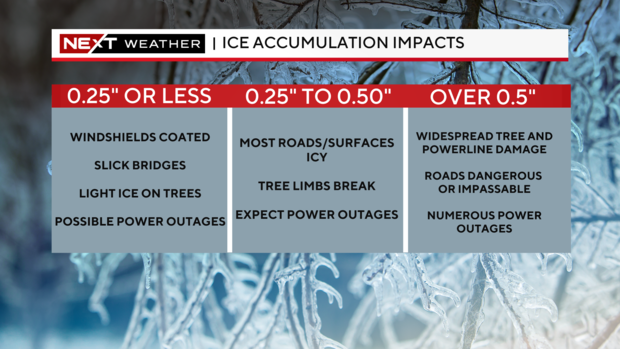
Ice Accumulation Impacts
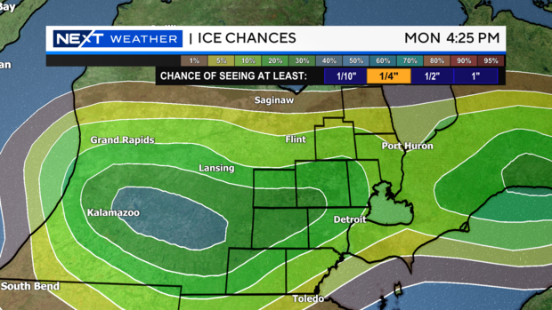
Ice accumulations are forecasted to range between 0.10" and 0.25" for most spots, with locally higher amounts near and between I-94 and I-96.
Significant impacts will be downed trees and powerlines.
NEXT Weather Forecast Feb. 22: Winter storm approaches
Meteorologist Kylee Miller tracks the winter system
Breakdown of Winter Weather Alerts
How much ice, snow, sleet, and freezing rain is expected in your area? We have the alert breakdown below.
What's in the NEXT Weather tracker? Meteorologist Ahmad Bajjey explains
Here's an update on upcoming winter storm
State of Michigan monitoring winter storm
Governor Gretchen Whitmer says the state is monitoring conditions as Wednesday's storm system approaches.
AAA provides roadside safety tips ahead of winter storm
Ahead of Wednesday's winter storm, AAA of Michigan is roadside safety tips for drivers.
AAA's Tips for Stranded Motorists on the Roadside
- Stay in the vehicle. Your car can provide shelter, allowing emergency responders to best locate you, and prevent you from being struck by an approaching vehicle. If you must get out of the car, ensure the surroundings are safe.
- To make the gas last longer, don't leave the car running. If there is an extended traffic jam, turn off the engine for a period, then back on to reheat the inside, when it has gotten too cold again. Make sure the exhaust pipe is snow-free.
- Avoid driving on the shoulders or medians of highways to get around the traffic jam. These need to be kept clear for first responders, tow trucks, and emergency vehicles to get to the cause of the stoppage.
- Cold weather can shorten the range of electric vehicles. EV drivers should plan for more frequent stops for charging and identify the location of charging stations before you hit the road. AAA recommends "pre-heating" the inside of your electric vehicle to a comfortable temperature while still connected to the charger. This will reduce the vehicle's battery demand to regulate cabin temperature at the onset of driving.
AAA Safety Tips While on the Road
- If you must be on the road, check the weather before setting out and change plans accordingly.
- Pack a well-stocked emergency kit with a cell phone car charger, first-aid kit; extra blankets, hats, gloves and coats; plenty of drinking water and non-perishable snacks for passengers, including pets; flashlight and extra batteries; reflective warning triangles; and an ice scraper or snow brush.
- Always drive at a safe speed that matches the prevailing visibility, traffic and road conditions – even if that means driving below the posted speed limit.
- Compensate for reduced traction by increasing your following distances (normally three to four seconds) to eight to ten seconds.
- Allow sufficient room for maintenance vehicles and plows, stay at least 200 feet back and, if you need to pass, go to the other vehicle's left
- Watch for icy surfaces on bridges and intersections, even if the rest of the road seems to be in good condition.
- Avoid braking on ice. If you're approaching a patch of ice, brake during your approach. Control the skid. Applying pressure to your brakes while on ice will throw your car into a skid
- If you get stuck in snow or ice, straighten the wheel and accelerate slowly. Add sand or cat litter under the drive wheels to help avoid spinning the tires.
- If your tires lose traction, continue to look and steer in the direction you want to go. If the drive wheels start to spin or slide while going up a hill, ease off the accelerator slightly and then gently resume speed.
- Slow Down, Move Over. Avoid driving on shoulders or medians so first responders, tow truck operators and emergency vehicles can get to stranded motorists who are in dangerous roadside conditions.
For more tips like these, click here.
Preparing your Vehicle for the Winter Road
If driving cannot be avoided, motorists can help keep their vehicles on the road safe by checking the following:
- Remove all snow and ice from car – This includes the hood, roof and trunk.
- Battery strength — Faulty batteries cause more car starting problems than any other factor. At 0 degrees, a good battery has 35 percent less starting power. Additionally, batteries that are 3-5 years old will have much less starting power in cold conditions.
- Tire inflation — Under-inflated tires can be dangerous, and may suffer damage. Tire air pressure decreases 1-2 psi for every 10 degree temperature drop.
- Wiper blades — The blades should completely clear the glass with each swipe. Replace any blade that leaves streaks or misses spots. In areas with snow, consider installing winter wiper blades that wrap the blade frame in a rubber boot to reduce ice and snow buildup.
- Washer fluid — Fill the windshield washer fluid reservoir with a winter cleaning solution that has antifreeze components to prevent it from freezing.
First Ice Storm Warning for southeast Michigan in years
The Ice Storm Warning issued by the National Weather Service in White Lake is the first one issued since January of 2020.
For the western side of Michigan, this is the first ice storm warning in more than nine years.
Ice Storm and Winter Storm Warnings issued
Winter Storm and Ice Storm warnings have been issued by the National Weather Service.
Winter Weather Advisories begin at 10 a.m. Wednesday for Lenawee, Monroe, and Wayne counties.
Ice Storm Warnings begin at 12 p.m. Wednesday for Livingston, Macomb, Oakland, St. Clair and Washtenaw counties.
Winter Storm Warnings begin at 12 p.m. Wednesday for Lapeer and Sanilac counties.
Total snow and sleet amounts are expected up to two inches with freezing rain ice near a quarter of an inch in some of the heaviest areas.
Near a tenth of an inch of ice for those outside the ice storm area.
Have your emergency kit ready to go Wednesday
Winter weather-maker on tap for southeastern Michigan
Winter storm set to impact southeast Michigan
After a quick coating of snow, we'll make a change at the start of the evening commute (around 5 p.m.) over to sleet or freezing rain, or possibly both.
This change will significantly depend on the temperature we experience not just at ground level but also higher up.
As the evening goes on, we will see freezing rain and sleet as the dominant precipitation types leading to hazardous travel on ice covered roads.
As the night progresses these precipitation types begin to also see rainfall mix in especially south of I-94.
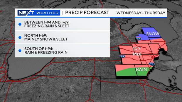
This means the primary corridor for ice coverage would be between I-94 and I-69.
Shifting with a system like this is common, which is why these layers are so broad right now.
With that being said, plan for hazardous travel at least on Wednesday evening through the morning hours on Thursday, and likely longer on roads that won't receive treatment right away.
Some power outages are possible due to the weight of ice on spans.
Half an inch of ice on a normal residential span can add more than 500 pounds to the weight of the line.
Wind plays another factor where a stronger breeze adds on to weaken power lines or tree branches.
Our best chance at a quarter-inch of ice remains in the central/western portions of southeast Michigan while the most likely spots for more would be from Jackson to Battle Creek (shown in the blue circle).
Our primary forecast concern that gives us a little pause would be the freezing line.
This is the area in the atmosphere that will be draped west to east across the region that is the divide between rain and cold precipitation.
Over the next 24 hours we'll get a much better idea on where specifically that line will set up and how it will move through the region.
Where that motion occurs is where you can expect the change from snow to sleet to freezing rain and then eventually rainfall.
Another factor is rainfall intensity and rainfall rate.
The heavier the rain falls the warmer the air gets around it and if this happens it would cut down on our ice amounts.
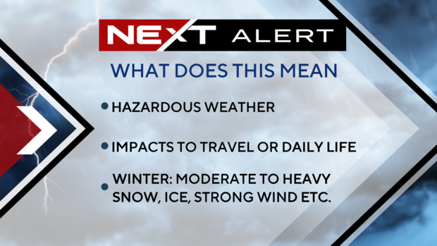
In anticipation of this system and the likely travel impacts we are declaring Wednesday as a NEXT Weather Alert Day.
This means we will be increasing our weather coverage in all shows, online, on our stream, and on social media.
We will also have crews in the field, including in our NEXT Weather Tracker vehicle, keeping an eye on conditions and taking readings that we use to continuously forecast the event.
Alert Days are only declared by us when hazardous weather is expected to impact travel or regular daily life, and it must meet a higher criteria than normal storm systems.
For example, we wouldn't issue this on a day where we get a couple of inches of snowfall.
Plan ahead now for hazardous travel during the late-afternoon and evening on Wednesday through the morning hours on Thursday.
Stay with the CBS Detroit NEXT Weather Team for the latest on the evolving forecast.
Update on winter storm approaching 2-21-2023
(CBS DETROIT) - Anywhere north of I-69, expect mainly snow will snowfall accumulations coming in generally around 2 to 4 inches.
For Monroe and Lenawee counties, this will mainly be a rain event, however, the rain will be heavy at times, and you may even hear a brief rumble of thunder.
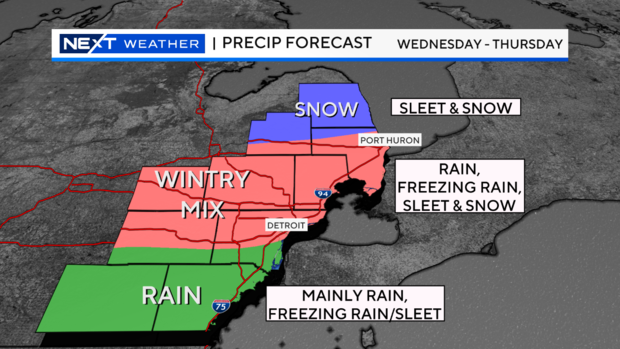
We are looking at around an inch of rainfall in these areas which could cause flooding. Plus, all the standing water may freeze over at night. Some minor icing may happen also, with some freezing rain at times of the evening and overnight.
Locations between I-94 and I-69 have the best likelihood of freezing rain, rain, and sleet. This is all temperature dependent, high up in the atmosphere and near the surface which will help distinguish what type of precipitation we get and when.
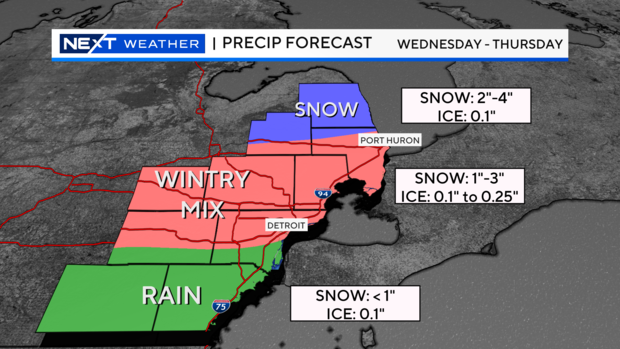
We could get up to 0.25" of ice accumulation. This could easily break tree branches and powerlines, so we will keep you updated if and when those numbers come in.
Your NEXT Weather team will continue to fine-tune the forecast as we get closer.


