Feels-like temperatures to reach 109 in North Texas as heat advisory persists this week

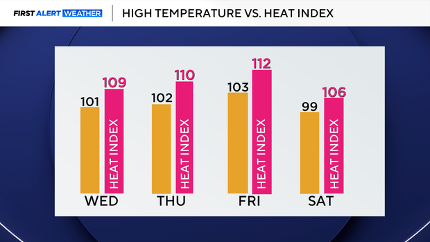
The heat advisory has been extended through at least 8 p.m. Thursday, and further extensions in the upcoming days are likely. Friday will be the hottest day with heat index values between 110 and 115°, with the potential of an excessive heat warning being issued.
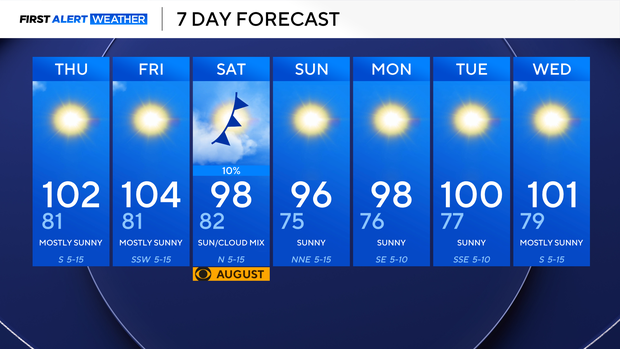
Temperatures will remain in the triple digits through the start of the weekend, with heat index values between 105-110°. A weak cold front enters the area early Saturday morning, but no significant cooling is expected Sunday through Monday with temperatures in the upper 90s.
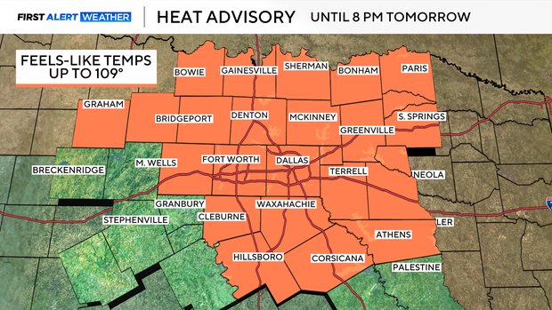
With moisture coming in from the Gulf, it's making it feel hotter than it actually is outside.
Nighttime temperatures will struggle to cool off throughout the week and they will remain in the low 80s across the area.
Moving into the latter part of this week, temperatures will progressively warm, and the heat index will rise to as high as 115° by Friday. With the ridge of high pressure nearby through Friday, no rain chances in the forecast, as we stay hot and mainly dry. This day will have the highest chance of an excessive heat warning being issued for the area, and if so, a First Alert Weather Day will be needed.
The ridge of high pressure will move off to the west into portions of the Desert Southwest, this will open the door for a northwest flow aloft to enter the area and sneak in a weak cold front early in the morning on Saturday with a slim rain chance early.
After this front passes, temperatures will hover in the upper 90s through Monday, with no noticeable relief expected. This will be brief as we enter the month of August with temperatures back into the triple digits by Tuesday.