Chicago First Alert Weather, warmer tomorrow, shower chances Thursday into Friday
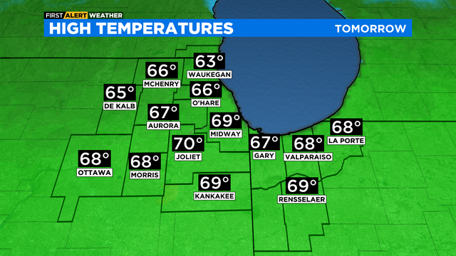
Tomorrow a warm, southwesterly flow develops, carrying temperatures well above average into the 60s.
Watch CBS News
Tomorrow a warm, southwesterly flow develops, carrying temperatures well above average into the 60s.

The six to 10 day outlook from the Climate Prediction Center highlights warmer than normal temperatures next week.

The warmup continues through the next week.

The warm-up has begun. 50 today, and mild next week.

Get ready for the warm up! We're headed for 50s and 60s most of next week!

A cold start to the weekend, but there's a big warm-up on the way.

Strong northwesterly winds took over Friday night, pulling in a bitter cold air mass.

Light snow continues overnight, with it tapering off early Friday morning.

Dry and quiet through tonight with lows falling into the lower 20s.

Our next snow chance arrives after dark Thursday into the night.

The low drops to 22 Monday night with slow clearing.

After leaving us 1" to 3" of snow, our weather system departs, leaving a chilly northwest wind flow for the rest of the day.

Sunday night brings in that wintry mix including rain, sleet, snow and freezing rain.

After yesterday's Spring temperatures and last night's Spring storms, winds are bringing in much colder air today.

Severe thunderstorms and isolated tornadoes are possible in the Chicago area.

An active weekend with ups and downs, and a few storms this evening.
It will be mostly cloudy with temperatures holding steady overnight through Saturday morning in the upper 30s and low 40s.

Partly to mostly cloudy skies this afternoon with highs in the low to mid-40s. Upper 30s and low 40s tonight with a breezy southeast wind.

A strong south wind will push highs on Saturday to the highest levels so far this year.