Hint of Spring
The winter chill is still in the air today.
Watch CBS News
The winter chill is still in the air today.
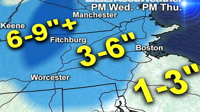
Winter Storm Warnings and Winter Weather Advisories will take effect this afternoon. It all begins around 2 p.m. and lingers through Thursday night.
Winter Storm Warnings and Winter Weather Advisories will take effect this afternoon. It all begins around 2 p.m. and lingers through Thursday night.
Today will be a beauty in the wake of a cold front. The sun will be shining, and the wind will be breezy from the northwest as colder air seeps into the region. High temperatures will be between 40-45F.
A storm system heads this way on Wednesday and Thursday.
Winter is making a short-term appearance starting today. This morning is the first wave of precipitation which will be a plethora of precipitation...rain, sleet, and snow before transitioning to all rain. This 1st wave will move out ~9am, so the precipitation will taper through midday.
The current orientation of the jetstream has positioned us within the 'line of fire'. It's a progressive flow so these disturbances are in and out rather quickly.
The pinnacle of this warm stretch will be TODAY instead of Friday! So, get outside and enjoy the springlike warmth! :)
It's Fat Tuesday! Mild air is starting to work its way into Southern New England. Highs were near 40F yesterday, and you can add on 5F degrees (45F) for today's high temperature. It's going to be a bright, bright, bright, bright, and sunshiny day!
The Vernal Equinox is just one month away! Beginning in July 2011, average temperatures have been above normal. We are doing it again this month. So far this month, we are running ~5.5F above average.
We are going to squeeze out another mild day with temperatures approaching the 50F degree mark. A few showers will linger on the cold front that will head offshore between 8am-12 noon.
We will see a glimpse or two of sunshine this morning before clouds take over. As a low pressure system and its accompanying cold front near the region, light rain showers will develop this evening after 6pm.
A weak shortwave is producing cloud cover and a few sprinkles and flurries around the area this morning. Clouds will continue to blanket the sky for most of the day. There may be a peek or two of sunshine before sunset (5:16pm) as clouds begin to deteriorate. Highs will reach 45-50 degrees this afternoon along with a light breeze.
We are going to 'heat' things up this Valentine's Day. Clouds will blanket the sky with a weak shortwave in the vicinity while temperatures climb into the 45-50F range.
Sunday was a chilly day with wind chills in the single digits and teens. Today, temperatures are upward bound as they approach 'seasonal' territory. Highs will return to the middle and upper 30s this afternoon, but breezy west winds will add the 'chilly' touch.
Yes, SNOW has become a rare commodity this winter season. It's that rare commodity that is heading our way on Saturday. Until then, the sun will be shining and working hard to warm our high temperatures up to 50F! It's going to be a gorgeous February day!
We are currently in the midst of a 2-day warming trend. The sun will be shining and temperatures wil return to the middle 40s today. Tomorrow will be another sun-filled day with highs flirting with 50F! Clouds will begin to blanket the sky on Friday evening.
It's quite cold outside this morning as some of the 'burbs have fallen into the teens. The sun will rise ~6:50am providing us a bright sky initially. However, that won't be long-lived as clouds will continue to take over the sky.
It's another uneventful day for New England. A dry cold front is working through our region which will open the doors to colder air to travel into our neighborhoods. Temperatures will top off in the lower and middle 40s today, but the colder air will work its way southward on Wednesday.
'Back and forth' describes the temperature this winter. We have a shot of cold air followed by the return of mild air within a day or two. The peaks and valleys have had lower wave heights (not as drastic temperature swings) and have had less frequency when compared to an average New England winter.
Quiet, quiet, all is quiet... That's the forecast as we head into Super Bowl weekend and into the middle part of next week.
Every year, we sit on the edges of our seats as we await Punxsutawney Phil's 126th winter prognostication...6 more week of winter? Okay, maybe we aren't 'chomping at the bit', but it's a day to break up the monotony of winter. However, unless you're a winter weather enthusiast, this winter has been a 'breeze'.
What a way to make an entrance! We are in the midst of Winter on this February day, and high temperatures are aiming for the 50s! Average highs are now on the uphill swing.
It's an uneventful end to the month of January. A few benign flurries and snow showers (mainly north and west) will lead the way to a brighter sky this afternoon. There will be more clouds to the north as the warm front is taking its time as it travels northward. Highs will be in the lower 40s north and west to the middle 40s in the city to the upper 40s for the Cape/Islands.
A 'Clipper-like' system is moving through this morning, which is inducing a few light rain and snow showers. Skies will become mostly sunny afterwards. West-northwest winds will be gusting up to 30 miles per hour. High temperatures will be in the 35-40F degree range.