Snow chance in NYC this weekend during brutally cold stretch. Here's how much is in the forecast.
This brutally cold weather stretch in the New York City area means business — especially with snow increasingly likely in the coming days.
Thursday was cold and blustery around the Tri-State Area, with wind chills making it feel like the 20s — even the teens and single digits in some parts of New York, New Jersey and Connecticut.
Friday brings more of the same: cold and breezy conditions with highs in the 30s.
Brutal cold weather stretch
Friday morning kicks off frigid and breezy, with wind chills in the teens — or even single digits in some spots. By afternoon, temperatures climb into the 30s, but don't let that fool you. With the breeze sticking around, it will feel more like the 20s.
Tonight brings a slight break from the wind, but the cold isn't going anywhere. Expect calmer conditions with wind chills in the 20s.
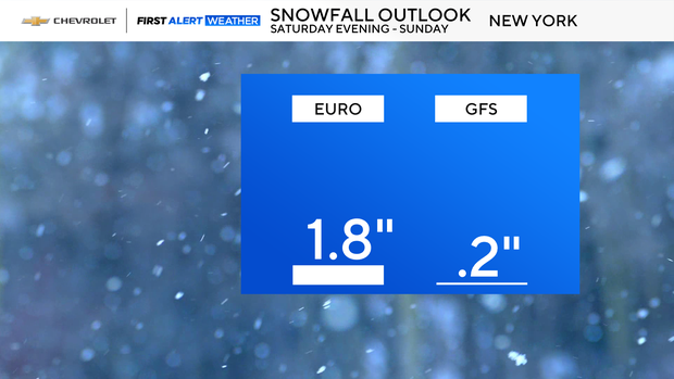
How much snow this weekend?
Looking ahead to the weekend, Saturday starts off quiet, but late-day rain and snow move in. At night, light to moderate snow will overspread the area.
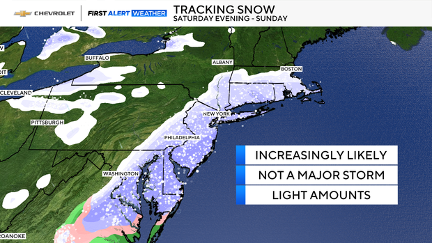
And by Sunday morning, we'll likely have 1 to 3 inches on the ground — Central Park's first measurable snow, if everything goes according to plan.
After that, temperatures tumble through the day, and by afternoon, it will only feel like the teens.
Sunday evening, as Hanukkah begins, conditions stay very cold and breezy. Wind chills will linger in the teens, so if you're heading out for celebrations, plan for extra layers and maybe a warm drink in hand.