Winter storm timeline for New York, New Jersey shows when heaviest snow hits today
People in New York City and the surrounding area are bracing for a major winter storm that's hitting the region Sunday with expected heavy snow on top of dangerous, subfreezing weather.
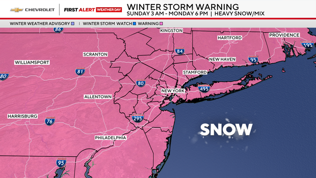
New York, New Jersey and portions of southern Connecticut are under winter storm warnings, prompting all three governors to declare a state of emergency, with the forecast calling for 12 inches or more in parts of the Tri-State Area.
The first snowflakes started falling in New York City at around 5 a.m.
Gov. Kathy Hochul activated the New York National Guard to assist across NYC, Long Island and the northern suburbs during the snowstorm, which could be the city's worst since February 2021.
Mayor Zohran Mamdani told New Yorkers to expect "whiteout or near-blizzard" conditions at the height of the storm.
New Jersey Gov. Mikie Sherrill announced NJ Transit suspensions on top of speed and travel restrictions on major highways.
When will it start snowing?
Winter storm warnings are in place for the NYC area from 3 a.m. Sunday-6 p.m Monday.
Snow arrived in the early hours Sunday. It will become quite heavy at times, for at least six to eight hours.
Here's how the storm timeline shapes up:
3 a.m.-7 a.m. Sunday: As a potent winter storm travels northward, snow moves into our region from west to east. It will start off light and then become moderate towards daybreak.
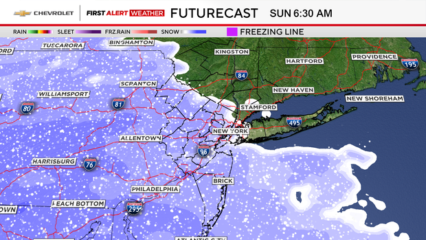
7 a.m.-2 p.m. Sunday: Snow becomes very heavy and may fall at rates of 1-2 inches per hour.
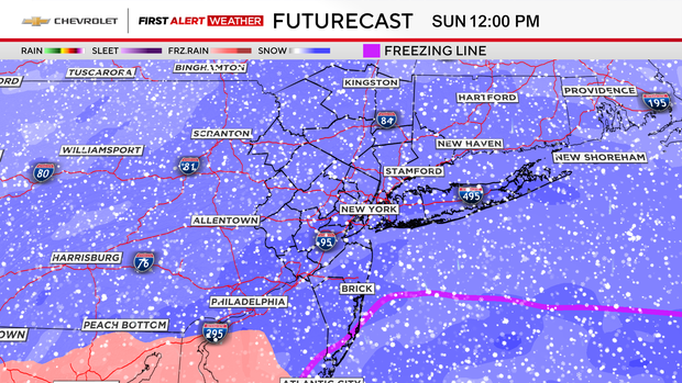
2 p.m-10 p.m. Sunday: As warmer air gets drawn into the system, the freezing line shifts northwestward, changing the snow to a mix of freezing rain and sleet for NYC and points south and east. Plain rain is likely for the Jersey Shore and South Shore of Long Island. North and west of the city, it's still all snow, and it's heavy too.
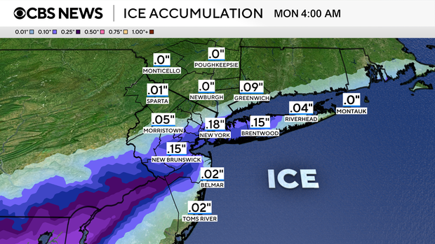
Winds will also increase, especially at the coast, gusting between 25- 35 mph at times. This would create near blizzard conditions. Ice accretion could reach up to .25 inches during this time frame and may lead to downed trees and branches when mixed with the winds. Although not a major concern, some minor coastal flooding and beach erosion are possible along the coastline as well.
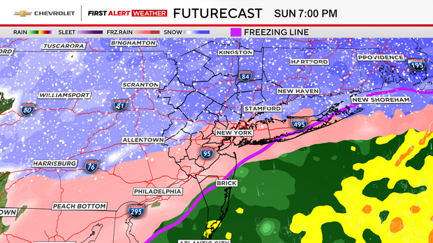
10 p.m. Sunday-7 a.m. Monday: Precipitation transitions back to snow for everyone. The storm starts winding down, and the snow becomes light to moderate at times. It may linger into Monday afternoon, though.
How much snow is NYC getting?
Even though the period of mixing will likely hamper snow totals in many locations, it's still possible that those places will measure 1 foot of snow. This is due to the snow coming down so heavily initially, as well as the ground being frozen. The cold air is then expected to stay in place through the beginning of February, ensuring that whatever snow falls this weekend will stay on the ground for a while.
If New York City manages to receive 12 inches or more with this storm, it would be the first time since February 2021.
In general, areas north and west of NYC are most likely to see over 12 inches of snow. In and around the five boroughs could see 8-12 inches, while locations along the coast may only see 5-10 inches.
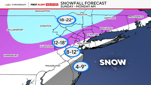
Here's a look at the snow totals forecast for the region:
New York City: 8-12 inches
Long Island: 8-12 inches for the North Shore and western portions. The South Shore and eastern half are more likely to see 4-9 inches.
Central Jersey and Jersey Shore: 8-12 inches inland, 4-9 inches along the coastline.
North Jersey, Lower Hudson Valley and Connecticut: 12-18 inches
Upper Hudson Valley and far northwestern New Jersey: 18-22 inches