North And West Of Boston To See Most Snow From Weekend Storm
This storm will be very different from the last two, mainly because it will be a warmer storm.
Watch CBS News
This storm will be very different from the last two, mainly because it will be a warmer storm.

What we know is that a coastal storm will be hitting New England. What we don't know is how far north the rain-snow line will set-up on Saturday night.

All is quiet yet very cold in the weather department today. Partly sunny skies will prevail with blustery conditions that will make it feel even colder than the actual reading on your thermometer.

This pattern looks as though it will continue for at least one more week as we are eyeing what might be yet another plowable snowfall this weekend.
It was a nice day yesterday as highs temperatures reached the middle to upper 40s. Today will be the end result of the passage of a cold front. Cold air is working in as we speak.
It's going to be a pleasant start to the day before rain arrives later in the afternoon, specifically after 2pm.
The models are hinting at a few snow showers on Saturday, but now the time period that we are focusing on will be Saturday night into Sunday morning.
Happy Valentine's Day! The snow/mix moved in quickly overnight, and it's going to move out just as quickly this morning. The sky cover will be described as mostly sunny on this day for lovers along with high temps in the lower 40s.
Today will be a dry one with fading sunshine late in the day. Winds will be light from the west, and high temperatures will hang around the 40F mark.
The track of a storm from Wednesday night through Thursday morning is still questionable.
It's two days after ther Blizzard of '13, and there are still secondary roads that are snow covered and even main roads have some right lanes covered with tall snowbanks. It is going to be a slow drive into your morning destination.
We did it! We made history! Boston recorded the 5th all-time snow event since records began (24.9"). In Worcester, the Blizzard of '13 is penciled in as the 3rd all-time snowiest event on record (28.5"). Now, let the clean-up begin!!!

Clearly this is not a storm to be taken lightly. If you have not already completed your storm preparations you should do so immediately.

A few ocean-effect snowflakes will be around this morning just to lead the way to the huge storm that will 'bomb-out' by this evening.
The two storms are getting ready to phase into one massive storm. This storm will be the culprit of heavy snow, potential moderate to major coastal flooding, adn tropical storm to hurricane force wind gusts~ This storm will literally 'pack a powerful punch'!
We are still expecting a widespread 18-to-24 inches or more from this storm, with some isolated areas possibly getting 30 inches.

This could turn out to be a top 5 snowstorm for Boston. There have only been 6 other storms (on record since 1892) when Boston has received 20+ inches of snow from one storm.
All of the pieces are starting to come together for a potentially historic Nor'easter for Southern New England.
The snowstorm Friday will be big, but will it be historic and rival some of the legendary storms of Boston's past? The short answer is it just might.

Each model now shows significant snowfall impacting southern New England, with the heart of the storm occurring from Friday evening through early Saturday morning.
Some light snow has fallen overnight creating slick neighborhood streets, sidewalks, and parking lots. Please drive and walk carefully.

There will be no hype here, just the plain old facts as we see them right now, about 72 hours ahead of any sort of storm on Friday.
After breaking a couple of record highs in Worcester and flirting with record highs in Boston, today will be an abrupt change for your body. It will be colder in terms of the actual temperature as well as the wind chill.

We are in for one heck of a ride in the next 24-48 hours, the classic New England-style roller coaster complete with warnings signs and all.
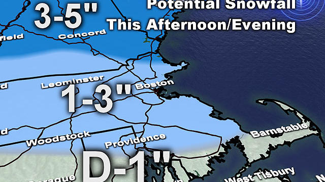
A second wave of precipitation will likely keep roads a bit hazardous piling some ice on top of the fresh snow.