Rain, freezing temps to create messy commute Thursday in Philadelphia, storm moving out by midday


Click here to see a full list of school closings and delays for Thursday, Feb. 6, 2025.
The Philadelphia region is bracing for a busy middle and end of the week when it comes to weather.
The Thursday morning commute we may likely have rain, snow, freezing rain and sleet — all at the same time somewhere in our area. By the midday hours, it should all change over to rain, delivering an inch or more in spots, especially north into the Lehigh Valley and the Poconos.
This weather is causing slick conditions and reducing speed limits on some major roads, and has contributed to over 100 flight cancellations at Philadelphia International Airport.
Here's a breakdown of when you can expect snow:
Timing of storm in Philadelphia region
Midnight – 2 a.m.:
- Temperatures will be on either side of freezing across the area.
- The surface streets and elevated surfaces will be at freezing, allowing for a combination of sleet and freezing rain over Southeastern Pennsylvania, including Philly and much of Northern Delaware and South Jersey.
- Less than a tenth of an inch of ice is possible.
- Farther south and east over Southern Delaware and far South Jersey, temperatures will be above freezing with any frozen precipitation changing to rain.
2 a.m. – 7 a.m.:
- Heavy freezing rain is mixing with sleet, especially from the city and spots to the north – wherever temperatures are just above or below freezing. A mix of sleet, snow and freezing rain is falling in the Poconos and Lehigh Valley.
- This period is when we see the greatest accumulation of ice and sleet on surfaces.
- Temperatures in South Jersey and Delaware will be in the mid and upper 30s with rain.
- Icing is most likely on elevated surfaces like bridges and overpasses.
- Car doors could be frozen shut. If possible, place a hand towel on the door handle and a snow mat or towel on the windshield to peel ice away faster in the early morning.
- Avoid throwing hot water on windows or windshields. That can cause the glass to crack.
7 a.m. – 9 a.m.:
- Temperatures will be in the mid to upper 30s with rain across the entire area EXCEPT the Lehigh Valley, Poconos, Berks and Upper Bucks and Montgomery Counties. That's where scattered areas of sleet and freezing rain will still be possible.
- For the rest of us, a line of rain will be pushing north from Delaware and South Jersey into the city and more southern suburban counties like Chester and Delaware, and lower Bucks and Montgomery counties - as well as Mercer County, New Jersey.
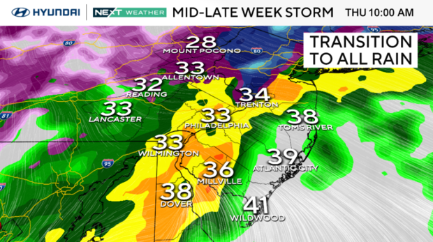
10 a.m. – Noon:
- At this point, the rain will move out from west to east.
- The entire area will be above freezing with low to mid 30s in the Lehigh Valley, mid to upper 30s along I-95 and Philly, and temps in the 40s across South Jersey and Delaware.
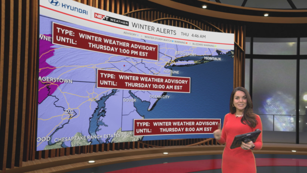
Winter weather advisory alerts in effect around Philadelphia area
The snow, followed by freezing rain and sleet, will compact on the roadways, especially north and west of the city. This "layering" is like lasagna — except the result isn't as nice, with a freeze and refreeze on the roadways that could cause issues if you're trying to navigate the commute Thursday morning.
A winter weather advisory was in effect for the entire region but expired at different times depending on where you live.
The advisory expired at 8 a.m. for Delaware and the Jersey Shore — and at 10 a.m. in Philadelphia, South Jersey and southeastern Pennsylvania. Farther north in the Lehigh Valley and Poconos, the advisory expired at 1 p.m.
Budget plenty of extra time Thursday to get around, and most importantly, take it slow.
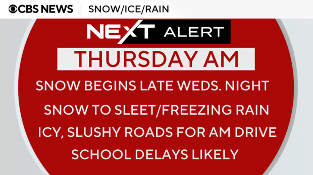
Needless to say, travel conditions will not be ideal, and the potential for morning school delays is in the conversation. Make backup plans now if this impacts your family.
The precipitation will end by Thursday evening. By Friday, the skies will clear, and temperatures will once again be in the mid-40s.
Then, we track yet another potential winter system set to deliver some snow or snow-rain mix on Saturday, mainly later in the day and leading into Super Bowl Sunday. This system will end as rain once again, repeating a similar pattern to what we'll see early Thursday.
Super Bowl forecast in New Orleans, Philadelphia
This forecast will evolve, so stay tuned.
In New Orleans, fans will enjoy the game in the dry, temperature-controlled Superdome. Outside temperatures will be in the 70s with increasing clouds.
In Philadelphia, we could see rain or snow or a mix, especially in the morning, with the tail end of a system that will bring a wintry mix starting Saturday night.
Get the latest weather info on the CBS News Philadelphia app.


