How many inches of snow are expected today around NYC, N.J. and Long Island? Maps show projected totals
Editor's note: Check the snow totals here. Below you can see our forecast prior to the storm.
NEW YORK -- The New York City area has three snow chances this week, but how many inches are expected to stick?
A First Alert Weather Day is in place Wednesday morning due to accumulating snow that led to school closures and delays and could disrupt the morning commute.
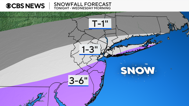
This system was expected to bring as many as 3 to 6 inches of accumulation to parts of New Jersey, 1 to 3 inches for New York City and Long Island, and a trace to an inch for places farther north.
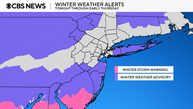
The National Weather Service issued a winter weather advisory for all of Long Island, as well as Monmouth and Ocean counties from 7 p.m. Tuesday to 7 a.m. Wednesday.
New York City's Emergency Management Department also issued a weather alert over the snow and freezing temperatures.
"New York City is expecting two rounds of winter weather, with snow expected Tuesday night and again Wednesday night, potentially lingering into Thursday," said Commissioner Zach Iscol said in a statement. "New Yorkers should stay informed by closely monitoring forecasts and subscribing to Notify NYC for emergency alerts. Make sure you're prepared for potentially slippery conditions and exercise caution while traveling, prioritizing mass transit when possible. We also urge everyone to check on their neighbors, especially those who may need extra support in the days ahead. With Code Blue activated, the City is also working to protect our most vulnerable residents. If you see anyone in need of shelter, please don't hesitate to call 311."
Nassau County officials say they'll begin salting the roads around 8 p.m. Tuesday.
"Depending upon how many inches of snow we receive, then we will have the plows go out to make sure that all 80 of our trucks are out and operating and that all of the county roads are clear by the time we commute tomorrow around 7 a.m.," Nassau County Executive Bruce Blakeman said.
The next round moves in Wednesday evening into Thursday morning, followed by the final round Saturday afternoon. Sullivan and Ulster counties will be under a winter weather advisory for Wednesday night's round of wintry precipitation.
None of these storms are poised to produce significant amounts of snow by any means, but they will disrupt travel and lead to dangerous road conditions at times.
Storm 1: Tuesday night into Wednesday morning
The first of three storms poised to impact the region over the next several days is now wrapping up. Snow totals will start coming in soon from across the Tri-State.
Due to the storm's track shifting slightly to the north, forecast totals went up for the southern shore of Long Island, where they joined Monmouth and Ocean counties in the 3 to 6-inch range. As for New York City, the north shore of Long Island, most of northern New Jersey, southern Connecticut, as well as the extreme southern Hudson Valley, a general 1 to 3-inch range was expected. To the north of these areas, only a trace to 1 inch was likely to fall.
Storm 2: Wednesday night into Thursday morning
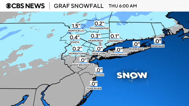
After a very brief break on Wednesday afternoon, yet another storm rolls into the region for Wednesday night into Thursday morning. Unlike the first storm, this one will have a blend of wintry precipitation associated with it. Precipitation begins as snow on Wednesday evening, with a quick changeover to a mix of sleet, freezing rain and rain by Wednesday night, followed by a transition to plain rain in the early hours of Thursday morning. Before the changeover, a quick accumulation of 1-2 inches of snow is expected for areas well to the northwest of the city.
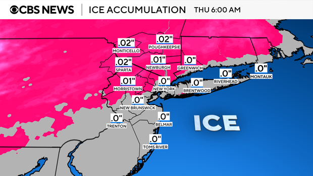
Of most concern with this storm would be the potential for a few hundredths of an inch of ice accretion from the freezing rain. The northwestern suburbs have the greatest chance of this occurring. After the changeover, plain rain could last into early Thursday afternoon. Temperatures will then surge into the 40s, which would melt any frozen precipitation that falls between now and then.
Storm 3: Saturday afternoon
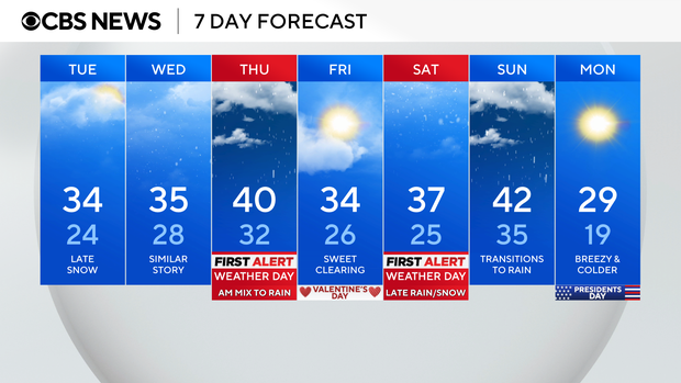
In the wake of the second storm, a full day of quiet weather is forecast for Friday. This respite won't last long though, as the third storm in line infiltrates the region by Saturday evening. In contrast to its predecessors, this one is not expected to contain much in the way of frozen precipitation.
At its onslaught, a brief period of snow, sleet and freezing rain can be anticipated. As warmer air from the south gets entrained into the storm, a quick changeover to plain rain will occur by Saturday night. Rain will then linger into Sunday, with totals near 1 inch in many locales.
Live radar around Tri-State Area
Stick with our First Alert Weather team for the latest forecast, live radar and weather alerts.