Snow-rain mix on tap Wednesday night for New Jersey, New York and Long Island
NEW YORK -- The first of multiple storm systems hit the New York City area Tuesday night into Wednesday morning, bringing with it more accumulating snow to parts of our area.
So, who got the most, and what should we expect from the next storms?
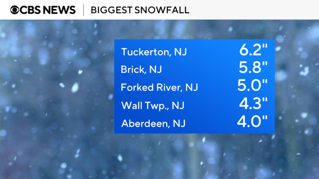
N.J. snow totals
Parts of New Jersey saw significant snow totals from the fast-moving storm. And there's more yet to come.
- Cape May, N.J. got 8.8 inches
- Tuckerton, N.J. got 6.2 inches
- Brick, N.J. got 5.8 inches
- Forked River, N.J. got 5.0 inches
- Wall Township, N.J. got 4.3 inches
- Aberdeen, N.J. got 4 inches
Snow in NYC, Long Island and beyond
There was less accumulation in New York City and on Long Island. The city, with 11.6 inches of accumulation so far this winter, is about 7 inches below the average for this time of year.
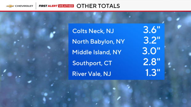
- North Babylon on Long Island got 3.2 inches
- Middle Island got 3 inches
- Canarsie, Brooklyn got 2 inches
- New York City's Central Park got 1.5 inches
- The Bronx's Fordham neighborhood got 1.3 inches
More winter storms on the way
The next storm system moves into our area Wednesday night into Thursday morning. And on the heels of that, you can expect even more winter weather Saturday afternoon. The good news, though, is that these storms aren't expected to produce a significant amount of snow, but they will be enough to potentially disrupt travel and create treacherous road conditions.
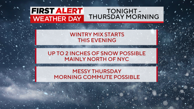
Wednesday will bring us winter temperatures with some late snow and rain mixing. The high will be 35 degrees. The wintry mix starts Wednesday evening, with up to 2 more inches of snow possible, with the bulk of the impact expected to be north of New York City. That will make for a messy Thursday morning commute. That's why we have a First Alert Weather Day for Wednesday night into Thursday morning.
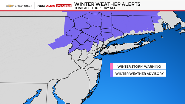
A winter weather advisory is in effect north of New York City. As far as timing the storm out goes, snow will develop north and west Wednesday afternoon and evening, before changing into rain overnight. That will lead to lingering rain and showers Thursday morning.
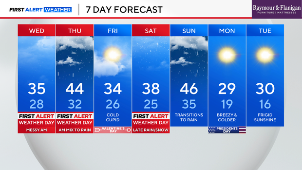
Thursday will bring us warmer temperatures, however. The high is expected to be 44, and it will be breezy and milder.
We're in for a bright and clear Valentine's Day on Friday before getting into Saturday's expected rain and snow mix, which will be mostly in the afternoon. As a result, Saturday will be another First Alert Weather Day.
Live radar around Tri-State Area
Stick with our First Alert Weather team for the latest forecast, live radar and weather alerts.


