Severe weather rolls through southern and central parts of Minnesota


The National Weather Service issued multiple tornado watches and many more severe thunderstorm warnings throughout wide swaths of southern and central Minnesota Monday afternoon.
The NWS says Dodge, Fillmore, Mower, Olmsted, Wabasha and Winona counties were under a tornado watch until just before 9 p.m.
Rice and Goodhue counties were under tornado warnings through 6:15 p.m., according to the NWS. Counties that the NWS currently had under severe thunderstorm warnings included Blue Earth, Faribault, Freeborn, Martin, Steele, and Waseca County until 6:15 p.m.
Check out live radar images here.
Among the cities that are included in the warnings are Owatonna, Albert Lea, Waseca, Blue Earth, Wells, Janesville, Blooming Prairie, Mapleton, Medford, New Richland, Clarks Grove, Ellendale, Minnesota Lake, Elmore, Alden, Glenville, Geneva, Emmons, Bricelyn and Hartland.
Over 4,000 people were reportedly without power for around two hours as storms passed through.
As of late Monday morning, a number of school districts had already announced early closings or the cancellation of afternoon and evening activities.
Here's what we know about Monday's storms and when they are expected to affect your part of Minnesota:

Severe storms in the afternoon
After some early activity, we'll get a temporary break in the late morning and early afternoon before conditions rapidly reload with rising heat, humidity and storm energy.
The St. Cloud area on south — including the Twin Cities — is under a moderate risk for severe weather. As you move to the north and west, the threat diminishes, though much of the state is under some sort of risk.
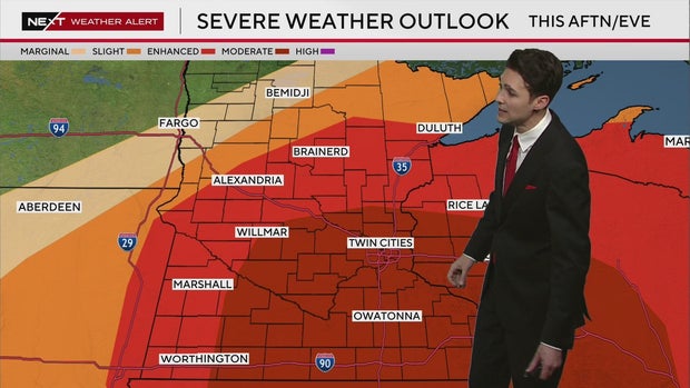
Large cells could start to organize around 4 p.m. before making their way east. Isolated storms could become intense fast, with very large hail, destructive wind gusts and even tornadoes possible.

A tornado watch is in effect until 8 p.m. for these counties: Brown, Chippewa, Cottonwood, Jackson, Kkandiyohi, Lac qui Parle, Lincoln, Lyon, Martin, McLeod, Meeker, Murray, Nicollet, Nobles, Pipestone, Pope, Redwood, Renville, Rock, Sibley, Stearns, Stevens, Swift, Watonwan and Yellow Medicine.
NEXT Weather Meteorologist Joseph Dames says the storms will continue to move on east until around 9 p.m.
A moderate, four-out-of-five risk for tornadoes indicates not only the possibility of a tornado, but one that could stay on the ground for some time, Dames explained.
Things turn cooler and breezy on Tuesday, with no storms expected. Rain returns midweek, though the risk for anything severe is low.
Find more information from the WCCO NEXT Weather Team on severe weather alerts and severe thunderstorms, as well as the dangers of flooding and extreme heat.


