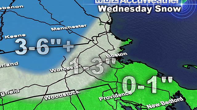
Wednesday Snow Will Be Similar To Sunday Storm
Not only do we have more snow on the way in less than 48 hours, but temperatures following our next snow event are going to be near or below normal for the foreseeable future.
Watch CBS News
Not only do we have more snow on the way in less than 48 hours, but temperatures following our next snow event are going to be near or below normal for the foreseeable future.

Mother Nature decided today that she all of a sudden wants to go easy on us for a change.

What looked like such a slam dunk forecast a few days ago has become an absolute head scratcher. Honestly, this storm could end up being a bust.
We are getting closer and closer to another stormy weekend and while we know it's going to snow, how much is a little more difficult than the last two storms.

This storm will be very different from the last two, mainly because it will be a warmer storm.

This pattern looks as though it will continue for at least one more week as we are eyeing what might be yet another plowable snowfall this weekend.
An area of low pressure is traveling to our west with cold and snow but we are on the warmer side of the storm and a trailing coldfront is sliding through this evening with rain.
What a nice week...and break from the harsh winter conditions over the past few weeks.
These next 24 hours are straight forward and the only problem I foresee is a little black ice later tonight from refreezing.
A well-defined storm system will slide south of us through the Mid-Atlantic tonight leaving us on the northern fringe of the storm where we will only see a bit of snow.
With highs reaching the middle 40s today, our slow and steady snowmelt continued
Today's rain turned snow into slush, big puddles and lots of slop and with the departure of the rain and clearing later tonight temps will fall back into the 30s.

Clearly this is not a storm to be taken lightly. If you have not already completed your storm preparations you should do so immediately.
We are still expecting a widespread 18-to-24 inches or more from this storm, with some isolated areas possibly getting 30 inches.

This could turn out to be a top 5 snowstorm for Boston. There have only been 6 other storms (on record since 1892) when Boston has received 20+ inches of snow from one storm.
The snowstorm Friday will be big, but will it be historic and rival some of the legendary storms of Boston's past? The short answer is it just might.
The last time Boston saw Blizzard Watches was back in 2011...the last time Boston hda an official Blizzard was December 2009...it's been a long time.
While another weak weather system deposits additional dustings to the region tonight for the countless time in the last week, all eyes are focused on the snowstorm potential for Friday into Saturday morning. It's been two years since Boston saw a 10" or more snowstorm and the chances are escalating for that streak to end as we head into the weekend.

There will be no hype here, just the plain old facts as we see them right now, about 72 hours ahead of any sort of storm on Friday.
Heading into another Winter week and the chances for snow are there...they just aren't very big ones.
As we head into another weekend, the cold is a certainty but the snow not so much.
After a wildly warm 24 hours that also featured tropical storm wind gusts and very heavy downpours,
A Spring storm in the middle of the Winter is causing all kinds of problems tonight from Maine to Florida.

We are in for one heck of a ride in the next 24-48 hours, the classic New England-style roller coaster complete with warnings signs and all.
It's been a long time but temperatures are finally emerging