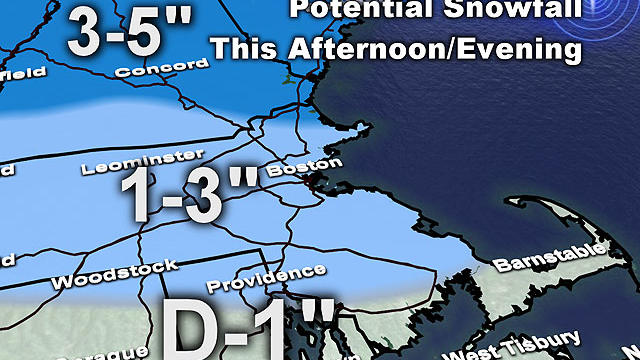
Evening Commute Snow Will Be A 'Nuisance'
A second wave of precipitation will likely keep roads a bit hazardous piling some ice on top of the fresh snow.
Watch CBS News
A second wave of precipitation will likely keep roads a bit hazardous piling some ice on top of the fresh snow.

Temps as of this typing are already in the lower single digits...
Last night's snow was a bit of a dud for most but there were up to 6 inches that fell over SE MA.
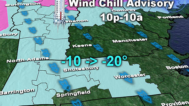
There will be a biting, gusty wind for most of tonight and again tomorrow night, producing wind chill values near 20 below in the northern and western burbs.
We never said this one would be easy and it now appears that the heaviest snowband will set-up offshore...amounts have been lowered.
This will be a harsh winter week with bitterly cold air and two snow events.
At this point, two coastal spots seem most likely to be affected - first, the seacoast of southern New Hampshire down to Cape Ann and second, the South Shore down to Cape Cod
Highs today only reached the 20s despite nearly wall to wall sunshine.
We are on the verge of some of the coldest air of the season...
It was only a few inches but the timing was terrible...the morning commute was a mess.

By rush hour it should be snowing just about everywhere with a rain/snow mix along the immediate coastline.
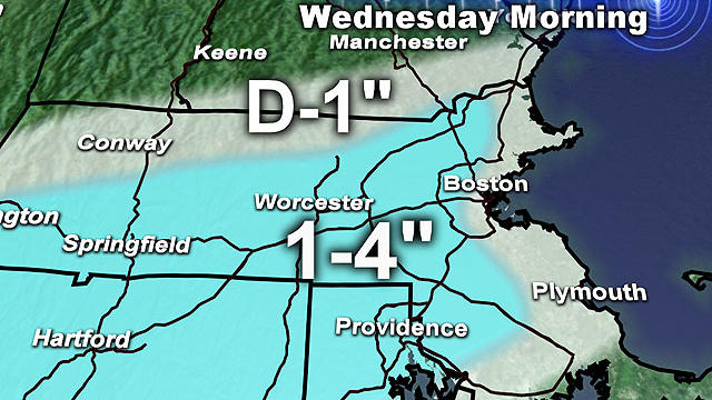
It's been over two weeks since we had any substantial snow and our recent thaw melted it all away but tomorrow we will replenish those depleted and dirty snowpiles with most receiving several inches of snow.
Today was a January gem...and it put the cherry on top of this thaw. Well don't put away the jacket and gloves just yet, Winter is about to come roaring back.
Don't be fooled, this winter is a very LONG way from being over. In fact, I believe the coldest and snowiest days are yet to come.
Rain is moving through tonight with a weak area of low pressure and temps over parts of New England are just cold enough to create icy conditions.
Temps will stay above normal through the weekend and we have a little rain on the way too...
High temperatures were almost identical to yesterday...in the low to mid 40s...but it felt much colder today with the lack of sunshine.
What a nice day...lots of sun and mild temperatures...highs for most climbed into the mid 40s and snowbanks that are in the sun saw some melting.
We are heading into the second week of January, yet it will feel more like a week in March.
After spending about 72 hours below the freezing mark, we finally climbed back above 32 this afternoon.
Congrats to all, you have made it through the harshest part of this cold air outbreak
On a day where the National Weather Service released a statement saying that last year was the warmest on record
We are set up to receive an arctic blast for the first few days fo the new year.

The final storm of 2012 left its mark across southern New England Saturday night into Sunday with about a foot of snow in some towns.
We are well underway here with the second big storm of the week.