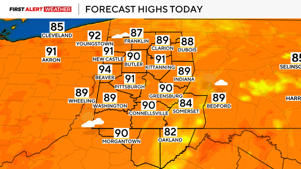
It's going to be hot with isolated storm chances in the Pittsburgh area today

It's going to be hot today in the Pittsburgh area with isolated storm chances.
WEATHER LINKS:
Current Conditions | School Closings & Delays | Submit Your Weather Photos
This morning, temperatures are fairly mild with not and much in the way of moisture in the air. Once the sun rises, this lack of moisture should allow for temperatures to warm up very quickly from the low-mid 60s into the upper 80s to low 90s areawide this afternoon. A few fair-weather cumulus clouds may develop, but no precipitation is expected today. Low humidity in the afternoon should keep heat indices within a degree or two of the actual air temperature. For those attending the pre-season Steelers game, expect temperatures in the upper 80s near game start time and only dropping into the low 80s by late evening. There will not be much wind either.
We are still on track for a couple of weak disturbances to approach our region from the northwest starting Sunday through the middle of next week that will also bring some storm chances. Some isolated/predawn showers may survive the trip into far northwestern PA just before sunrise, but model guidance has slowed the arrival of the actual disturbance driving this activity. It is more likely that we'll start to see more widely scattered showers and storms after 10am lasting through early evening. This is the timeframe the disturbance will be moving across Western PA accompanied with the most amount of available energy and moisture. Slightly higher coverage may occur for areas along and north of HWY 422 toward I-80.
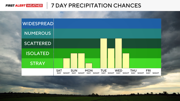
A weak cold front will move through Sunday evening into Sunday night. This will allow temperatures on Monday morning to be a few degrees cooler, but most spots will still rebound fairly quickly into the mid-upper 80s by Monday afternoon as the cold air forcing the boundary south will likely lose most of its punch. Another surge of warm air will move in early Tuesday morning ahead of a second series of disturbances that will bring higher storm chances into the region by next Tuesday into Wednesday.
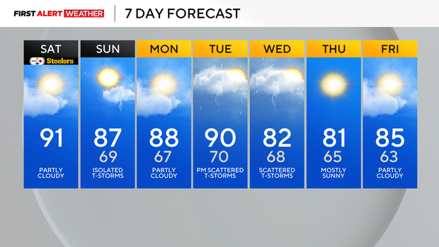
Enhanced cloud cover and a northeasterly breeze will likely hold temperatures down substantially by next Wednesday before temperatures moderate by the end of next week.