Weather: Storms Move Out, Sun Returns
Wednesday morning the atmosphere will dry out, sunshine will gradually return and afternoon high temperatures will be comfortable, in the low 80s.
Watch CBS News
Wednesday morning the atmosphere will dry out, sunshine will gradually return and afternoon high temperatures will be comfortable, in the low 80s.

This bad situation has also underlined clearly the major forces that are trying to jam amnesty down the throats of the average American.

Tuesday will be very similar to Monday, with strong thunderstorms popping up in the afternoon.

A Flash Flood Watch continues through Tuesday evening for most of our area.

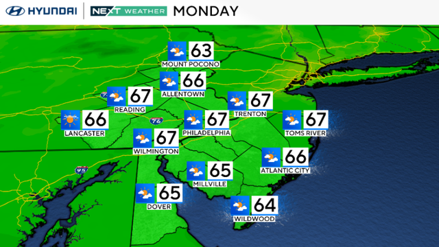
Steamy and stormy will become clearing and cooler by midweek, but we'll have to get through Monday and Tuesday first.

Much like we saw last Thursday in Ocean City, NJ. The high Monday will be 90 degrees.

Canelo Alvarez wants to celebrate his 24th birthday and the fans may want pass on seeing a rematch of the split-decision victory Alvarez captured Saturday night before a sellout crowd of 14,239 at the MGM Grand in Las Vegas.

The sun will have to battle for air time today, but especially Monday and Tuesday as clouds build and move in.

By Monday and Tuesday, we could be dealing with severe storms either day.


It had been eleven days since LeBron James opened for business and he still hadn't signed with any NBA team.

A lot was made about the Polar Vortex this past winter. It gained massive amounts of traction as a hashtag on Twitter and appeared in articles all over the web as a new phenomenon.

With a sluggish cold front finally off-shore, the Delaware Valley can expect mainly dry conditions to end the week and into the weekend.

Additional heavy rain was falling this evening in southern NJ and before the day is over, some parts of region may end up receiving close to 5".

Thursday won't be a bad day ... you'll just have to once again keep an eye to the sky during the afternoon hours.

A cold front will be moving through the Delaware Valley tonight keeping the chance for some showers and storms.
Schlaepfer participated in protests to block buses of immigrants attempting to reach a Border Patrol processing facility in Murrieta, California.

Severe thunderstorms last night brought high winds to the Delaware Valley and led to numerous reports of damage, mostly caused by downed trees and power lines.

Hundreds of thousands of power outages have been reported across the region and crews are scrambling to clean up the mess left by the powerful storms.

Severe thunderstorms will impact the area tonight, delivering a combination threat of severe wind gusts in excess of 60mph, very heavy localized downpours, and frequent cloud-to-ground lightning.

For the second time in two weeks, another heat wave is expected.

A hot and humid air mass continues to build into the region from a stronger southerly wind flow. Tonight will be muggy and warm with low temperatures in the 70s.

Barely a full week into July 2014, and we're already forecasting the second heat wave in Philadelphia so far this month!

Changes in our weather pattern will occur this week, bringing back typical July weather.

It doesn't feel like the July 4th holiday with below average temperatures and a very dry air mass in place.