Philadelphia snow forecast: How much snow, school closings info and latest on snow emergency

PHILADELPHIA (CBS) -- Snow has been falling in the Philadelphia region since Friday morning as a winter storm that could drop up to six inches of snow makes its mark on the area.
Friday morning, the forecast shifted slightly in terms of who will see the top-end of our snow forecast of six inches. It now looks like the heaviest snowfall in this system will set up over South Jersey and Delaware.
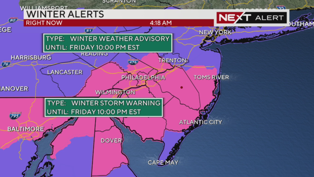
Winter storm warnings were already in effect for much of our region including Camden, Gloucester, Burlington, Philadelphia, Delaware, Chester, Montgomery, Bucks and New Castle counties across Pennsylvania, New Jersey and Delaware.
With the track for the heaviest snow shifting south, winter storm advisories have been upgraded to winter storm warnings in Atlantic County, New Jersey and Kent County, Delaware.
How much snow is Philadelphia getting? Check out our latest forecast with snow totals
The Philadelphia area has up to 5.1 inches in some parts of the area, according to the National Weather forecasts snow tracker update from 3:40 p.m.
Philadelphia International Airport had hundreds of flight delays and more than 40 cancellations and rightfully so. The airport saw 2.9 inches of snowfall, according to the NWS tracker.
There are school closings across the Philadelphia region as a result of this storm and its potential impact on roads during your morning and evening commute.
We're also following the latest on potential delays and cancellations out of Philadelphia International Airport and will have live cameras showing where snow is falling.
How much snow will fall where I live in Pa., NJ and Del.?
Broadly, two to six inches of snow will fall across the region. Snow total estimates are highest in the purple band stretching from Cumberland and Atlantic counties in New Jersey and Kent County, Delaware, up to New Castle, Chester, Philadelphia, Delaware, Camden, Gloucester, Salem and Burlington counties.
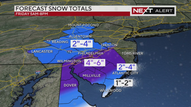
Gloucester County, N.J. saw up to 5.5 inches in Gibbstown as of Friday afternoon. Middletown in New Castle County was right up there with N.J. with 5.0 inches of snowfall. Norristown, Montgomery County had up to 5.2 inches of snow recorded at this time too.
The highest snow totals will be seen where a coastal low will interact with this storm. Our Kate Bilo says any six-inch totals will likely be outliers with this storm and most of us will look at between two and four inches.
The shore points, which could experience some rain and snow mixing, are looking at one to two inches of snow.
This comes on the heels of Tuesday's system that dropped more than three inches in Philadelphia -- and ended the city's nearly two-year-long snow drought.
Timing: When will snow start to fall?
As of 5:45 a.m., we've seen some snowfall in the Poconos and by the 6 a.m. hour, it should start just about everywhere.
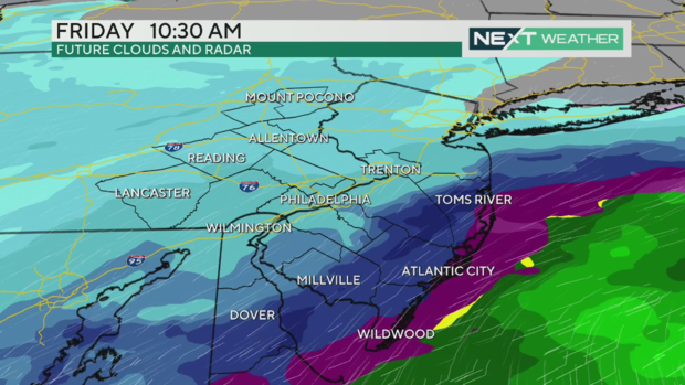
This may start as rain at the Jersey Shore and then the mix line pushes south before a coastal low begins to ramp up offshore, creating the bands you'll see on the map above.
We'll be watching as the band bringing the heaviest snow moves north - will it make it all the way up from the Shore into the northwest suburbs of Philadelphia? It could - we will keep an eye on that for you.
Around 2 p.m. we know we'll see this band of heaviest snow crop up over New Castle County in Delaware and Philadelphia and Delaware County in Pennsylvania.
Snow emergency in Philadelphia: what to know
You might have to move your car if it's parked on a snow emergency route in Philadelphia. Here's the latest on the snow emergency in the city with a link to the snow emergency routes map from the city website.
School closings in Philadelphia area: the latest
We're running school closings along the bottom of the screen if you watch our newscast in the player above or on TV. Or, for the absolute latest from your school district, check out CBS Philadelphia's School Closings page here.
Weekend outlook
More cold air follows Friday's system, so Saturday will be very cold and windy again. Winds could gust to 30 mph and wind chills will struggle to get above single digits.
In Philadelphia, it'll feel like just 2 degrees; in Mount Pocono, it'll feel like -10.
A NEXT Weather Alert remains in effect Saturday, though in this case because of the cold.