Triple-digit heat indices continue for North Texas as shower and storm chances increase


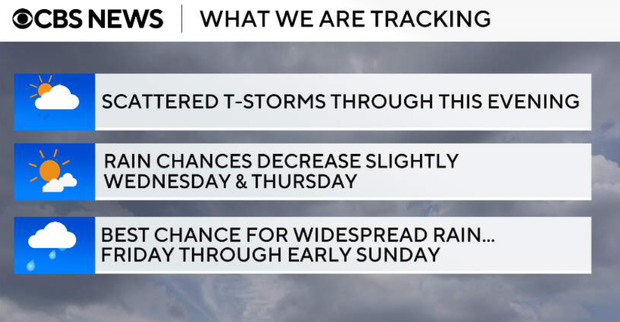
Scattered thunderstorms return Tuesday afternoon and evening as a weak backdoor front moves through North Texas. Better rain chances arrive Friday through the weekend.
North Texas reached the hottest day of the year so far with a high of 96 degrees on Tueasday afternoon.
A weak backdoor front is gradually moving into North Texas from the northeast. The front and several outflow boundaries are interacting with daytime heating and scattered showers and thunderstorms are developing.
A severe thunderstorm warning has been issued for Kaufman, Ellis and Dallas counties until 4: 30 p.m. Wind gusts up to 60 mph and quarter-sized hail are possible.
Storm coverage will generally range from 20% to 40%. Activity will gradually shift from northeast to southwest through the day as the front moves south.
While widespread severe weather is not expected, a few stronger storms could produce gusty winds, frequent lightning, and brief heavy rainfall. An isolated severe wind gust cannot be ruled out, especially south and west of the metroplex where temperatures are in the high 90s.
Storm coverage decreases after sunset as daytime heating fades. A few isolated showers or storms may linger across southwestern portions of North Texas, but most locations become quiet overnight with lows in the upper 60s to middle 70s.
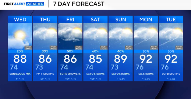
Scattered storms second half of the week
Another day of scattered afternoon thunderstorms is possible, although coverage should be lower than Tuesday. The best storm chances will be across western portions of North Texas. Most locations will remain dry, but any storm that develops could produce gusty winds, lightning, and brief heavy rain.
High temperatures will remain seasonably warm, generally in the upper 80s to lower 90s.
Scattered showers and thunderstorms remain possible Thursday afternoon as weak disturbances continue moving around a weakening ridge. Coverage remains limited, but any storm could produce heavy rain, lightning, and gusty winds. Temperatures stay near seasonal normals (mid to upper 80s).
Friday and Saturday, rain and thunderstorm coverage is expected to increase across all of North Texas. A stronger upper-level disturbance moving out of the Desert Southwest will bring our best opportunity for more widespread rainfall during this period. While the overall severe weather threat remains low, storms will be capable of producing heavy rainfall and frequent lightning.
With abundant Gulf moisture in place, localized flooding could become a concern where storms repeatedly move over the same areas.
Rain and thunderstorm chances increase Friday during the afternoon and evening. Coverage will be higher than what we expect Wednesday and Thursday, with scattered showers and storms developing across North Texas. Heavy rain, lightning, and gusty winds will be the primary concerns. Highs will be in the mid to upper 80s.
Weekend weather outlook
Off-and-on showers and thunderstorms remain possible through much of Saturday. While confidence is high that we'll see rain and storms, the exact timing remains uncertain. Some forecast guidance clears activity during the afternoon, while other solutions keep rain chances around throughout the day.
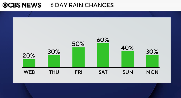
Storm chances continue early next week, although coverage may become more scattered. Temperatures will gradually warm back into the 90s as southerly winds return.