Heat index expected to reach triple digits across North Texas to start June


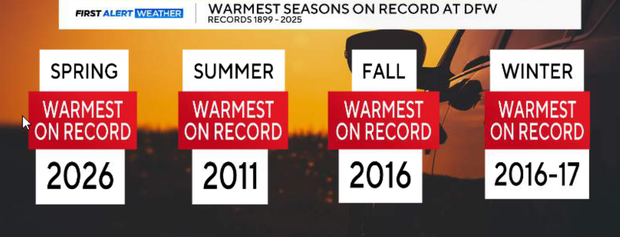
This spring was officially the warmest on record at DFW airport with an average temperature of 70.9. June also begins with hot and humid conditions across North Texas. High pressure remains in control, keeping skies mostly sunny and rain-free.
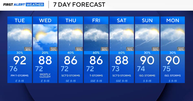
Monday night will be warm and quiet. Mostly clear skies with overnight lows in the low to mid 70s.
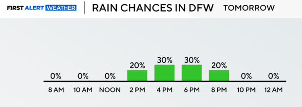
Tuesday, a weak backdoor cold front will slide into North Texas from the northeast during the afternoon and evening. This will bring a 20-30% chance of scattered showers and thunderstorms. This activity will develop initially along and east of I-35 before gradually shifting south and southwest through the evening. A few stronger storms could produce gusty winds, small hail, and brief heavy rainfall, although the overall severe weather threat remains low. Highs reach the lower 90s.
On Wednesday, a subtle pattern change begins as weak upper-level troughing moves out of northern Mexico. Storm chances continue, but coverage may become more focused west of I-35, where moisture and lift will be greatest. Most locations will stay dry, but a few afternoon and evening storms are possible. Highs remain in the upper 80s to lower 90s.
Similar to Wednesday, scattered afternoon and evening thunderstorms remain possible on Thursday, especially across western portions of North Texas. A few storms could produce gusty winds and small hail, but organized severe weather is not expected. Temperatures stay near seasonal averages.
Rain chances increase end of week
Friday and Saturday remain the period we're watching most closely. A stronger disturbance moving into Texas is expected to increase rain and thunderstorm coverage over our area. This currently appears to be the best opportunity for widespread rainfall this week, although exact timing will continue to be refined over the next few days.
Rain chances gradually decrease as the disturbance shifts east of the region on Saturday afternoon and Sunday. A few lingering showers or thunderstorms remain possible Saturday, with lower rain chances by Sunday. Temperatures remain seasonably warm with highs in the upper 80s to lower 90s.