Snow, rain, ice in the forecast for New York, New Jersey and Connecticut this weekend. Here's what to expect.
We're in for an active and stormy weekend, but the First Alert Weather Team has you covered. Both Saturday and Sunday are First Alert Weather Days.
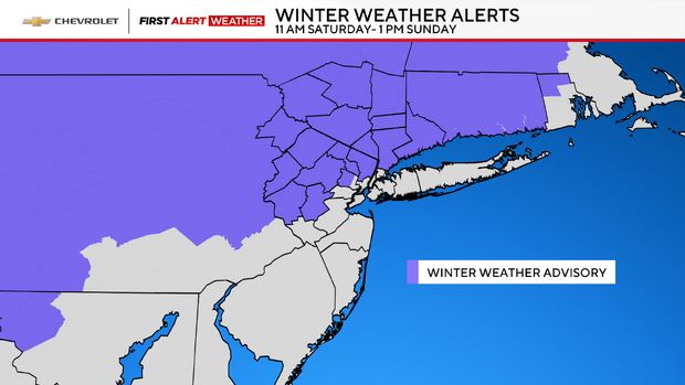
A Winter Weather Advisory will be in effect for the entire Hudson Valley, Connecticut and northern New Jersey from 11 a.m. Saturday until 1 p.m. Sunday.
Saturday forecast
Saturday is a First Alert Weather Day due to snow that eventually changes to a wintry mix and rain.
With cold air firmly in place, snow moves back into the region around noon. The snow could be heavy at times, before a gradual changeover to sleet, freezing rain and plain rain occurs throughout the evening hours.
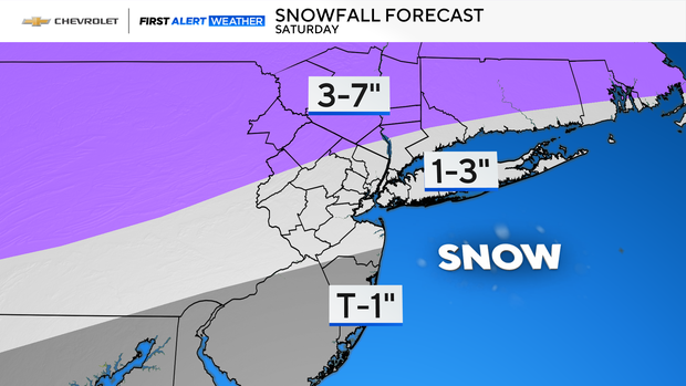
Before the changeover commences, several inches of snow are possible, with the northwestern suburbs seeing a range of 3-7 inches, while the majority of the region sees 1-3 inches. Only a trace to 1 inch is likely for Ocean County.
The rain/snow line should reach New York City by 8 p.m., while areas north and west will hang on to the wintry precipitation.
Sunday forecast
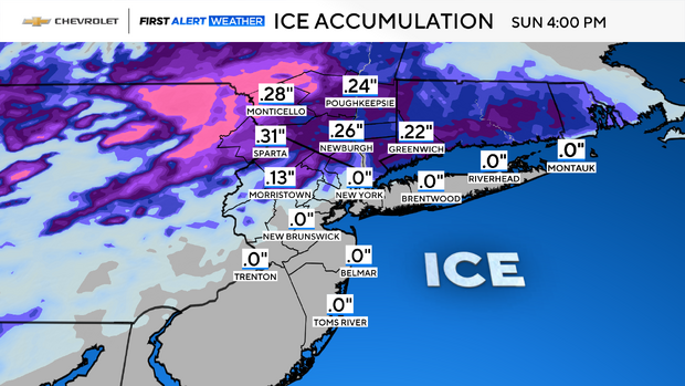
Throughout Saturday night through Sunday morning, freezing rain becomes a major concern for our northwestern suburbs, most notably in Sullivan and Ulster counties, and especially in valley locations where cold air tends to get trapped.
The icing could be significant, as forecast models are still indicating between .25-50" of ice accretion. To see ice accumulations in that range is not common at all in this part of the country. With amounts of ice like that, the threat of downed trees and powerlines is very high. Trees weakened by the ongoing drought would be most susceptible to damage.
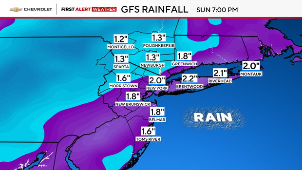
Eventually, all locations will see a changeover to plain rain by Sunday afternoon as warmer air takes over. That rain can be heavy at times, with rainfall totals between 1-2 inches. There may even be a few thunderstorms embedded within the bands of heavy rain.
From the city and points south and east, temps will surge into the 50s to possibly near 60 degrees. A strong cold front will then charge through the region by Sunday evening, putting an end to all precipitation. In its wake, temperatures will plummet again into the 30s and 20s, with strong winds gusting between 30-50 mph.