More snow on the way for NYC area this weekend. Maps show expected snowfall across region
NEW YORK — Another round of snow and sleet is expected to hit the New York City area Saturday night.
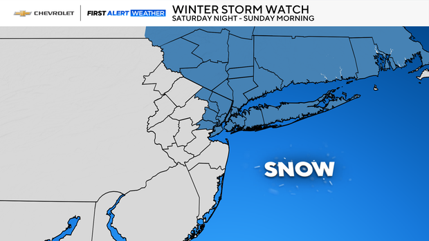
Winter storm watches will be in effect for parts of the Tri-State Area from 7 p.m. Saturday until 10 a.m. Sunday.
We have a First Alert Weather Day for Saturday night's snow and sleet, followed by another Tuesday when there's another high chance of accumulation.
The concerns for this storm will be freezing rain and ice building up on roadways. While it does hit on a weekend, people may be traveling for Super Bowl parties Sunday.
Transportation officials warn drivers to be alert and leave a safe distance from other vehicles, especially salt and plow trucks.
Alternate Side Parking regulations will be suspended in New York City Saturday due to the storm, officials said. Payment at parking meters will still be required.
When will snow arrive in NYC this weekend?
Clouds will be on the move Saturday, but the daylight hours should stay dry.
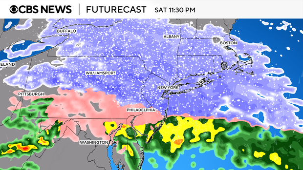
After a quiet daytime, snow arrives from the west-southwest. The storm is arriving at the right time to maximize its potential snowfall.
This storm will travel more zonally than others, with a moderate amount of snow around New Jersey, New York City and Long Island with potentially more significant snow north, where colder air plus elevation will likely bring bigger totals. But much of the area will see snow.
This particular storm does not have as much rain for as many areas. Ocean and Monmouth counties see plain rain after initial sleet and snow. New York City is more likely to hold onto sleet and snow longer than Thursday morning's storm, ending as mostly snow Sunday morning.
How much snow are we getting Saturday?
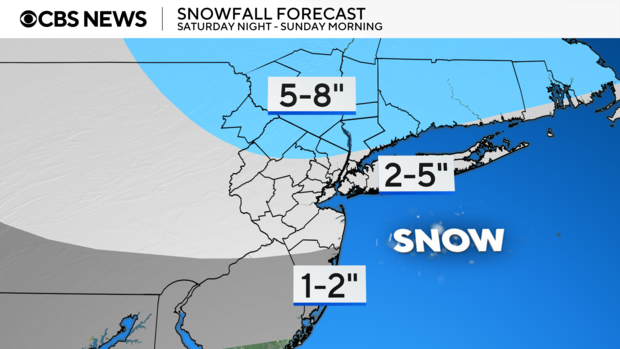
Some of us will be digging out from moderate totals Sunday.
New York City and Long Island could see 2-5 inches of snow.
Areas south of the city are expected to get 1-2 inches, and areas north of New York City could get to 5-8 inches.
Sunday afternoon dries out and temps remain in the 30s. It looks like a good day for some sledding!
Looking ahead
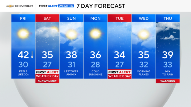
Monday looks good – a breezy but sunny day – before the next system arrives Tuesday.
As of Thursday evening, there is a 40-70% chance of snow and rain in the Tri-State Area on Tuesday afternoon, with a longer period of accumulation possible into early Wednesday.
Live radar around Tri-State Area
Stick with our First Alert Weather team for the latest forecast, live radar and weather alerts.