How much snow fell in New York City and Tri-State Area? See totals throughout the region.
Snow fell in New York City and across the Tri-State Area on Sunday morning and evening, leaving a good amount to measure in its wake.
It was a First Alert Weather Day for New York, New Jersey and Connecticut.
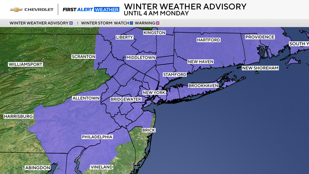
Though the snow has stopped in New York City, Winter Weather Advisories remained in place through 4 a.m. Monday for most Tri-State Area counties, except Ocean in southeastern New Jersey.
An advisory means you're likely to encounter wintry driving conditions.
Snow ends, potential for ice begins
The second of two rounds of snow moved into the area at around 6 p.m. and added an additional inch to the Sunday morning total before winding down at around 9 p.m. The big concern going forward shifted to the potential for black ice, as temperatures were expected to plunge into the 20s, ensuring that any untreated roadways and sidewalks will freeze over, becoming very slippery.
The cold blast is expected to last for several days.
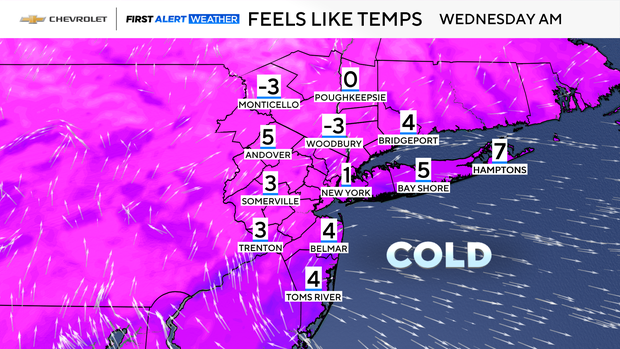
Dr. Martin Luther King Jr. Day on Monday will be blustery, with highs struggling to get above the freezing mark. Even colder air lies in store for Tuesday, as an air mass that has origins in the Arctic settles into the region. Highs that day will only reach the low to mid 20s.
Lows on Wednesday morning are anticipated to be the coldest of the season so far, with the predictions of 14 degrees in Central Park not only the coldest this winter, but one of the coldest mornings of the last several winters. While the actual temperatures will be very cold, the wind chills on Wednesday morning will be downright bitter, feeling like single-digit and sub-zero readings.
Some moderation in temperatures will occur late week before another bitter blast arrives by the weekend.
Sunday snow totals across the Tri-State Area
The bulk of the Tri-State Area was expected to receive 2-4 inches, with 1-3 predicted for the northwestern suburbs and along the Jersey Shore. On eastern Long Island, a total of up to 5 inches was thought possible.
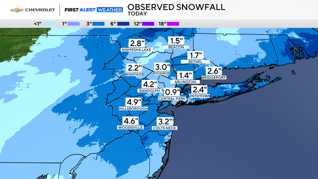
Those predictions ended up being fairly accurate as some notable snow totals across the region were:
New York:
- Roslyn Heights 3.7"
- Syosset 3.6"
- Donegan Hills, Staten Island 3.3"
- Staatsburg 3.3"
- Monroe 3"
- Highland Mills 2.9"
- Kiamesha Lake 2.8"
- Flatbush, Brooklyn 2.5"
- Smithtown 2.4"
- Jamesport 1.1"
- Central Park 0.9"
- Upton 0.7"
New Jersey:
- Hillsborough 4.9"
- Woodsville 4.6"
- Randolph 4.2"
- Metuchen 3.9"
- Colts Neck 3.2"
- Montville 2.5"
- Leonardo 1.7"
Connecticut:
- New Canaan 3.5"
- New Preston 3.3"
- Shelton 3"
- Weston 2.7"
- Bridgeport 2.6"
- Newtown 1.7"
- Bethel 1.5"
- New Fairfield 1.2"