Colder weather returns to NYC area with sub-freezing temperatures in suburbs. Get the First Alert Forecast.
Colder weather returns to the New York City area this week with sub-freezing temperatures in the suburbs.
In the wake of the cold front that delivered Sunday's rain, a chilly, March-like weather pattern will settle in through Tuesday.
As for Monday, expect a blend of sun and clouds with a few spotty showers. Some snowflakes may mix in as well, far north and west of the city. Little to no accumulation is expected, though. Highs will only reach the low to mid-50s, but a stiff breeze, with gusts up to 25 mph, will make it feel no higher than the 40s all day.
A reinforcing shot of cold air moves in by Monday night, setting the stage for a wintry feeling Tuesday morning.
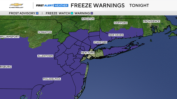
With temperatures forecasted to bottom out in the 20s and low 30s across the suburbs, a hard freeze is imminent. After last week's record-breaking warmth, all of the local vegetation is in full bloom. The coming freezing temperatures could cause some serious damage to certain crops, such as peaches and apples.
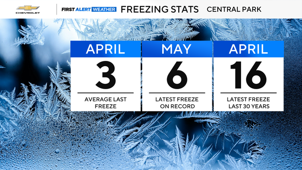
Although the city may come close to the freezing mark, freezing temperatures are not expected. However, if the city does reach the freezing mark on Tuesday morning, it will be the latest freeze in the last 30 years.
Temperatures will return to average levels by Wednesday and then climb above average to end the week. Not much rainfall is anticipated throughout the week, with only a few minor chances.


