Tracking Ian: Storm's remnants bring rain to Tri-State Area
NEW YORK -- Now a post-tropical cyclone, Ian was expected to dissipate by Sunday morning, according to the National Hurricane Center.
See live updates below for the latest track and timing.
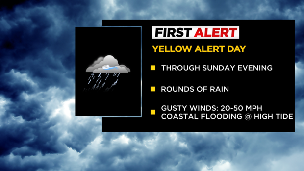
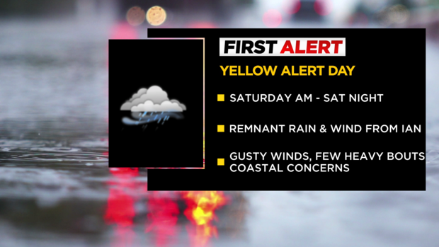
Yellow Alert issued for Sunday as remnants of Ian bring rounds of rain
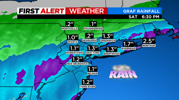
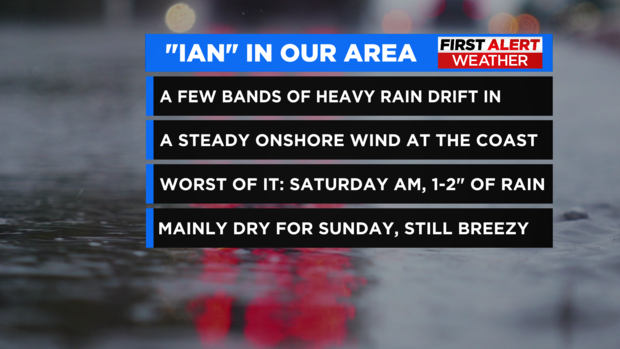
After a very wet start to the day Saturday, we are now seeing a break in the rain. The rain has been in association with the remnants of Hurricane Ian. It is also very damp, cool and breezy. Temps have been hovering in the mid to upper 50s and will stay there for pretty much the next 24 hours.
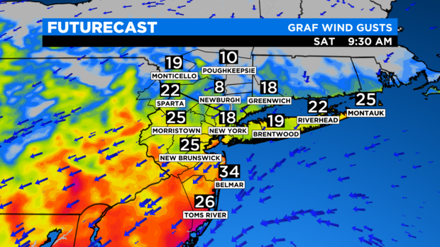
For Saturday night and early Sunday morning, it will be mostly cloudy with waves of showers at times. Damp and breezy conditions will prevail. Wind gusts will average between 10-20 mph, with higher gusts along the coast. Our low will be 56.
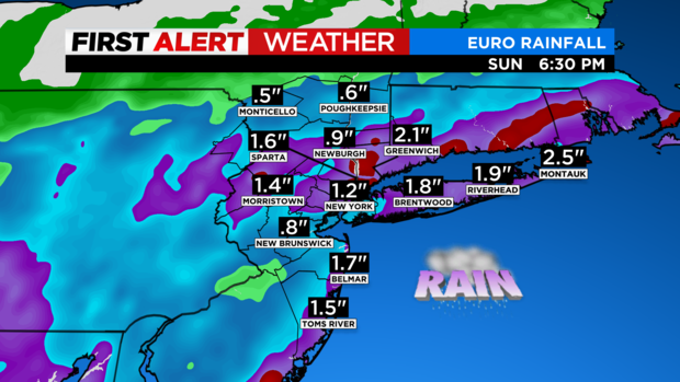
Sunday looks to be nearly identical to Saturday, with some minor differences. Unlike Saturday, rain will be lighter overall and will persist from the late morning through the afternoon. Areas to the south and east of the city is where the rain will be most concentrated.
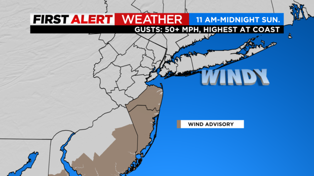
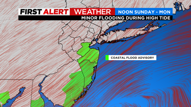
Winds will also be higher than Saturday, with some gusts reaching 40 mph, especially for coastal New Jersey. The winds may lead to some coastal flooding, and therefore a coastal flood advisory and a wind advisory have been issued in these areas. We will struggle to reach the 60-degree mark, with a high of only 59.
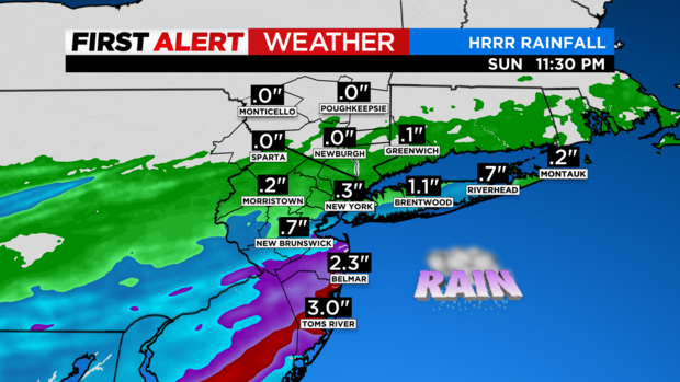
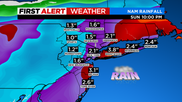
Regarding rainfall totals for the period, forecast models have come down considerably from where they were Friday. Now it appears that the majority of the region will see additional rain totals averaging around a quarter of an inch, while coastal New Jersey may see totals well over an inch. A Yellow Alert is in place through Sunday.
Winds picking up in Tri-State
Yellow Alert issued as Ian remnants move into our area
The rain from Ian's leftovers inched north Friday night. Light bands of rain made their way through Monmouth and Middlesex counties in New Jersey.
Our CBS2 First Alert Weather team has issued a Yellow Alert for Saturday and Sunday.
SATURDAY
Midnight-3 a.m.: Rain bands arrive
3-8 a.m.: Heavy bouts of rain push north through New York City, northern New Jersey and parts of the lower Hudson Valley over to Fairfield County, Conn.
8 a.m.-noon: Heavier rain pivots east across Long Island with showers and a raw feel for much of the area
Noon-10 p.m.: Generally drier with a busy breeze from the northeast
SUNDAY
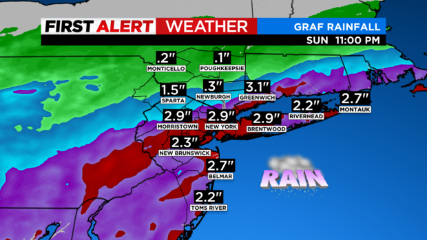
Sunday is now trending wetter and windier at the coast. This weather will disrupt your day. As the cold front tries to kick Ian's leftovers out to sea, they will phase a little, and we could now see another round of rain. There will be a decent range in rainfall numbers and effects. North of Rockland County will see little rain and wind compared to, say, Beach Haven, New Jersey, or the eastern half of Suffolk County. Winds could increase by Sunday afternoon with gusts to 45 mph out east.
Midnight-6 a.m.: Damp, showery, breezy
6 a.m.-noon: As the front tries to kick back, showers blossom over much of the area and winds increase a bit.
Noon-6 p.m.: Moderate bouts of rain and steady showers for many. Winds really kick in during the afternoon along the coast.
6 p.m.-midnight: Showers, stronger line of rain pushes south and east. Still damp and breezy.
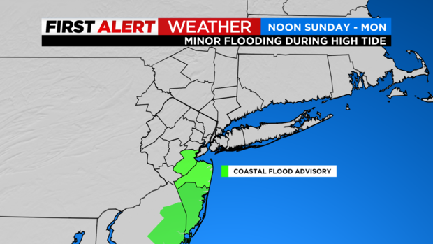
The National Weather Service has issued a Coastal Flood Advisory for the Jersey Shore.
Monday will be wet to start with a drier afternoon. Tuesday is also looking a little better with chances for rain in the morning but a drier afternoon, as well.
Tracking Ian: Friday 5 p.m. update
Ian approaching our area
Moisture from Hurricane Ian will bring rain and wind to our area overnight Friday into Saturday.
The CBS2 Weather Team has issued a Yellow Alert in advance of the storm.
The rain is expected to start after midnight, with the worst of it early Saturday morning. It should wrap up by early afternoon.
New York City will likely see one to two inches of rainfall when it's all said and done.
We're also expecting cool temperatures and blustery winds.
Ian has sights set on South Carolina on Friday
Ian regains hurricane strength
Ian impacting travel in and around Florida
Tropical Storm Ian heads off shore
Ian was downgraded to a tropical storm overnight, with sustained winds of 65 miles per hour.
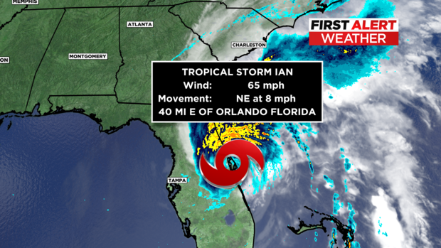
As CBS2's Elise Finch reports, there are still concerns that heavy rain and storm surge will cause catastrophic flooding, plus strong winds causing power outages.
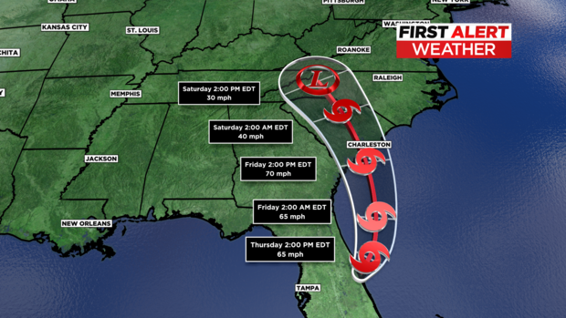
The storm is moving off shore over the Atlantic today, and it's expected to make landfall Friday in South Carolina. It will likely be a very strong tropical storm, nearly at Category 1 status.
The remnants of the system could bring leftover rain to our area Saturday morning.
Stick with the CBS2 Weather Team for the forecast.
Coast Guard on rescues underway
Historic direct hit
Wednesday 11 p.m. update
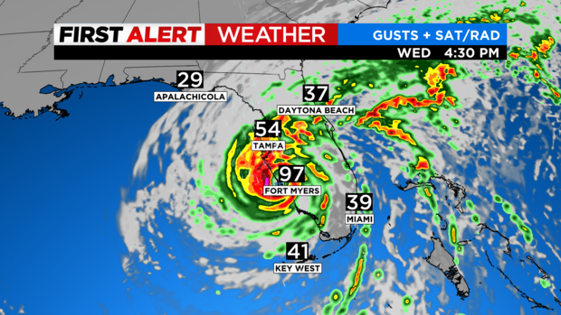
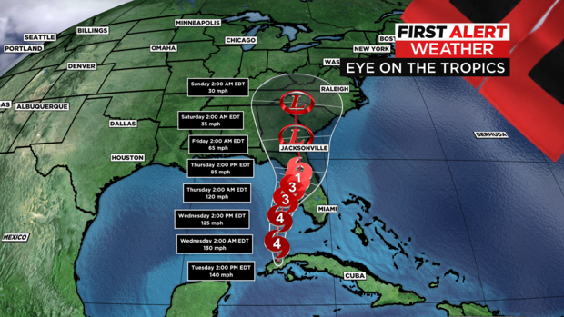
As of 11 p.m. Wednesday, Hurricane Ian is a category 1 storm located 80 miles south of Cape Canaveral, Florida, with winds sustained at 90 mph.
Gusts in Tampa were near 65 mph around 8 p.m.
The worst of the wind is over, but heavy rainfall is still a problem as well as inland flooding.
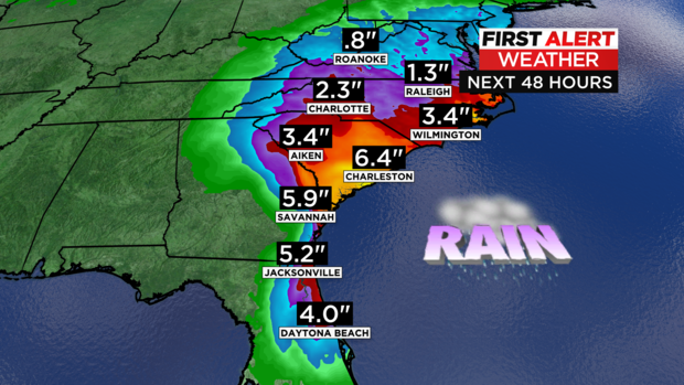
The storm is such a slow mover that there is still potentially 12-16+ hours of rain before the storm pops offshore of South Carolina and likely makes another landfall near Charleston, South Carolina, on Friday.
What's next?
Heavy rain bands will hit the Carolinas and Virginias before we feel at least some of the remnants.
If the storm pops offshore and stays offshore, it has a relentless moisture feed -- the ocean -- and that could be troublesome.
On the other side of the coin, if the storm pulls back west and drifts farther inland, we could see just some light showers.
We will have a better grip on what our weekend forecast holds shortly, but let's start by planning on some rain for Saturday.
We will likely see another round of tropical remnants Monday into Tuesday.
Wednesday 8 p.m. update
Communication woes become worse as Hurricane Ian makes landfall
Communicating during hurricanes can get tricky as phone and internet signals fail. It is that not knowing that has become torture for some Tri-State Area families with loved ones in Florida.
CBS 2's Dave Carlin has more on how they are holding up as Hurricane Ian lashes the Sunshine State.
READ MORE: CBS2 speaks with loved ones here and families in Florida impacted by Hurricane Ian
Ian makes landfall as Category 4 storm
Hurricane Ian made landfall near Cayo Costa, Florida, on Wednesday as a major Category 4 storm — the second-strongest possible category on the Saffir-Simpson Hurricane Wind Scale, according to the National Hurricane Center.
Mid-afternoon update
Landfall fast approaching
9 a.m. Wednesday update
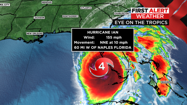
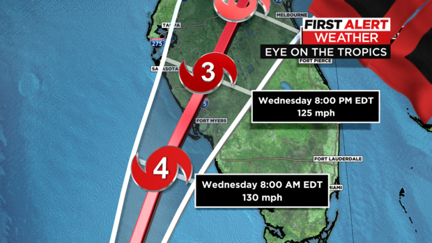
Hurricane Ian has strengthened to a Category 4 storm, with 155 mile per hour winds.
It's expected to maintain strength or weaken slightly before making landfall early Wednesday afternoon.
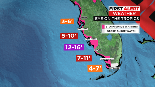
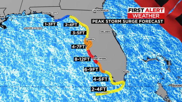
The strongest storm surge is forecast near Fort Myers at 12 to 16+ feet.
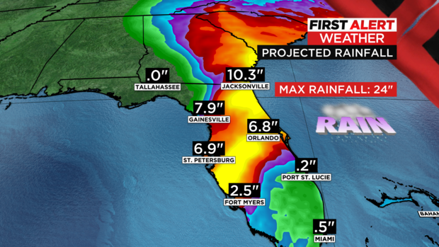
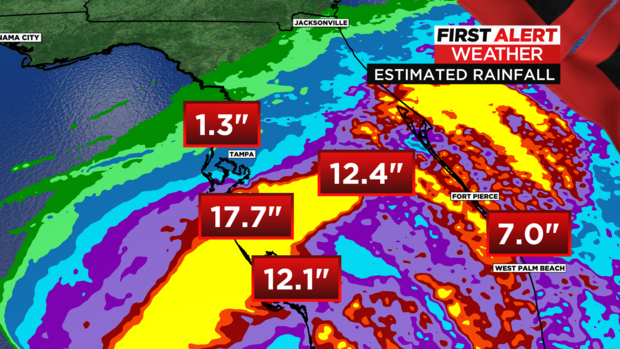
Central and northeast Florida are projected to receive 8 to 14 inches of rainfall, with some areas seeing 18 to 24 inches locally.
Florida bracing for landfall
Ian strengthens to Category 4 storm
CLICK HERE for the latest from the National Hurricane Center.
11 p.m. Tuesday update
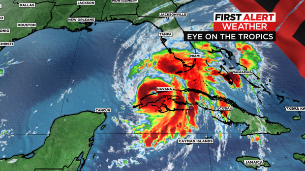
As of 11 p.m. Tuesday, Hurricane Ian is lashing much of southern Florida, with a Tornado Watch in effect until Wednesday morning. Multiple reports, as well as radar, indicated funnel clouds have been seen.
Winds are currently 120 mph, holding Ian steady as a Category 3. It's moving at 10 mph north. It's a healthy storm with large eye about 33 miles in diameter. In addition to tornado watches, flood alerts have been popping up all day. The models are indicating possibly becoming a Category 4 before landfall, due to the slow progression.
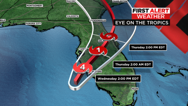
It will now likely make landfall in Fort Meyers between Sarasota to Naples on Wednesday afternoon.
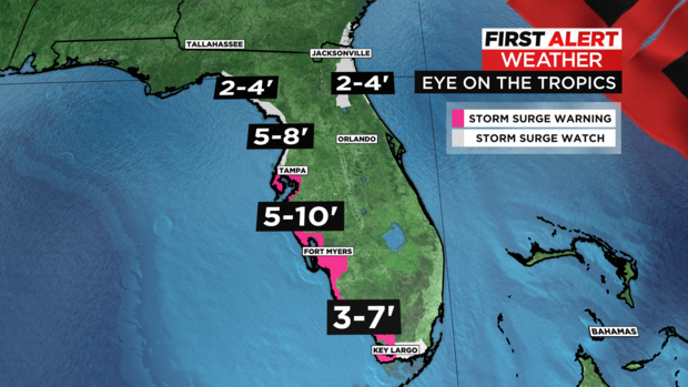
Regarding storm surge, numbers are up a little from yesterday, now showing 8-12 feet at its peak from just south of Tampa Bay, down to Bonita Beach.
Potentially huge rainfall numbers could be seen through northern central Florida, with 1-2 feet of rain on the table for some areas.
Hurricane force winds over 74 mph are likely to start hitting land Wednesday morning and could last through much of the day. The storm is slowing down a bit, allowing for multiple high tide cycles to occur. This is what will prolong any surge or inundation and really elevate the dangers. As the eyewall breaches the beaches Wednesday afternoon, peak winds will occur.
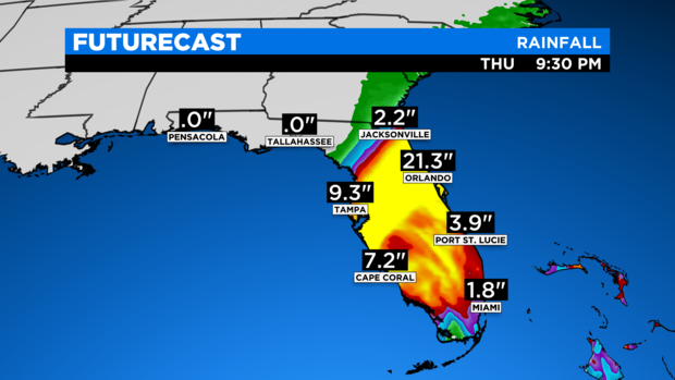
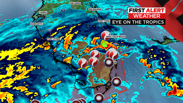
Tornadoes have spawned south of West Palm, with lines of thunderstorms through much of Tuesday. The heavy rain will pivot north, currently eyeing Orlando right now as a rainfall bullseye. Miami will see fringe effects of the storm with 1-3 inches of additional rain and gusts to 40 mph.
All of this subject to shift some regarding track and possibly intensity, but nothing is stopping this monster from ruinous effects in Florida.
Florida residents fly into Tri-State airports
New model runs as of 5 p.m. Tuesday
The First Alert Weather team has released the latest model run of Hurricane Ian's track.
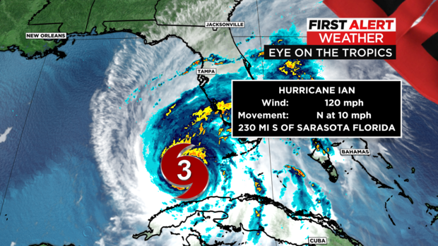
Right now, the Category 3 storm is moving north at 10 miles an hour. The storm is located about 230 miles south of Sarasota, Florida.
It's packing winds of 120 miles per hour.
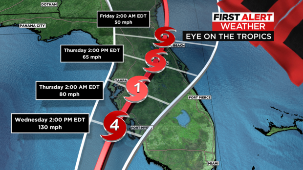
The latest forecast models show the storm hitting near Fort Myers as a powerful Category 4 storm late Wednesday. It will slow as it moves across the state, diminishing in power but soaking the area.
Thursday morning, it is expected to be a Category 1 storm near Tampa, diminishing in strength but continuing to dump rain across the state Thursday and Friday.
Elise Finch's noon forecast
Tuesday a.m. track and timing
Hurricane Ian was upgraded to a Category 3 storm overnight, before making landfall early Tuesday morning in Cuba.
The storm is expected to track northeast through the Gulf and strengthen to a Category 4 storm later in the day.
It will likely weaken slightly before hitting Florida's west coast late Wednesday into Thursday.
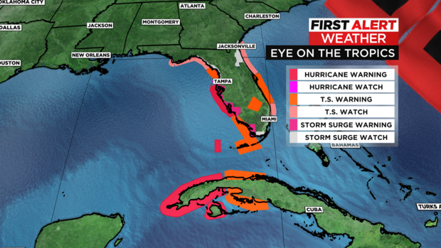
Most of the state is under some kind of hurricane watch or warning, and evacuations are underway.
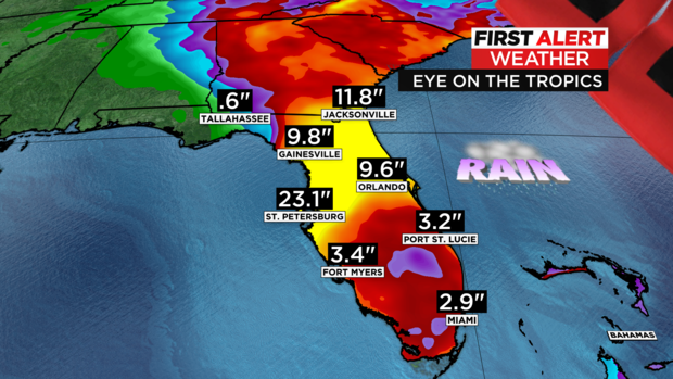
Some areas could see nearly two feet of rain before the system moves out.
Flash flooding, damaging winds and storm surge are all a concern.
Florida businesses and residents bracing for impact
Storm surge alert system explained
Category 3 storm makes landfall in Cuba
The major hurricane made landfall early Tuesday morning in Cuba with sustained winds around 125 miles per hour.
CLICK HERE for more from CBS News.