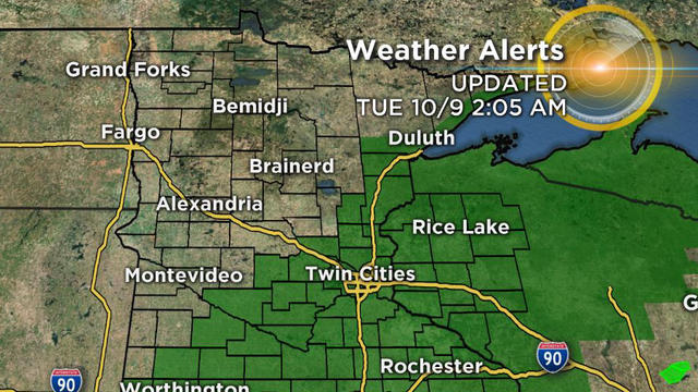
Flood Threat Shifts East, Still Tracking Toward Southeastern Minnesota
While the forecast for Minnesota remains soggy Tuesday, the flood threat has shifted east.
Watch CBS News
While the forecast for Minnesota remains soggy Tuesday, the flood threat has shifted east.

Minnesota could see above-normal temperatures and below-normal levels of snowfall this winter, according to the Old Farmer's Almanac.

If you're going to fireworks displays Wednesday night, you should stay dry in the immediate Twin Cities metro.

After finishing up our biggest April snowstorm in 34 years, record low temperatures have been recorded overnight in parts of Minnesota and Wisconsin. Meanwhile, Friday is looking to be the coldest April 6 in 145 years of weather records.

The first round of snow is mostly over, but another, heavier wave will hit the Twin Cities overnight.

The National Weather Service issued a winter storm warning for an area stretching from Fargo through Bemidji, Brainerd, Duluth and Hayward, Wisconsin.

After a morning of rain, sleet and thundersnow, Minnesotans are bracing for the brunt of a winter storm that threatens to dump more than six inches of snow on communities across the state.

Following rain – and even thunderstorms – Sunday morning, a storm system is tracking toward Minnesota and could leave some parts of the state with more than six inches of heavy, wet snow by Tuesday.

The Minnesota State Patrol says dangerous travel conditions caused by freezing rain and snow contributed to hundreds of crashes and spinouts across the state, including two fatal accidents.

After our coldest Halloween in 15 years, several inches of snow fell in central Minnesota and the Twin Cities Metro.

Minnesotans are bracing for the season's first snow, which will fall during Friday morning's commute in the Twin Cities and leave some communities up north with up to eight inches of snow.

We hope you took the chance to get outside and enjoy the sun on Sunday, because changes are coming in the forecast this week.

After a round of showers and storms pass through Minnesota Tuesday morning, more severe weather is expected later in the evening.

A day after western Wisconsin experienced heavy apparent tornado damage that killed one person, more severe storms are expected Wednesday afternoon.

A winter storm is expected to move into the state later Tuesday – mostly after the evening commute.

Saturday will be a Top 10 Weather Day, with a forecasted high of 54 degrees. This would match the record high set in 1896.

After two of the hottest days of the year in the Twin Cities this past weekend, it's going to feel a whole lot like fall over the next two days. The culprit: heavy rain that will start to move into the metro by late Tuesday morning.

Monday was the comfortable one with low humidity and temperatures peaking below average in the 70s. Tuesday will be the average one with highs climbing into the low 80s with a southeast wind blowing 10-15 mph.
We are locked in cool, northwest flow. These temps are average for around April 20 -- not late-May.
We have an upper-level area of low pressure positioned over the Dakotas to thank for this dreary and cool start to the weekend!
It had been nine days since we last felt the 70s. Tuesday's high of 73 cracked that streak and brought many smiles around town.
It will be a little cooler than average this weekend, and try to remember what April showers bring.
We are still suffering from drought conditions across the state and into western Wisconsin. So, any rainfall at this point is welcome rainfall.

It was all about the strong wind , and we finally received some much needed rain Friday.

It could be worse. It could be a snowy Easter. Or a bitter cold one. Instead the greatest weather factor will be the wind.