Several rounds of storms expected in Minnesota throughout weekend


A Next Weather Alert is in effect until Saturday at 4 a.m. as storms roll across Minnesota.
East Hennepin County and southern Ramsey County were under a flash flood warning until 6:15 p.m., according to the National Weather Service.
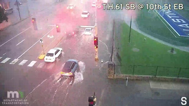
A severe thunderstorm issued early Friday evening for much of central Minnesota, which was supposed to be in effect until 11 p.m., has since been canceled for most of the region, except Wabasha County.
A front with a swampy air mass is expected to be around the state until Monday, resulting in repeated rounds of storms, mainly during nighttime and early morning hours.
There's a slight risk for a tornado, heavy rain, flash floods, hail and wind with these storms.
The heat and humidity on Friday morning made for uncomfortably soupy conditions in Minnesota. Highs were expected to be in the upper 80s in the Twin Cities, with feels-like temperatures hitting the mid-90s.
Daytime hours on Saturday and Sunday may feature a few stray showers or storms, though they'll be mostly dry with dew points in the low 70s.

The last wave of rain and thunder will move through on Monday.
Tuesday through Friday of next week will be mainly dry with dew points in the mid-60s and temperatures in the low 80s.
Signs are pointing toward a big cooldown next weekend and for the second week of the Minnesota State Fair.