Bitterly cold conditions to persist in the Twin Cities for next several days

MINNEAPOLIS — Monday marked the seventh consecutive day of below-average weather in the Twin Cities, and the trend will continue for around 11 more days.
The coldest air around the entire northern hemisphere — shown on the map in white and gray — is settling into Canada and over Greenland. The two areas of cold will be nearby or overhead through most of next week.
Monday night will be one of the coldest of this stretch with temperatures between minus 10 and minus 20 degrees. Cold weather advisories are in effect in areas west and north of the Twin Cities, with a small chance parts of the metro will be included by Tuesday morning.
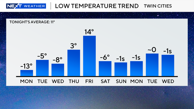
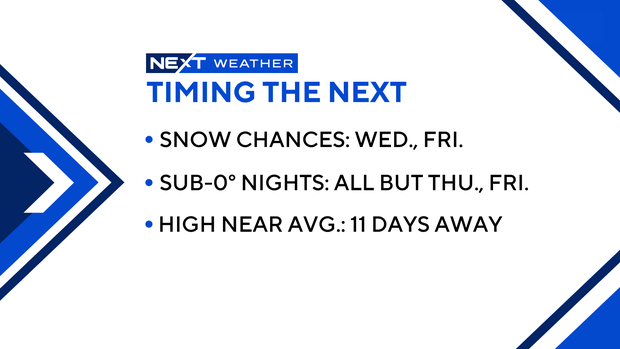
Low temperatures over the next week and a half are expected to mostly at-or-below zero, except for Thursday night and Friday night, February 14. On Valentine's Day, the highs are expected to be in the mid-to-upper 20s.
Possible snow in the mix
The next chance for minor snow flurries is Wednesday, Feb. 12. A system to the south may clip areas as far north as the Twin Cities with a dusting, and an inch or two in far southern Minnesota.
A snow-producing system on Valentine's Day shows promise for a more widespread light snowfall. Early estimates show a chance for 1 to 2 inches of accumulation, but this system is still several days away and that forecast could still change.