A strong winter storm will impact the mountains of Colorado, blizzard south and east of Denver

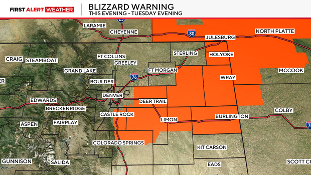
Blizzard warnings have been issued south and east of Denver. Treacherous travel due to wind and snow is expected overnight Monday into Tuesday afternoon for portions of Colorado's Eastern Plains.
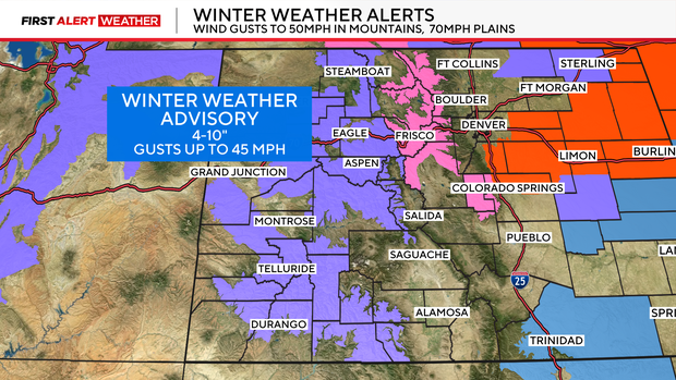
Let me start with the high country as widespread 4-10 inches of snow is expected throughout the day on Monday. This activity will begin to spill across the foothills and Eastern Plains in the afternoon.
Temperatures will be far too warm for snow for the first few hours, but this is where things get interesting. This is our first warm storm of the year, meaning temperatures are marginal, this means the snow will be wet and heavy -- the back-breaking stuff. It also means a more favorable storm track will be needed for most of us to even transition to snow. Think of it like this: when large amounts of water fall, it will absorb heat from the environment as it evaporates. This process cools the surface. A weaker storm will result in lighter precipitation and milder temperatures.
For the Denver, this storm will largely be a miss. A slushy inch or two of snow is possible downtown and roads will stay wet. The far southern parts of the Denver metro area will be more likely to get an inch or two of accumulation.

Blizzard warnings have been issued south and east of Denver to include a portion of I-25 and I-70 on the Plains. They will all be in effect at least through Tuesday afternoon.
High winds will develop Monday night
Another aspect of the storm will be the strong winds. High Wind Warnings have been issued through 5 PM on Tuesday for gusts up to 65 mph. The combination of snow and wind will lead to downright treacherous travel at times across I-70 and the Palmer Divide (the gap between Colorado Springs to Denver). Snow may not be actively falling during the morning commute, but blowing snow will still be capable of reducing visibility to less than ¼ mile.
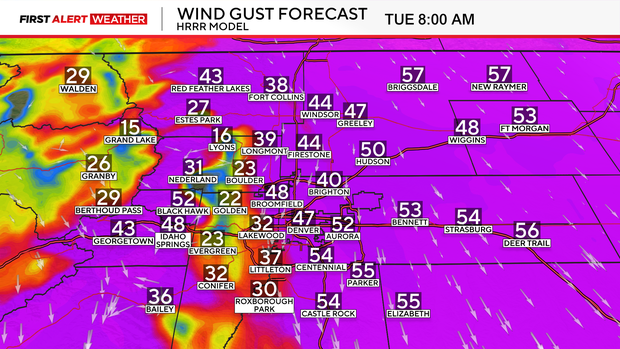
Winds of this magnitude make it difficult for high-profile vehicles to drive on a sunny day, so it won't take much snow or wet roads to create tricky travel conditions. I'd plan on major delays and possible closures for the early morning commute (before 8 AM).
Wind direction will also play a big role with this storm:
Please continue to check the First Alert Forecast as this system continues to evolve.


