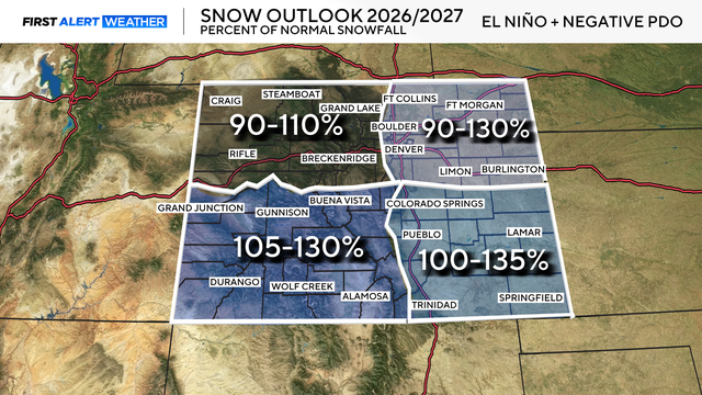
El Niño odds rise, but Colorado winter snow chances still depend on storm track
El Niño does not guarantee that it will happen. It just opens the door.
Watch CBS News
First Alert Meteorologist Joe Ruch's passion for meteorology developed at just 12 years old. He was at the Eagles vs. Lions Snow Bowl game, the forecast called for 1-3" of snow in Philadelphia, but the storm dumped 9" of snow with blizzard conditions. This sparked his curiosity as to why the forecast went wrong and the rest is history.
After pursuing a Bachelor of Science Degree in Meteorology and Atmospheric Science from Penn State University, he took a leap of faith and moved to Colorado Springs. It was not long before he found himself chasing all types of weather from snow to tornadoes. Joe quickly fell in love with the challenge of forecasting the weather along the Front Range. Mother Nature always has a trick up her sleeve.
In 2024, Joe was hired by CBS News Colorado and began forecasting from the First Alert Weather Center. Within a few days of joining the team, an epic snowstorm dumped more than a foot of snow on parts of the Denver metro area and Joe was able to provide important updates on the snowfall totals to CBS Colorado viewers.
Aside from forecasting the weather, Joe loves to spend time outside. He has enjoyed exploring the high country, whether that be going on hikes or camping overnight. Joe's favorite trip so far was hiking to the top of the sand dunes in the Great Sand Dunes National Park & Preserve on a hot summer day (never again).
You'll also find Joe exploring new restaurants downtown. He loves food!
Just The Facts
• Position: First Alert Meteorologist
• Year hired: 2024
• Alma Mater: Penn State
• Hometown: Garnet Valley, PA
• Hobbies: Fishing, Eating, Working Out
• Favorite Food: Salmon
• Number of Siblings: 3
• Least Favorite Chore: Folding Laundry
• Least Favorite Noise: The screech from chalk on a chalkboard
• What keeps you in Colorado? How unpredictable Mother Nature can be

El Niño does not guarantee that it will happen. It just opens the door.
Denver is heading into its wettest stretch of the year, but the city is not just looking for normal moisture from here on out. It needs extra moisture to make up for what was missed during the winter and early spring.
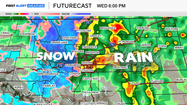
A spring storm is bringing a soggy and cool start to the week across Colorado, with rain for the lower elevations and accumulating snow in the mountains and upper foothills.
A spring storm will bring a sharp split in Colorado's weather on Monday, with rain expected in Denver and along the lower I-25 corridor while accumulating snow falls in the mountains and upper foothills.
Wednesday could also tie the daily record high for May 13. The current record is 90 degrees, set in 1915.
A stronger and wetter storm will move into Colorado Monday night through Wednesday, bringing widespread precipitation and an increasing chance for accumulating snow along the Front Range and I-25 corridor.
That designation means fire weather conditions are about as extreme as they can get in the outlined areas.
The bigger concern is what comes with the warmth: low humidity and gusty winds developing late Monday morning. That combination can turn a small spark into a fast-moving fire.
Some people who live in the Denver metro area on Thursday afternoon were making calls to 911 after skies became noticeably hazy.
That means Denver has now broken its all-time March heat record twice in less than a week.
Denver broke a 130-year-old heat record for March 24. The previous record was 76 degrees, set in 1896.
Denver could see four consecutive days of record-breaking warmth from Thursday through Sunday.
New climate data show the December through February period ranked as the second warmest winter in the United States in NOAA's 131-year climate record. Several western states, including Colorado, Arizona, Nevada, New Mexico, Oklahoma, Oregon, Texas, Utah and Wyoming, recorded their warmest winter on record.
The heaviest snow bands are expected through about 1 p.m. across the Front Range, meaning roads may toggle between wet and snow-covered several times through the afternoon.
Three to four feet of snow is possible in the hardest-hit areas, including Wolf Creek Pass and the San Juan Mountains. For most of the northern and central mountains, widespread totals of 10 to 20 inches are expected.