High wind warning in Massachusetts remains, but snow chances on Thursday fading
After the last few mild and relatively snowless winters, perhaps many of you were wondering if Boston was losing its winter mojo.
Well, we're back.
High wind warning Massachusetts
Most of Massachusetts is under a high wind warning until 5 p.m. on Tuesday.
We will have frequent gusts between 40 and 50 miles per hour and a few as high as 55 mph in the higher elevations in central and western Massachusetts.
Several trees and limbs will fall and that means there's a threat of power outages.
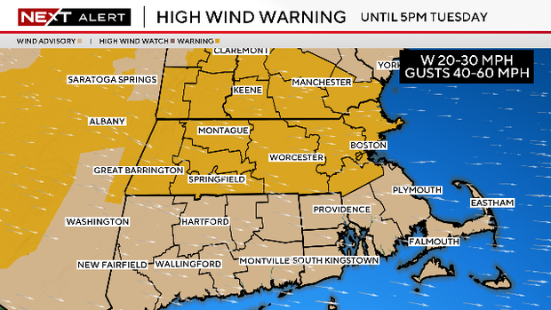
The peak gusts will slowly decrease below warning thresholds early Tuesday but still remain very busy.
Tuesday won't be as windy as Monday, but we expect frequent gusts over 40 mph throughout the day.
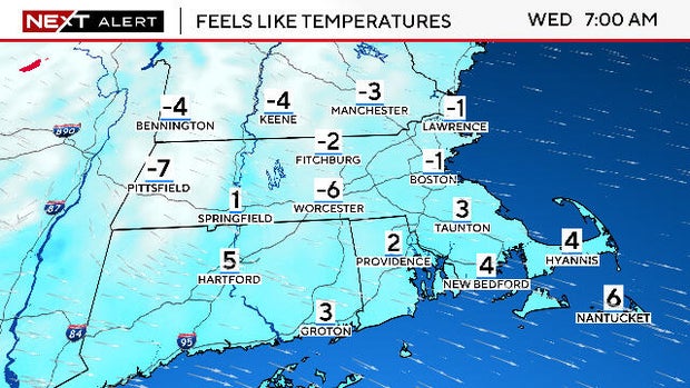
How cold will it be?
Low temperatures will be in the single digits and teens for the next few nights and wind chill values will dip below zero in many areas.
Daily high temperatures will remain below freezing for most of this week across Massachusetts. It will likely take until Friday or Saturday before most of the area rises above 32 degrees again.
Keep in mind that average highs are now close to 40 degrees.

The National Weather Service has issued a somewhat rare Cold Weather Advisory in areas where they expect windchills to drop as low as -15 degrees Tuesday morning.
This includes northern Worcester County as well as northwest Middlesex County as well.
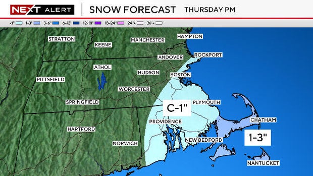
Is there snow Thursday?
There is a light at the end of the tunnel. It now appears as though Massachusetts is going to get a break from the active, stormy pattern.
The storm we have been watching for later this week will likely either graze our area or miss entirely.
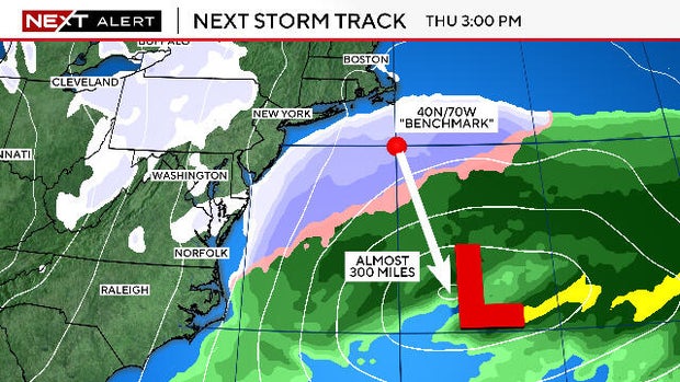
Typically, in order for a storm to bring significant impacts to southern New England, we look for the center of the storm to pass near or inside of "the benchmark." This is a rather arbitrary area in the Atlantic Ocean at 40N/70W, about 100 miles south of Nantucket.
This week's storm is currently forecast to pass about 300 miles south of that area.
A path this far south would spare most of the Mid-Atlantic states as well. However there will be a pretty mean swath of snow from the Plains through North Carolina over the next few days.
The best chance of seeing some accumulating snow in our neck of the woods would be along the South Coast of Massachusetts and on the Cape and Islands late on Thursday.
Weekend weather forecast
Finally, another bit of good news. It looks like we will have our first dry and quiet weekend this month!
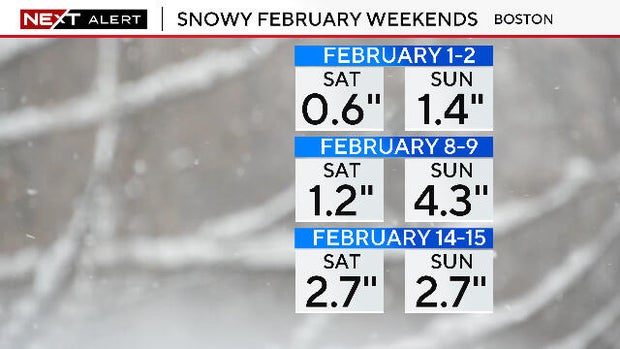
There is currently NO SNOW in the forecast for next weekend. That would be the first two weekend days in February without measurable snowfall in Boston.